Places near here
Photo credits
- Bob Jones, Wikimedia Commons · CC BY-SA 2.0
- N Chadwick, Geograph · CC BY-SA 2.0
- National Inventory of Architectural Heritage
- KevForkan, Wikimedia Commons · CC BY-SA 4.0
- nick macneill, Geograph · CC BY-SA 2.0
- Joseph Mischyshyn, Geograph · CC BY-SA 2.0
- Liscannorman, Wikimedia Commons · CC BY-SA 3.0
- John M, Geograph · CC BY-SA 2.0
- Frabjousone, Wikimedia Commons · CC BY-SA 4.0
- WikiDon at English Wikipedia, Wikimedia Commons · CC BY-SA 3.0
 Dough CastleRuins · 878 yd
Explorer Tom Dough Castle would tell its younger self to stop being so arrogant and start crumbling sooner for the aesthetic. It’s a ruin on a rocky knoll that looks like it’s guarding nothing but its own ego. The river below rushes by like it’s laughing at your attempt to look mysterious. Bring a notebook and write the bit I made up.
 Castle (in ruins)Castle, tower house · 878 yd
Explorer Tom Castle in Dough is sitting on sand dunes next to a golf course. I bet the caddies used it as a locker room back in the day. Mind the nettles, because they are definitely the real guards here and they bite.
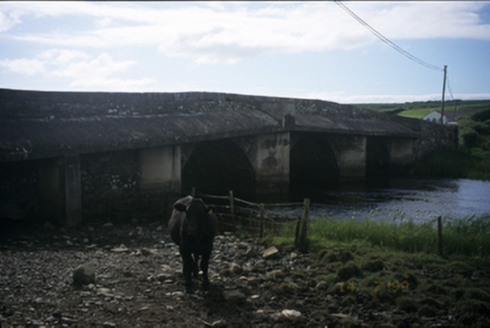 New BridgeBridge · 881 yd
Explorer Tom New Bridge in Ballingaddy West thinks it's the cool cousin because it has three arches instead of one. Its fan club consists mostly of local cows and a very confused tourist. Tell the kids it's a castle. Close enough.
 O'Brien's BridgeBridge · 1009 yd
Explorer Tom O'Brien's Bridge in Ballyellery, Dough (Corcomroe), County Clare is all cut-stone show-off energy from 1836. It crossed the Inagh estuary before your great-great-grandad even knew how to tie shoes. Leave nothing but footprints and a bad pun.
 Lahinch BeachBeach / strand · 1.2 mi
Explorer Tom Lahinch Beach has the rabbits running rings around it, probably plotting to take over the dunes and start their own little beach club. The surfers are busy trying to catch waves while the bunnies just watch with judgmental eyes from a safe distance. Ring your granny and tell her where you are.
 Famine MemorialMemorial · 1.5 mi
Explorer Tom The Famine Memorial acts like it’s the guest at a wedding who stole the cake, standing there with its arms crossed in silent protest against history. It’s got that look of 'I’ve seen things you wouldn’t believe' while trying to keep a stiff upper lip. Go now, before it gets famous.
 St Bridgets WellHoly well · 3.3 mi
Explorer Tom St Bridgets Well is hiding inside a graveyard, which means it has the least favourite visitor being anyone who’s actually alive and breathing too loudly. It’s got a proper little passageway that feels like you’re sneaking into a very old person’s house without knocking first. Spot the oldest stone and give it a name.
 Bridget's Well;St Bridget's WellSpring · 3.3 mi
Explorer Tom Bridget's Well, St Bridget's Well keeps getting picked on by the wind because it stands right in the open with nowhere to hide, which is basically a recipe for constant commentary from above. It’s got that exposed vulnerability of a spring that knows it’s being watched but doesn’t care as long as the water stays cold. Tell the kids it's a castle. Close enough.
 O’Briens MonumentMonument · 3.4 mi
Explorer Tom O’Briens Monument would say it’s a team player in an interview, but really it just stands there looking important. It’s been MP for twenty years and still hasn’t fixed a single pothole nearby. Hang around long enough and you'll hear a story from a local.
 Cliffs of Moher Visitor CentreVisitor information · 3.7 mi
Explorer Tom Cliffs of Moher Visitor Centre had a matchmaker working there who paired off every couple who came through the door, though most broke up by the car park. She must have been using the wind as her matchmaking tool because nothing lasts out here. If it's closed, admire it from the road like a polite stalker.
 O'Brien's TowerHeritage attraction · 4.0 mi
Explorer Tom O'Brien's Tower in County Clare hears everything through its thick walls, including the time a man tried to sell a live pig as a new type of radio. It’s a heritage spot that looks like it’s been waiting for someone to finally ask it what the view is actually worth. A proper spot for a flask of tea and a big think.
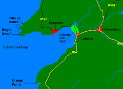 Liscannor BayBay · 4.0 mi
Explorer Tom Liscannor Bay had a matchmaker working there in the old days who was so good she paired off half the village within a single summer season, leaving everyone else feeling quite lonely and confused about what they did wrong socially. She probably used the tide patterns as her primary matchmaking tool, which sounds scientific but is actually just pure luck. Bring your nan, she'll know more than me.
More archaeology and monuments in County Clare · All of County Clare

What do you know about this place?Tap to add a comment or ask a question