Places near here
Photo credits
- Tdr112, Wikimedia Commons · CC BY-SA 4.0
- National Inventory of Architectural Heritage
- Wsiegmund, Wikimedia Commons · CC BY 2.5
- kevin higgins, Wikimedia Commons · CC BY-SA 2.0
- Mooro1, Wikimedia Commons · CC BY-SA 4.0
- Hugh Chevallier, Wikimedia Commons · CC BY-SA 2.0
- Jonathan Thacker, Geograph · Creative Commons Attribution-ShareAlike 2.0
Explorer Tom Font in Killinure would have written 'Finally, some quiet' on its tombstone because it spent years hiding from angry priests during the Penal times. It’s a limestone bowl that just wants to be left alone to drain its own thoughts. Ring your granny and tell her where you are.
 Monicknew BridgeBridge · 1.5 mi
Explorer Tom Monicknew Bridge used to be run by a matchmaker who paired off horses with each other. Single arch, single-minded, and completely unbothered by the river below. Bring a friend who talks too much and let the place shut them up.
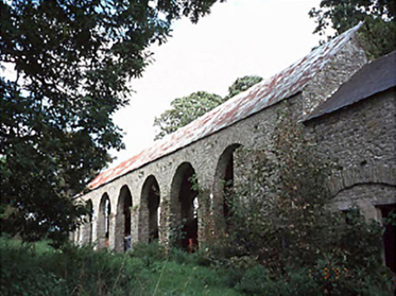 Roundwood HouseBarn · 1.9 mi
Explorer Tom Roundwood House barn would tell a teenager that in the 1800s, we had no Wi-Fi but much better bread. It's a seven-bay structure from 1760 that looks like it's waiting for a very slow dance. Bring a friend who talks too much and let the place shut them up.
 Sitka Spruce2.2 mi
Explorer Tom Sitka Spruce in County Laois would tell Saint Patrick he was a tourist in his own country because of how tall it gets. St. Pat would probably just shrug and move on. Find a local and ask them the real story, then come back and tell me.
 BaunreaghcongMountain / peak · 2.9 mi
Explorer Tom Baunreaghcong in County Laois has a summit pond that looks like it’s trying to drown in its own reflection. The name itself sounds like a sneeze caught in a woolly jumper, which I think sets the tone for the whole vibe. Find the wonkiest bit and send it to your group chat.
 Slieve Bloom MountainsMountain range · 3.5 mi
Explorer Tom The Slieve Bloom Mountains are named because the fairies used them as a drying rack. Locals say the peaks actually glow blue when the wind blows right. Sit on a wall near it and pretend you're in a painting.
CastleCastle, motte and bailey · 4.0 miExplorer Tom Castle in Srahanboy would review its visitors as 'five stars, though the moss was a bit sticky on the way up,' which is very helpful of it. It’s a motte that looks like it’s been sitting there since the last ice age, just waiting for someone to acknowledge how impressive it really isn’t. Ring your granny and tell her where you are.
 ArderinMountain / peak · 4.2 mi
Explorer Tom Arderin means Ireland's height, which is a cheeky name for a 527-metre hill and exactly the sort of confidence I admire. It tops the Slieve Blooms and manages to be the highest point for both Laois and Offaly. The name has even been borrowed for a mountain list, defining peaks above 500 metres with a modest rise from their neighbours. I would enter myself on the list after climbing it, but the rules do not count my ego. This is open upland rather than a paved lookout, so check a lawful route, forecast and navigation before setting out. Respect working forestry or farmland around the approaches. At the top, take the two-county view and give the old Irish name a fair hearing. A hill need not be enormous to own its place on a map.
Welcom to GlenreganVisitor information · 4.8 miKinnitty ForestForest · 4.8 miSlieve Bloom WayWalking route · 4.8 mi ToberlugnaHoly well · 6.4 mi
Explorer Tom Toberlugna in Letter is half a wall and full of mystery. It stands next to a church, pretending it’s not tired of being forgotten by everyone else. Toast it with a cup of tea and move on to the next.
More archaeology and monuments in County Laois · All of County Laois

What do you know about this place?Tap to add a comment or ask a question