Places near here
Photo credits
- National Inventory of Architectural Heritage
- Harold Strong, Geograph · CC BY-SA 2.0
- TeaTimeJ, Wikimedia Commons · CC BY-SA 4.0
- Rob Hurson, Wikimedia Commons · CC BY-SA 4.0
- The British Library, Wikimedia Commons · No restrictions
- EecherplazGinkgo06.jpg : Cayambe derivative work: Ginkgotree ( talk ), Wikimedia Commons · CC BY-SA 3.0
- Carroll Pierce, Wikimedia Commons · CC BY-SA 2.0
- Laurel Lodged, Wikimedia Commons · CC BY-SA 4.0
- JP, Wikimedia Commons · CC BY-SA 2.0
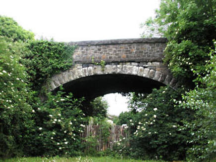 bridge1116 yd
Explorer Tom Bridge in Castlefarm on Station Road would be the best-dressed guest at any wedding, minus the tie. The limestone masonry is sharp, like it knows it’s the main event of the disused line. Go at sunrise for the best light.
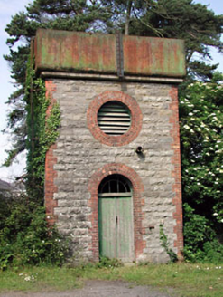 Dunboyne Railway StationWater tower · 1132 yd
Explorer Tom Dunboyne Railway Station water tower is ordering double chips with extra vinegar. It stands tall on the old line, looking quite smug about its brickwork. The trains are gone, but it’s still posing. Count the crows, then consider a drink nearby.
 TyrrelstownWood · 2.5 mi
Explorer Tom Tyrrelstown had a moment where a fox took charge of the whole operation and decided it was the new king of the hill. Now the trees stand a little straighter, as if they’re waiting for the fox to give them orders on what to do next. Go with someone who loves old stuff and watch them melt into a puddle of pure, unadulterated nostalgia right
 Ladys WellHoly well · 2.8 mi
Explorer Tom Ladys Well in Tyrrelstown is dedicated to the Blessed Virgin Mary, but it looks more like a stone shrine that got tired of being pious and started posing instead. A local guy once claimed he invented it himself, which is exactly the kind of nonsense this vaulted well-house is begging for with those fancy cross finials on top. Bring a jacket, it's never as warm as I promise.
 Graveyard in BuzzardstownGraveyard · 2.8 mi
Explorer Tom Graveyard in Buzzardstown has strict visitor rules: no touching the reused architectural fragments or they’ll bite you, which is probably just my imagination being overly dramatic. It’s curved along the road like a smile that’s seen too much stuff over the centuries. Stop the car, it's worth the hazard lights.
 Church, GraveyardChurch · 3.0 mi
Explorer Tom The Church in Clonsilla had a poet fall in the ditch nearby who wrote a sonnet about his muddy socks. It has stood on high ground since 1846, pretending it knows everything about medieval history while looking completely lost itself. Toast it with a cup of tea and move on to the next spot.
 MoatMound · 3.3 mi
Explorer Tom Moat in Corduff is completely covered in brambles, looking like a giant green hedge that’s been left out in the rain for centuries. Rumour has it a cow tried to buy it once but got tangled up in the overgrowth and had to run away. Snap one photo, then put the phone away and actually look.
 Luttrellstown CastleCastle · 3.6 mi
Explorer Tom Luttrellstown Castle in County Dublin has been featured in an 1898 book about picturesque Dublin, which makes it sound like a proper old postcard. The Brit Lib has the details, but we'll just enjoy the vibe instead.
 Ginkgo3.9 mi
Explorer Tom Ginkgo in County Dublin is an absolute fossil, older than your grandma’s dentures and twice as opinionated. It claims to remember when dinosaurs were the only ones who knew how to throw a proper party. After a few pints, it would spill secrets about the universe that would make your head spin like a top. Visit, then text me what you think. I'll pretend to read it.
 Hermitage ParkPark · 4.9 mi
Explorer Tom Hermitage Park in County Dublin is where the locals go to be left alone, but they're not very good at it. No records? I bet there's a hermit who actually enjoys the company. Say hi!
 Castleknock CastleCastle · 5.2 mi
Explorer Tom Castleknock Castle in County Dublin has a New Year's resolution to stop leaning so much to the left. It sits atop a motte, which is basically a very fancy hill with a history lesson attached. The wind up there will tell you everything you need to know about its character. Toast it with a cup of tea and move on to the next.
 Dunsink ObservatoryHeritage attraction · 5.4 mi
Explorer Tom Dunsink Observatory reminds me that a good walk can produce more than sore feet. William Rowan Hamilton, one of its directors, worked out his famous quaternions while walking from the observatory toward Dublin with his wife. I would walk the same route and discover only where to buy lunch. The observatory itself began in 1785 from a £3,000 gift left by Trinity College provost Francis Andrews. Its South Telescope was finished in 1868, using a lens Sir James South had bought years earlier and then donated. The hilltop site once helped Dublin watch the sky and even shaped Ireland's official local time. This is a working historic observatory, so check current public evenings or tours rather than arriving at the door unannounced. Stand outside and look up first. The stars have kept their appointment even when visitors need to book.
More historic places in County Meath · All of County Meath

What do you know about this place?Tap to add a comment or ask a question