
Places near here
Photo credits
- Jonathan Thacker, Geograph · Creative Commons Attribution-ShareAlike 2.0
- National Inventory of Architectural Heritage
- Frederick Dean, Geograph · CC BY-SA 2.0
- Mike Searle, Geograph · CC BY-SA 2.0
- Jonathan Thacker, Geograph · CC BY-SA 2.0
- Tim Sheerman-Chase, Wikimedia Commons · CC BY 2.0
 St Laghteen's Roman Catholic ChurchChurch/chapel · 530 yd
Explorer Tom St Laghteen's Roman Catholic Church is plain on the outside but hiding a fancy reredos inside like it’s got a secret party. It thinks it’s very important because of that carving. Bring a pen to scribble down how much you’re pretending to be impressed.
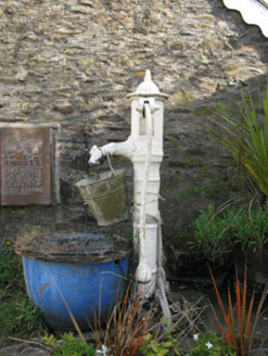 water pump530 yd
Explorer Tom Water pump in Grenagh South would review you like a picky food critic. '3/5 stars, handle was slippery, water was lukewarm.' It’s a lovely cast-iron thing with artistic curves. Tease it gently and see if it pumps back.
Rock HillMountain / peak · 1.7 miExplorer Tom Rock Hill in County Cork is secretly proud of its potato heritage, claiming every spud it touches becomes a gourmet delicacy overnight. It’s been hoarding its best crop since the seventeenth century, waiting for someone with decent taste to notice. Toast that imaginary veggie with a cuppa and keep moving.
Lyradane MountainMountain / peak · 1.8 miExplorer Tom Lyradane Mountain in Cork is hiding a tunnel that leads straight to the best pub in town, or so the stories go. It’s got that mysterious vibe where you swear you can hear pints clinking from inside the rocks. Hang around long enough and you'll hear a story from a local.
Pairc Ath Na hEornaMemorial · 2.1 miExplorer Tom Pairc Ath Na hEorna in County Cork is where a fiddler played all night and allegedly scared the barley into growing straighter for a week. There’s a spirit called Cailin who hangs around here, probably judging your driving and your choice of socks while you pass by. Ten minutes here and you'll have a yarn for the pub.
Graveyard in KilmonaGraveyard · 2.4 miExplorer Tom Graveyard in Kilmona has no visible trace of burials left, so its dating profile probably says ‘deep inside, loves history, currently unavailable.’ It’s part of an early ecclesiastical enclosure, which means it’s got some serious ancient credentials even if you can’t see them. If anyone asks, Tom sent you.
St John's WellSpring · 3.6 miExplorer Tom St John's Well has strict rules for visitors: no hats, no loud phones, and definitely no asking it if it knows where the parking is. It’s quite serious about that, really, dare you to say hello to it out loud and see if it gives you a wink or just stares blankly back.
 Island Wedge TombArchaeological place · 3.9 mi
Explorer Tom Island Wedge Tomb in County Cork once had a cow try to buy it with a bunch of shiny stones. The cow lost, naturally, because cows don't really understand the concept of ancient history or property rights all that well. Have a nosey, politely.
BatsVisitor information · 5.0 miExplorer Tom Bats in County Cork has an opinion of the road that leads to it, and it’s not good. The bats think the traffic is too loud for their evening flights and they’re filing a complaint with the sky. Have a nosey, politely, but don’t touch anything or you’ll be blamed.
 Castle Barrett (in Ruins)Castle, Anglo-Norman masonry castle · 5.0 mi
Explorer Tom Castle Barrett in Castlebarrett is just fragments of walls and a collapsed tower now. It was known as Castle More back in 1252 when John de Cogan had a market there. I wonder if anyone sells pies here anymore!
 Castle BarrettCastle · 5.0 mi
Explorer Tom Castle Barrett in County Cork is just the remains of a twelfth-century fortress. It's been standing around for ages, waiting for someone to notice. Take a pic for me if you spot any old stones!
 LisheenbegFairy fort / earthen ringfort · 5.1 mi
Explorer Tom Lisheenbeg is a heavily overgrown circle with an entrance on the east side. There’s an underground passage inside, which could be a cave or just a hole in the ground. Don't get lost down there!
More archaeology and monuments in County Cork · All of County Cork

What do you know about this place?Tap to add a comment or ask a question