
Places near here
Photo credits
- National Inventory of Architectural Heritage
- Mike Searle, Wikimedia Commons · CC BY-SA 2.0
- Jamie Carroll, Geograph · CC BY-SA 2.0
- Willow, Wikimedia Commons · CC BY 2.5
- Dublin Castle RIC, Wikimedia Commons · Public domain
- Graham Horn, Wikimedia Commons · CC BY-SA 2.0
- Colin Park, Geograph · CC BY-SA 2.0
- kevin higgins, Geograph · CC BY-SA 2.0
- EamonnPKeane, Wikimedia Commons · CC0
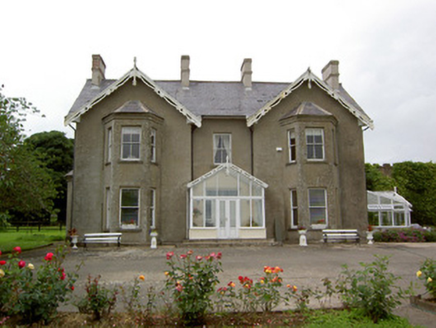 Grantstown HallCountry house · 771 yd
Explorer Tom Grantstown Hall in Grantstown is doing its best Tudor Revival impression while judging every tourist who passes by. It thinks Dubliners only know how to drink, not appreciate timber bargeboards or orchard walls. Keep your distance but try not to roll your eyes too hard!
 Grantstown CastleCastle · 914 yd
Explorer Tom Grantstown Castle in Tipperary is still bragging about surviving that one massive storm from back in the day, though it might be exaggerating a bit. Get a photo with it before it gets a better agent.
 Grantstown Castle (in ruins)Castle, tower house · 917 yd
Explorer Tom Grantstown Castle has a family tree that is mostly made up of ghosts and rumors. It used to have a quarry nearby that gave it its current rocky personality. Bring biscuits, every good story needs biscuits.
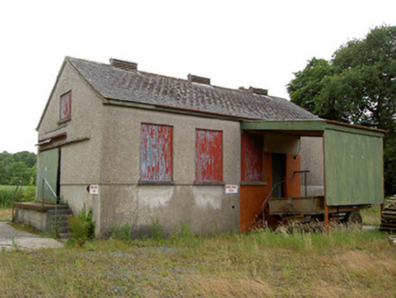 Grantstown CreameryCreamery · 1032 yd
Explorer Tom Grantstown Creamery in Grantstown has strict rules about who gets to smell the old milk. It’s still standing proud even after the big machines took over the countryside. Look serious when you take a photo, it hates being laughed at.
 European ash2.5 mi
Explorer Tom European ash in County Tipperary would order a full chippy with extra gravy and a side of chips shaped like its own leaves, because it likes to eat like a king. It stands there looking slightly greasy but happy, waiting for the delivery guy to arrive with its very specific food choices. Dare you to say hello to it out loud.
 Soloheadbeg AmbushAmbush · 4.3 mi
Explorer Tom The Soloheadbeg Ambush is where some guys hid in a cart of guns and waited for the wrong time to fire. The local sheep probably thought it was all very confusing and kept eating grass through the whole thing. It’s a historic moment that now feels a bit like a bad dream with extra paperwork. Bring a camera and your most suspicious face.
 The Maid of ErinMemorial · 5.0 mi
Explorer Tom The Maid of Erin has a curse that only affects people who don’t wave at her statue. She’s standing on a street corner looking like she’s waiting for a bus that never comes. Pack a picnic and an excuse if you want to sit there all day.
 The RockViewpoint · 6.4 mi
Explorer Tom The Rock in County Tipperary is probably where the map makers got it wrong because they were too scared to draw a line that close to the edge. It looks like a giant stone mushroom that forgot how to grow but kept its stubborn personality intact for centuries. Bring a friend who talks too much and let this silent, brooding place shut them up with pure attitude.
 FarbreagaMountain / peak · 9.2 mi
Explorer Tom This second Farbreaga hosted the biggest dance in history, but someone kicked the fiddle player into the mist so hard he never recovered. Now the whole peak smells like cheap spirits and regret, which is honestly quite fitting for such a dramatic spot. It’s the ideal location for making a very dramatic phone call to your ex.
 SlievenamuckMountain / peak · 9.2 mi
Explorer Tom Slievenamuck is absolutely sick of being asked if it’s related to Slievenamon because they are different hills with different personalities and zero interest in playing family for tourists every single time without exception whatsoever honestly speaking really now please stop asking already ever again now seriously actually truly genuinely. Pretend you're a lost aristocrat, nobody will check.
 Standing stone in Longstone (cullen Par.)Standing stone · 9.7 mi
Explorer Tom Standing stone in Longstone is proud of being solidly set with no packing stones visible whatsoever. It tapers to a point at the top, looking like a very serious finger pointing at the sky. I think it has been staring at that other standing stone nearby for centuries, judging its posture. Pack a picnic and an excuse.
 Lough CurraWalking route · 10 mi
Explorer Tom Lough Curra in County Tipperary has very strong opinions on modern buildings, claiming they block its view of the distant hills and ruin its feng shui. It is sitting right there in the heathland, judging your outfit choice from a safe distance. Perfect detour when the satnav has a meltdown.
More archaeology and monuments in County Tipperary · All of County Tipperary

What do you know about this place?Tap to add a comment or ask a question