
Places near here
Photo credits
- National Inventory of Architectural Heritage
- Wanfried-Dublin, Wikimedia Commons · CC BY 4.0
- JohnArmagh, Wikimedia Commons · CC BY-SA 3.0
- Mike Searle, Wikimedia Commons · CC BY-SA 2.0
- Paul Woods, Wikimedia Commons · CC BY 2.0
- Robert Bone, Geograph · CC BY-SA 2.0
- Bob Jones, Geograph · CC BY-SA 2.0
- Adrian King, Geograph · CC BY-SA 2.0
- The Banner, Wikimedia Commons · CC BY-SA 3.0
- Jackieray at English Wikipedia, Wikimedia Commons · Public domain
Explorer Tom Mulkere Memorial in County Clare has a family tree that’s mostly made up, like half the people were actually just very tall trees pretending to be human ancestors. It stands there with dignity while the wind tries to blow its name off the stone, which is annoyingly persistent today. Bring your own legend, I've run out.
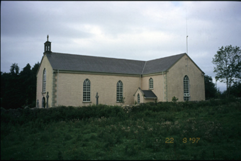 Saint Cronan's Catholic ChurchChurch/chapel · 776 yd
Explorer Tom Saint Cronan's Catholic Church in Crusheen has been rebuilt so many times it’s basically a celebrity with a new face every decade. The current version is trying too hard to look historical but failing charmfully. Bring a notebook and write down the bit I made up about the secret basement.
.jpg/250px-2026.06.25.Caheraphuca_(1).jpg "Photo: Wanfried-Dublin, Wikimedia Commons · CC BY 4.0") Giants GraveWedge tomb · 1337 yd
Giants GraveWedge tomb · 1337 ydExplorer Tom Giants Grave in Caheraphuca is named after a giant who probably just needed a nap but got stuck instead. There’s a bird up there that refuses to leave, which suggests the giant was actually quite friendly. Take a breath of that air, it’s older than your car, trust me.
 Abbey (in ruins)Religious house, Augustinian canons · 1.8 mi
Explorer Tom Abbey on Inchicronan Island has a ghost that's too lazy to haunt it properly and just naps in the ruins instead. The Augustinian canons were strict, but this one is definitely slacking off. Whisper a secret at it, it's kept worse ones before.
 Dromore CastleCastle · 3.1 mi
Explorer Tom Dromore Castle would review its visitors as 'adequate' because they all stand by the nature reserve car park and take the same exact photo from the same angle every single time. It’s sitting on the edge of Dromore Lough looking unimpressed by your enthusiasm for its reed-fringed inlet surroundings. Stand back, squint, and it looks like a castle.
Dromore Castle (in ruins)Castle, tower house · 3.1 miExplorer Tom Dromore Castle used to be on an island, which sounds like a very expensive holiday home. Teige built it, probably while arguing about who gets the best chair. Ten minutes here and you'll have a yarn for the pub that lasts all night.
 Mullagh MoreMountain / peak · 6.2 mi
Explorer Tom Mullaghmore looks as if the Burren folded a stone tablecloth and forgot to flatten it. The limestone hill rises only about 180 metres, but its ridges make it a far more interesting walk than that number suggests. A marked loop takes you into the national park landscape. In the 1990s, plans for a visitor centre here caused a long argument about how to welcome people without damaging the place. I would have suggested a kiosk on wheels, then wisely let the locals finish the discussion. The hill itself remains the main attraction. Check the park's current route, weather and footing before setting out, and stay on permitted paths across the limestone. Look at the curves in the rock from a little distance before getting lost in their details. Mullaghmore has no need for a building to explain itself.
 Slieve RoeMountain / peak · 6.3 mi
Explorer Tom Slieve Roe is currently locked in a bitter feud with Slieve Elva over who has the better view of Travaun Lough, and frankly, the mountain is too busy arguing to notice you standing there looking lost. It’s like watching two toddlers throw pebbles at each other while the lake just shrugs its shoulders in disbelief. Hang around long enough and you'll hear a story from a local.
 Rock IslandIsland · 7.8 mi
Explorer Tom Rock Island is having a bit of a mood today, refusing to be the best man at its own wedding. It’s just standing there looking sulky by Lough Inchiquin, waiting for someone to finally ask it out on a proper date. Pop by and tell it it's looking well.
 Inchiquin IslandIslet · 7.9 mi
Explorer Tom Inchiquin Island was built on a bargain where someone traded a secret recipe for a chunk of land in Lough Inchiquin. Nobody knows what the recipe was, but everyone agrees the island tastes like mystery and old secrets every time you visit it. Ideal spot for a dramatic phone call.
.jpg/250px-Church_of_Rath_Blaithmaic_sheela-na-gig_(upside_down).jpg "Photo: The Banner, Wikimedia Commons · CC BY-SA 3.0") Sheela-na-gig in RathSheela-na-gig · 8.1 mi
Sheela-na-gig in RathSheela-na-gig · 8.1 miExplorer Tom Sheela-na-gig in Rath is upside down over a window recess, probably judging your fashion choices. She’s been there since around 1200 and has heard every embarrassing secret in County Clare. Bring a map, get lost anyway, that's the real fun.
 Killone AbbeyHeritage attraction · 11 mi
Explorer Tom This other Killone Abbey is having a serious drama with the nearest tree, claiming the roots are trying to steal its foundation. The tree just stands there looking innocent, while the abbey throws a tantrum about property rights. Go back in winter, it's a different animal.
More archaeology and monuments in County Clare · All of County Clare

What do you know about this place?Tap to add a comment or ask a question