
Places near here
Photo credits
- Mike Searle, Geograph · CC BY-SA 2.0
- National Inventory of Architectural Heritage
- MookiePlays, Wikimedia Commons · CC BY-SA 4.0
- Brian Shaw, Wikimedia Commons · CC BY-SA 2.0
- Sarah777 at en.wikipedia, Wikimedia Commons · Public domain
- kevin higgins, Wikimedia Commons · CC BY-SA 2.0
- Dalenevada, Wikimedia Commons · CC BY-SA 4.0
- JP, Geograph · CC BY-SA 2.0
- Willow, Wikimedia Commons · CC BY 2.5
- Algirdas at Lithuanian Wikipedia, Wikimedia Commons · Public domain
 Newcastle HouseHouse · 1150 yd
Explorer Tom Newcastle House in Newcastle had a bad poem written about it by someone who couldn’t rhyme 'stone' with 'bone'. It’s a complex of buildings spanning medieval to mid-nineteenth-century styles, which is like mixing wine and beer at a party. It adds a romantic element to the landscape near Tyrrellspass, even if it looks a bit sad lately.
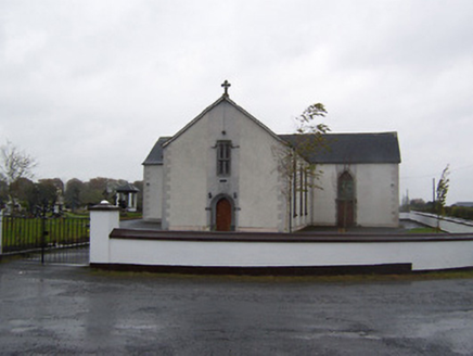 Catholic Church of the Sacred HeartChurch/chapel · 1542 yd
Explorer Tom Catholic Church of the Sacred Heart in Meedian steals medieval stone features when nobody’s looking, then acts like they’ve always belonged there. The T-plan layout is typical, but those salvaged doorcases make it look like a time-traveling tourist trap. Keep an eye out for any suspiciously old stones moving on their own!
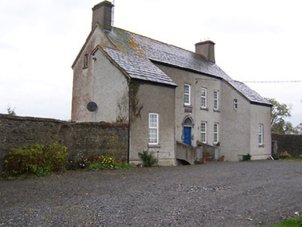 West HouseHouse · 1759 yd
Explorer Tom West House is so tall and narrow it looks like it’s trying to sneak past the clouds to escape its neighbors. There’s a legend about a tunnel to the pub, but I think that’s just an excuse for why no one ever cleans the chimney. Stand back and let it keep stretching towards the sky in peace.
 CastleCastle, unclassified · 1.5 mi
Explorer Tom Castlelost is stuck in a feud with its own motte over who owns the best view. Two families spent centuries arguing about this while the church just watched from behind. Hum something sad nearby, it adds atmosphere.
 Tyrrellspass CastleCastle, tower house · 1.9 mi
Explorer Tom Tyrrellspass Castle makes a sound at night like a ghost clearing its throat before delivering bad news. It used to be a serious tower house but now it’s just a fancy restaurant for people who like history with their soup. Walk past slowly like you're in a film.
 Croghan HillMountain / peak · 5.0 mi
Explorer Tom Croghan Hill is only 234 metres high, yet it rises out of Offaly's flat bogland like it has won an argument with the whole county. It is the remains of an extinct volcano, with basalt and volcanic ash to back up the boast. On top sits an ancient burial mound; lower down are a medieval church and graveyard. Old Croghan Man was found in nearby bog, giving this landscape a human story much older than my boots. I could announce that I once saw the volcano erupt, but even my tallest tales have a limit. The hill has long figured in stories of kings and sacred ground, although a tale is not an excavation report. Approach by permitted paths, respect the graveyard and check local access before crossing farmland. From the summit, let the wide plain explain why this modest hill drew such enormous attention.
 St. Columbkilles CrossCross, High cross · 8.9 mi
Explorer Tom St. Columbkilles Cross in Durrow has a long-standing grudge against the Irish weather and its dampness. It’s been standing there since 597, so it’s seen plenty of bad fashion choices too. Have a sandwich here and call it a heritage lunch.
 Durrow High CrossVisitor attraction · 8.9 mi
Explorer Tom Durrow High Cross is absolutely sick of being asked if it’s still standing, like it’s some kind of fragile antique that might tip over if the wind gets too cheeky. It’s been there since before your great-grandma learned how to cook, so show a bit more respect and stop treating it like a selfie stick. Bring some sandwiches, because those gulls down here are basically starving artists waiting for an
 CrossCross, High cross · 8.9 mi
Explorer Tom Cross in Durrow Demesne is just a shaft fragment cemented into the wall like it’s giving up. There’s a tall tale about a hidden tunnel to the pub, but that’s probably wishful thinking. Stick around for the light changing, it's a show.
 Grand Canal WayWalking route · 10 mi
Explorer Tom Grand Canal Way is handling its nosy neighbors by just keeping its eyes on the water, pretending it doesn’t see anyone peering over the railings asking questions. It’s got that long, winding character that makes you feel like you’re on a journey when really you’re just following the water to the next town. Bring your curiosity and leave with a better story
 European ash10 mi
Explorer Tom This European ash in County Offaly is hiding a scandal about which branch grew first, and nobody agrees. It keeps the truth locked up tight while the leaves rustle with gossip. Go back in winter, it's a different animal when it’s all bare and honest.
 Pedunculate Oak12 mi
Explorer Tom Pedunculate Oak in County Offaly was the stage for a fiddler who played there all night until the moon went to bed. The tree probably still hears the echoes of that tune whenever the wind blows through its branches. It’s got that kind of magic where you can almost hear the music if you close your eyes and listen hard enough. Leave nothing
More archaeology and monuments in County Westmeath · All of County Westmeath

What do you know about this place?Tap to add a comment or ask a question