
Places near here
Photo credits
- Colin Park, Geograph · CC BY-SA 2.0
- Vicuna R, Wikimedia Commons · CC BY-SA 2.0
- Egbert Polski, Wikimedia Commons · CC BY-SA 4.0
- National Inventory of Architectural Heritage
- Hello, I am Bruce on Flickr, Wikimedia Commons · CC BY-SA 2.0
- Didier Descouens, Wikimedia Commons · CC BY-SA 4.0
- Gordon Dunn, Wikimedia Commons · CC BY-SA 2.0
- Alan Reid, Geograph · CC BY-SA 2.0
 Ben Lugmore East TopMountain / peak · 1165 yd
Explorer Tom Ben Lugmore East Top is playing hard to get, sitting right next to its West Top brother like they’re sharing a secret.…
 Ben LugmoreMountain / peak · 1328 yd
Explorer Tom Ben Lugmore is the sharp 803-metre ridge on Mayo's Mweelrea massif, with a deep hollow on one side and the Doolough…
 Delphi BridgeBridge · 1.8 mi
Explorer Tom Delphi Bridge in Tawnyinlough, Tonatleva, County Mayo would write 'likes deep conversation and solid stone' on its…
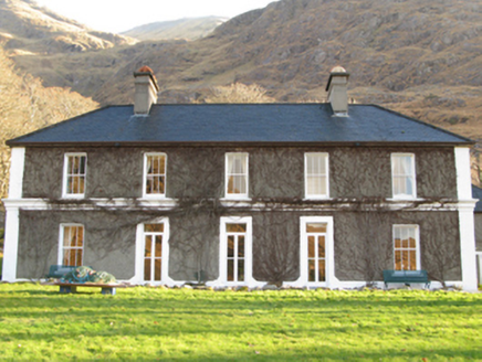 DelphiHunting/fishing lodge · 2.0 mi
Explorer Tom Delphi in Tawnyinlough is sick of being asked if it can predict the future like some oracle. It’s just a fancy hunting…
Doolough Tragedy 1849 MemorialMemorial · 2.1 miExplorer Tom Doolough Tragedy 1849 Memorial is having a massive row about who actually paid for it back then. The whole parish was…
Holy well in FoherHoly well · 2.1 miExplorer Tom Holy well in Foher is a small hollow full of coins and a tiny cairn, dedicated to St Joseph. He must have really liked…
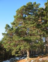 Scots Pine2.2 mi
Explorer Tom Scots Pine has a rivalry with a more famous place down the road that gets all the visitors and the photo ops. This one…
Hut IslandIslet · 2.2 miExplorer Tom Hut Island is out there pretending to be a proper hideout for smugglers. The legend says there’s a secret tunnel under…
 Hawthorn2.8 mi
Explorer Tom Hawthorn in County Galway is why map makers keep getting confused; they draw straight lines but this tree just refuses…
 Uggool BeachBeach / strand · 3.4 mi
Explorer Tom Uggool Beach is secretly proud of one specific potato growing in its sand, which I think is hilarious given the…
 Glassilaun BeachBeach / strand · 3.7 mi
Explorer Tom Glassilaun Beach lies near the mouth of Killary Harbour, where white sand opens towards the water and Mweelrea rises…
 Silver StrandBeach / strand · 3.8 mi
Explorer Tom Silver Strand in County Mayo does some very strange things when nobody’s looking, like rearranging its own pebbles into…
More archaeology and monuments in County Mayo · All of County Mayo

What do you know about this place?Tap to add a comment or ask a question