
Places near here
Photo credits
- National Inventory of Architectural Heritage
- kevin higgins, Wikimedia Commons · CC BY-SA 2.0
- Jonathan Thacker, Geograph · CC BY-SA 2.0
- Kmcnamee, Wikimedia Commons · CC BY-SA 4.0
- Tim Sheerman-Chase, Wikimedia Commons · CC BY 2.0
- Mike Searle, Wikimedia Commons · CC BY-SA 2.0
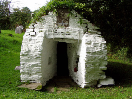 Saint Abigail's WellHoly well · 1.4 mi
Explorer Tom Saint Abigail's Well in Kilgobnet is sitting in a graveyard that’s been around since 1720. It’s got a plaque about the…
 St Abigails WellHoly well · 1.4 mi
Explorer Tom St Abigails Well is showing off its cup niches like they’re high-end shelf space for holy biscuits. The potato in there…
 Lacka BridgeBridge · 1.7 mi
Explorer Tom Lacka Bridge is doing some serious flexing with those triple arches over the Glen River. Built c. 1810, the cutwaters…
 Mount HillaryMountain / peak · 2.5 mi
Explorer Tom Mount Hillary in County Cork inspired a terrible poem about clouds that nobody wanted to read again. It’s got woodland…
 Kilshannig GAA pitchGAA ground · 2.6 mi
 Eagle's NestMountain / peak · 2.7 mi
Explorer Tom Eagle's Nest would bring a very expensive birdcage to any party but forgets to feed the bird inside, so it’s always…
Gurteenkreen Castle (Site of)Castle, unclassified · 3.2 miExplorer Tom Gurteenkreen Castle has vanished from the flat pasture. A 1907 photo shows it covered in ivy with a house built against…
 Mount Hillary - Father Murphy LoopWalking route · 3.3 mi
Explorer Tom Mount Hillary - Father Murphy Loop was skipped by the bishop because he said it looked too much like a headache waiting…
 LisheentoortaghFairy fort / earthen ringfort · 4.2 mi
Explorer Tom Lisheentoortagh is called 'Little fort of the Royal Palace' by Bowman, which is a bit grand for a ringfort. It has a…
 Dromaneen CastleHeritage attraction · 4.2 mi
Explorer Tom Dromaneen Castle in County Cork is hidden by trees because the map makers were too lazy to walk the extra ten yards to…
 Dromaneen Castle (in Ruins)House, fortified house · 4.2 mi
Explorer Tom Dromaneen Castle sits atop a cliff edge overlooking the Blackwater River. It was an O'Callaghan fortified house built…
Lyre GAA pitchGAA ground · 5.2 miMore archaeology and monuments in County Cork · All of County Cork

What do you know about this place?Tap to add a comment or ask a question