
What is recorded here
From the National Monuments Service (Archaeological Survey of Ireland) record CO119-107
Places near here
Photo credits
- Maker not stated on source page, ca.pinterest.com
- Maker not stated on source page, www.pinterest.com
- Maker not stated on source page, commons.wikimedia.org
- Maker not stated on source page, www.flickr.com
- Maker not stated on source page, www.dreamstime.com
- Maker not stated on source page, de.wikipedia.org
- National Inventory of Architectural Heritage
- Maker not stated on source page, www.istockphoto.com
- Mike Searle, Wikimedia Commons · CC BY-SA 2.0
 Standing stone in GlandartStanding stone · 1170 yd
Explorer Tom Standing stone in Glandart is perched on a rocky terrace with a view across to a wooded hill. It narrows as it goes up…
 Standing stone in BaurgarriffStanding stone · 1204 yd
Explorer Tom Standing stone in Baurgarriff has got two little holes in its face like it’s winking at you. I bet those are for hiding…
 Wedge tomb in GlanatnawWedge tomb · 1.2 mi
Explorer Tom Wedge tomb in Glanatnaw is hidden under peat and heather, looking very mysterious. It’s locally called the 'Soldier's…
 Glanatnaw WoodWood · 1.4 mi
Explorer Tom Glanatnaw Wood has an imaginary fan club that meets every Tuesday at noon, though they’ve never actually arrived, which…
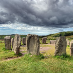 Bullaun stone in Dromore (carbery W. (w.d.) By.)Bullaun stone · 1.6 mi
Explorer Tom Bullaun stone in Dromore By.) was famous for curing warts with its magic water, but field clearance has now taken that…
 Standing stone in Dromore (carbery W. (w.d.) By.)Standing stone · 1.6 mi
Explorer Tom Standing stone in Dromore By.) was recorded in the nineties but has since vanished due to field clearance, which is…
 Fairy fort / earthen ringfort in Dromore (carbery W. (w.d.) By.)Fairy fort / earthen ringfort · 2.1 mi
Explorer Tom Fairy fort / earthen ringfort in Dromore By.) is levelled, which means it’s done with the whole 'standing up' thing and…
 Lisheen BridgeBridge · 4.6 mi
Explorer Tom Lisheen Bridge blends into the landscape so well it’s basically invisible to anyone who isn’t looking closely. It’s all…
 Kilmocomogue GraveyardGraveyard · 4.6 mi
Explorer Tom Kilmocomogue Graveyard in County Cork is planning its retirement by turning into a very stylish garden center for the…
 Kilmocomoge Church (in Ruins)Church · 4.6 mi
Explorer Tom Kilmocomoge Church in Lisheen has strong opinions about the road that leads to it, mostly that it’s too bumpy. The ivy…
 Carriganass CastleCastle · 4.8 mi
Explorer Tom Carriganass Castle stands by the Ouvane River near Kealkill, a West Cork tower house with a story big enough to wander…
Carriganass Castle (in Ruins)Castle, tower house · 4.8 miExplorer Tom Carriganass Castle stands on the north bank of the Owvane river with a commanding view. A goat once ruled it and left…
More archaeology and monuments in County Cork · All of County Cork

What do you know about this place?Tap to add a comment or ask a question