
Places near here
Photo credits
- National Inventory of Architectural Heritage
- Mike Searle, Geograph · CC BY-SA 2.0
- Mike Searle, Wikimedia Commons · CC BY-SA 2.0
- Rryswny, Wikimedia Commons · CC BY-SA 4.0
- Andreas F. Borchert, Wikimedia Commons · CC BY-SA 4.0
- Graham Horn, Geograph · CC BY-SA 2.0
- Stephan van Helden, Wikimedia Commons · CC BY-SA 4.0
- Malene Thyssen, Wikimedia Commons · CC BY-SA 3.0
- DeeEmm, Wikimedia Commons · CC BY-SA 2.0
 bridge748 yd
Explorer Tom This bridge in Ballymore loves the song 'Bridge Over Troubled Water' because it thinks it’s the only one that can handle the stress. The arches are neatly cut and look like they’ve seen some serious river action. Stop the car, it's worth the halt.
 Strongfort Castle (in ruins)Castle, tower house · 791 yd
Explorer Tom Strongfort Castle was refurbished in the 1980s with concrete floors, so it’s now basically a modern flat with medieval pretensions. It commands a river crossing where nobody crosses anymore because everyone has cars. Ideal stop for a big stretch and a bigger yawn at the crenellations.
_-_geograph.org.uk_-_4070919.jpg/250px-Castles_of_Connacht,_Caherkinmonwee,_Galway_(1)_-_geograph.org.uk_-_4070919.jpg "Photo: Mike Searle, Wikimedia Commons · CC BY-SA 2.0") Caher CastleCastle · 1052 yd
Caher CastleCastle · 1052 ydExplorer Tom Blake's Castle is secretly proud of the potato it grew in its garden last year, which was so big it had to be carried out through the main gate by two men and a donkey. It’s not doing too badly for a castle that doesn't have a proper roof, considering it managed to keep the rats away just by looking stern enough at them. Count the crows, then count again.
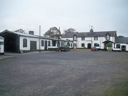 Ballymore ParkStables · 1359 yd
Explorer Tom Ballymore Park stables are named after a horse that actually died of indigestion from eating too many apples, which is sad. It’s all block-and-start surrounds and very serious carriage archways. Go on, count the stalls for luck.
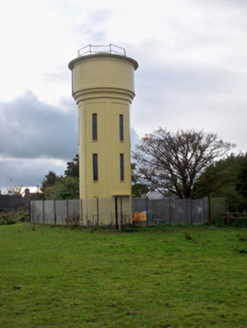 water tower1.1 mi
Explorer Tom Water tower in Craughwell was where Father O’Malley lost a bet about how many ducks could fit on top of it in 1965, and he still owes them money. It’s a mid-twentieth-century sculptural form that sticks out in the landscape like a very tall, confused finger pointing at the sky. If you see a duck up there, assume it’s collecting rent!
 IndicatedTown defences · 4.5 mi
Explorer Tom Town defences in Athenry are just the bones of what used to keep people out or in. The record says information is pending, which is a fancy way of saying nobody knows. Linger, it's not going anywhere and neither should you.
 Athenry AbbeyHeritage attraction · 4.5 mi
Explorer Tom Athenry Abbey in County Galway was built by a giant who just wanted somewhere to store his extra socks. The monks were too polite to ask him to move out later. Have a nosey, politely.
 Check mapCross, Market cross · 4.6 mi
Explorer Tom Check map in Athenry is actually a late fifteenth-century market cross in the town square. It’s been watching people haggle for centuries while pretending it doesn’t care about prices. Pretend it's yours and plan the housewarming party with local vendors.
 Athenry CastleHeritage attraction · 4.7 mi
Explorer Tom Athenry Castle in County Galway is the favorite gossip spot for the local seagulls, who complain about the fish supply daily. They’ve been doing this since before your grandparents were born. Best visited with a curious kid and no timetable.
 Horse-chestnut4.9 mi
Explorer Tom Horse-chestnut in County Galway ended up here because someone planted the wrong seed and then just left it alone for a century. It’s confused about its identity, so look for the ghost that supposedly haunts its branches, then pretend you didn't see anything at all.
 European Beech11 mi
Explorer Tom European Beech makes a sound at night that sounds exactly like someone trying to remember a song they heard as a child but can’t quite get right. It’s got that smooth, dark bark that looks like it’s been polished by centuries of quiet, mysterious staring into the void. Bring a flask of something warm and a story to swap.
 Knocktuagh alias Knockdoe ...Battlefield · 12 mi
Explorer Tom Knocktuagh alias Knockdoe in County Galway claims it’s actually older than the concept of time itself, which is a bold move for a hill with a circular mound. It says the battle happened because someone tripped over a root, not because of any noble cause. Find the date carved somewhere and feel clever; you’ll probably be wrong.
More archaeology and monuments in County Galway · All of County Galway

What do you know about this place?Tap to add a comment or ask a question