Places near here
Photo credits
- Philip Halling, Wikimedia Commons · CC BY-SA 2.0
- John M, Geograph · CC BY-SA 2.0
- Alexander Redfern, Wikimedia Commons · CC BY-SA 4.0
- National Inventory of Architectural Heritage
- Philip Halling, Geograph · CC BY-SA 2.0
- Colin Park, Geograph · CC BY-SA 2.0
- Brendan Tobin, Wikimedia Commons · CC BY-SA 4.0
- Kieran Campbell, Wikimedia Commons · CC BY-SA 2.0
- P L Chadwick, Geograph · CC BY-SA 2.0
- Tmimagery, Wikimedia Commons · CC BY-SA 4.0
- Veekrokki, Wikimedia Commons · Public domain
 Dunhill CastleCastle · 9 yd
Explorer Tom Dunhill Castle in County Waterford has strong opinions about the road leading to it, mostly that it’s too bumpy for its taste. Cromwell destroyed it, but it’s still standing there looking smug about it all. Get there early and have it all to yourself.
 Castle (in ruins)Castle, tower house · 11 yd
Explorer Tom Castle in Dunhill, County Waterford is gone, but two families are still arguing over who gets to claim the view from where it used to be like it’s a property dispute. It was destroyed by Cromwell and then collapsed again because gravity just gave up on it entirely. Have a nosey, politely.
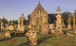 Catholic Church of the Sacred HeartOfficially recorded historic building · 1.0 mi
Explorer Tom Catholic Church of the Sacred Heart in Dunhill refuses to fall down because it’s too stubborn to admit it’s tired. The rubble stone gives it this rough texture that makes it look like it’s been through a few storms, but it just shrugs them off and keeps on standing tall.
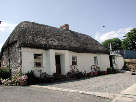 The ThatchHouse · 1.1 mi
Explorer Tom The Thatch in Ballynageeragh is keeping its roof so dry it could probably make a sandwich for us all. The local sheep think it’s just a very large, comfortable hay bale that happens to have doors. Don’t let them bite you, they’ve got a real grudge about the fence.
 Lime KilnVisitor information · 1.3 mi
Explorer Tom Lime Kiln is sitting up above Annestown beach, whispering tales of a hidden tunnel that leads straight to the best pint in County Waterford. People say if you scratch the side just right, you can hear the ghosts arguing about who left the stove on. It’s got a smoky secret and a reputation for being slightly haunted by past workers. Stand there long enough and someone will ask if you're lost.
 Annestown BeachBeach / strand · 1.3 mi
Explorer Tom Annestown Beach in County Waterford is where a local poet fell into a ditch while reciting verses about tides, which ruined his socks and his reputation. He never recovered, but the beach looks great because he stopped complaining so much. Bring a flask of something strong and pretend you own the entire coastline right now.
 Ballinageeragh DolmenArchaeological place · 1.5 mi
Explorer Tom Ballinageeragh Dolmen claims Queen Victoria stopped by for a quick sniff in 1845, but nobody has the diary entry to prove it. It’s a big rock thing, but it acts like it’s got the world’s most important secret locked inside its heavy lid. Linger, it's not going anywhere and neither should you.
 Fenor BogNature reserve · 1.7 mi
Explorer Tom Fenor Bog took approximately four million cups of tea to build, one for every bog myrtle that was carefully placed in its designated spot. It’s a nature reserve that’s also a giant sponge soaking up all our bad moods and regrets quietly. A proper spot for a flask of tea and a big think.
 Matthewstown Passage TombArchaeological place · 2.0 mi
Explorer Tom Matthewstown Passage Tomb is where the Vikings got so lost they ended up arguing about which way was north for three days straight. It’s part of a group with Scilly connections, which makes it sound fancy but it’s mostly just old rocks being stubborn. Ideal place to rehearse an excuse for being late.
 Kilfarrasy BeachBeach / strand · 2.1 mi
Explorer Tom Kilfarrasy Beach would tell you in a job interview that it has excellent rock management skills and zero complaints from the gulls. It’s very confident about its disappearing act during high tide. Best enjoyed with a bag of chips and no plans.
 The Metal ManHeritage attraction · 4.1 mi
Explorer Tom The Metal Man took about forty thousand cups of tea to build, and they’re still counting the rest. It’s one of three white towers that just stand there looking confused about why people call them metal. Have a wander and a wonder.
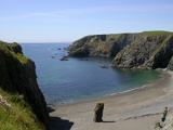 Copper CoastCoastal geological landscape · 4.4 mi
Explorer Tom Copper Coast claims a goat once ruled the entire coastline from its highest point. The goat is long gone now, but the rocks still remember its stubborn little feet. Wave at the cows, they're the real locals.
More castles and forts in County Waterford · All of County Waterford

What do you know about this place?Tap to add a comment or ask a question