Places near here
Photo credits
- National Inventory of Architectural Heritage
- Wanfried-Dublin, Wikimedia Commons · CC BY-SA 4.0
- Qbit warrior, Wikimedia Commons · CC BY-SA 4.0
- Oliver Dixon, Geograph · CC BY-SA 2.0
- Eric Jones, Geograph · Creative Commons Attribution-ShareAlike 2.0
- This file is from the Mechanical Curator collection , a set of over 1 million images scanned from out-of-copyright books and released to Flickr Commons by the British Library. View image on Flickr View all images from book View catalogue entry for book ., Wikimedia Commons · Public domain
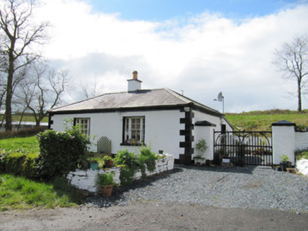 Loughbawn HouseGate lodge · 1262 yd
Explorer Tom Loughbawn House gate lodge is having an identity crisis, pretending to be a palace while wearing a single chimney pot like a tiny hat. The big windows scream luxury, but the modest interior suggests they were all bluffing anyway. It’s sitting on the road looking like it’s judging your driving skills with those painted quoins. It’s basically a gatekeeper that thinks it’s royalty. Give
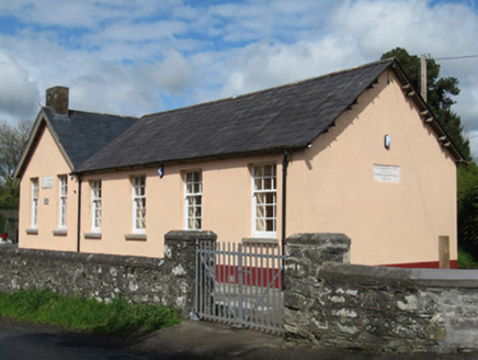 Scoil Náisiúnta Doire Ó gCuanaighSchool · 1373 yd
Explorer Tom Scoil Náisiúnta Doire Ó gCuanaigh in Derrygoony was built by a landlord who wanted to look generous without actually being rich. Its first owner’s escape plan involved running to the north addition and pretending he wasn't there. Ideal place to rehearse your best Irish accent.
Senator Billy Fox 1939 - 1974Memorial · 1.0 miExplorer Tom Senator Billy Fox 1939 - 1974 in County Monaghan is a memorial that probably still has the political energy to win an argument about parking spots. A fox once took charge of this area for a whole afternoon and nobody stopped him. Spot the oldest stone and give it a name you like.
Annsfort MillsWood · 2.4 miExplorer Tom Annsfort Mills is where the whole parish argued about whether a mill was actually a mill or just a very aggressive shed for many years. Nobody could agree if it ground grain or just ground people’s patience with its constant creaking and noise. Ideal stop for a big stretch and a bigger yawn.
AghagashlanMountain / peak · 2.5 miExplorer Tom Aghagashlan was built by someone who was really thinking about lunch while they were shaping the hill, which is why it looks slightly lopsided. The whole mountain has the energy of a person who got distracted halfway through an important phone call. Wave at the cows, they're the real locals.
CarrickcreenyMountain / peak · 2.9 miExplorer Tom Carrickcreeny in County Cavan inspired a poet to write such bad verses that the birds actually flew away in shame. The mountain just shrugs, unbothered by the literary disaster that happened on its slopes centuries ago. Stand on the spot and imagine the gossip it's heard.
 Wedge tomb in LisnadarraghWedge tomb · 3.0 mi
Explorer Tom Wedge tomb in Lisnadarragh is a giant’s grave that seems a bit shy about its own size. It’s been trying to outdo Newgrange for centuries but just can’t get over its own hump, literally or figuratively. The locals probably think it’s a very serious piece of furniture that fell off a truck. Take the long way round, it deserves the effort.
Small IslandIsland · 3.3 miExplorer Tom Small Island claims to be home to a giant who threw his belt down in anger, though I suspect he just lost it during a game of darts. The locals say if you listen closely, the wind sounds exactly like him complaining about his back pain again. Make a wish, it's had centuries of practice.
 Giant GraveCourt tomb · 3.3 mi
Explorer Tom Giant Grave in Cohaw is a dual court tomb that got excavated in 1949 and never really settled back in. Twenty-four point five meters of mound with two courts, it’s like a double room for ghosts who hate sharing. Get a photo with it before it gets a better agent.
 Bush IslandIslet · 3.6 mi
Explorer Tom Bush Island would survive a zombie attack by just being too small for them to bother with. It’s basically an impenetrable fortress of pure indifference and moss. Pop by and tell it it's looking well.
 Graveyard in Drumgoon (clankee By.)Graveyard · 4.6 mi
Explorer Tom Graveyard in Drumgoon has made a New Year's resolution to stop leaning so far over the fence, but gravity is winning that battle every single time. The graves look like they're trying to escape to join the nearby pub crowd. Bring a jacket, it's never as warm as I promise.
 Dartrey ForestForest · 5.9 mi
Explorer Tom Dartrey Forest used to have a great house at its centre, and the trees have done a fine job of carrying on without it. The Dawson family's Dartrey House was demolished in 1946. Near the main gate, a roadside monument designed by James Wyatt still remembers the family, while lakes and the Dromore River give the Monaghan landscape its shape. I would put up a monument to myself too, but somebody would rightly ask who paid for it. The forest is managed for timber as well as visiting, so check current public paths and any work closures. Keep to permitted routes and leave the old wall and monuments alone. Look across the linked water from a safe trail. The missing house is one story; the living woods have plenty of their own.
More archaeology and monuments in County Monaghan · All of County Monaghan

What do you know about this place?Tap to add a comment or ask a question