
What is recorded here
From the National Monuments Service (Archaeological Survey of Ireland) record MA109-001
Places near here
Photo credits
- Maker not stated on source page, ie.pinterest.com
- National Inventory of Architectural Heritage
- Maker not stated on source page, www.pinterest.com
- Maker not stated on source page, www.dreamstime.com
- Maker not stated on source page, www.flickr.com
- Maker not stated on source page, commons.wikimedia.org
- Maker not stated on source page, www.mayo-ireland.ie
- Maker not stated on source page, www.nationalparksatnight.com
 Bilberry IslandCrannog · 728 yd
Explorer Tom Bilberry Island has had so many names it’s lost count and just picked this one. It’s a bit shy about its previous…
 kiln1143 yd
Explorer Tom The kiln in Furnace is proud of one thing: it never caught fire itself. It just watched everyone else panic while it…
 Castle IslandCrannog · 1701 yd
Explorer Tom Castle Island in Portroyal is named after a castle but feels like it’s just pretending to be one, sitting there on a…
 Derry IslandCrannog · 1.0 mi
Explorer Tom Derry Island is playing hard to get, hiding out in Lough Mask like it’s got a secret. Legend says it would spill its…
 Fairy fort / stone ringfort in PortroyalFairy fort / stone ringfort · 1.1 mi
Explorer Tom Fairy fort / stone ringfort in Portroyal is on an island, which makes parking rights a total nightmare for the fairies.…
 Birds IslandCrannog · 1.1 mi
Explorer Tom Birds Island claims to be older than the birds currently arguing on top of it. It’s a crannog that thinks it’s a…
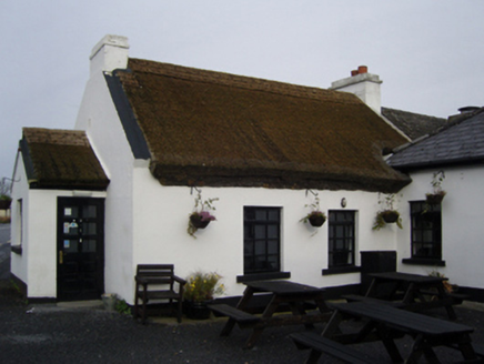 The Village InnFarm house · 1.1 mi
Explorer Tom The Village Inn has strong opinions on modern buildings, thinking they’re all just tin cans with delusions of grandeur.…
 Castle (ruin)Castle, unclassified · 1.3 mi
Explorer Tom Castle in Ballynaslee is just sitting there being mysterious while the seagulls probably call it 'The Big Stone Pile'…
 Curlew IslandIslet · 1.5 mi
Explorer Tom Curlew Island has an imaginary twin across the sea that they argue with every sunset. It’s named after a bird, but…
 Ballyovey CemeteryGraveyard · 1.7 mi
Explorer Tom Ballyovey Cemetery in County Mayo exists because the map makers got so confused they just drew two lines instead of…
 Church IslandIslet · 2.3 mi
Explorer Tom Church Island is out here doing the 'I'm holy, don't touch' routine very effectively. It reviews its visitors as…
 CastleCastle, unclassified · 2.6 mi
Explorer Tom Castle in Cloonlagheen was built on a bargain so good it made the lawyers cry. The Abbe MacEnville probably traded a…
More archaeology and monuments in County Mayo · All of County Mayo

What do you know about this place?Tap to add a comment or ask a question