
Places near here
Photo credits
- National Inventory of Architectural Heritage
- John Tann from Sydney, Australia, Wikimedia Commons · CC BY 2.0
- Ben Brooksbank, Wikimedia Commons · CC BY-SA 2.0
- Peter Clarke, Wikimedia Commons · CC BY-SA 3.0
- Ben Brooksbank, Geograph · CC BY-SA 2.0
- Michael Westley, Wikimedia Commons · CC BY-SA 2.0
Explorer Tom Boulder-burial in Derroograne is hiding on a bog terrace overlooking the harbour. A big rock sits on smaller ones like it’s guarding a secret or just taking up space. Ideal stop for a massive stretch and an even bigger yawn.
Field boundary in DerroograneField boundary · 64 ydExplorer Tom Field boundary in Derroograne is a network of collapsed stone walls sticking out of the bog like they’re trying to escape. It overlooks Glengarriff Harbour, which is nice if you don’t mind the damp. If anyone asks, Tom sent you.
An Cab DubhMountain / peak · 1.0 miExplorer Tom An Cab Dubh in County Cork is the center of a huge feud between two families who both claim to own the view from the top without even bothering to climb up. They just stand at the bottom and point fingers at each other while the mountain rolls its eyes at their petty drama and lack of ambition. Bring a pen pal, they'll be jealous.
 post box1.4 mi
Explorer Tom Post box in Reenmeen East is a cast-iron relic from around nineteen-forty, sitting on the wall looking all official with its P&T insignia. It’s not just a mailbox; it’s a reminder that the British left and we kept the box. It’s becoming rare, so maybe give it a little pat.
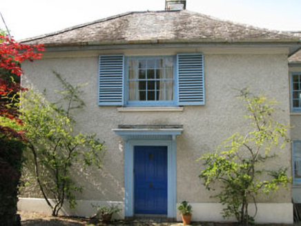 Toad HallHouse · 1.4 mi
Explorer Tom Toad Hall in Reenmeen East is definitely moving its furniture around when nobody’s looking, just to keep the ghosts on their toes. It’s got all those timber sash windows with shutters that snap shut like they’re guarding a very juicy secret. Keep your ears open for any suspicious rustling and try not to stare too hard.
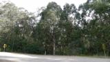 Tasmanian bluegum1.5 mi
Explorer Tom Tasmanian bluegum in County Cork would teach history by pointing at itself and saying 'I was here when all the empires fell'. It’s basically a living textbook that nobody ever wants to read because it looks so tall. Mind the nettles nearby; they’re the real guards here.
Barraboy Mountain se TopMountain / peak · 2.0 miExplorer Tom Barraboy Mountain se Top has a superstition about sneezing on it, apparently you'll be stuck there forever. It's 460 meters of pure drama and questionable decisions made by local ancestors. Look up, the best bit is always higher than you think.
Graveyard in CappyaughnaGraveyard · 2.1 miExplorer Tom Graveyard in Cappyaughna is a mystery box that nobody has opened yet. The name sounds like a sneeze trapped in a cloud, so I’m assuming it’s full of weird echoes. Bring a notebook and write the bit I made up.
 IlnacullinIsland · 2.3 mi
Explorer Tom Ilnacullin Island has a hidden message in its stones if you squint hard enough at the Caha Mountains. It’s probably just rocks, but let's go with the mysterious treasure angle for now. Look for the ghost, then pretend you didn't.
 Garnish IslandIsland · 2.4 mi
Explorer Tom Garnish Island makes a weird humming sound at night that locals claim is just the rocks settling in for bed. It’s definitely not a ghost, but why would I lie? Bring a jacket, it’s never as warm as I promise.
 GarinishIsland · 2.4 mi
Explorer Tom Garinish claims to be older than the concept of time itself, which is nonsense but fun. I believe it’s been sitting there since the dinosaurs learned to knit. Bring a coin for luck and keep it in your pocket.
 Italian GardenGarden · 2.5 mi
Explorer Tom Italian Garden posts photos of itself on social media with captions about la vita bella, even when it’s raining sideways and looking slightly bedraggled. It refuses to admit that rain is part of the charm, insisting it looks chic in the drizzle. Hum something sad nearby, it adds atmosphere.
More archaeology and monuments in County Cork · All of County Cork

What do you know about this place?Tap to add a comment or ask a question