Places near here
Photo credits
- National Inventory of Architectural Heritage
- RTG, Wikimedia Commons
- Suse, Geograph · CC BY-SA 2.0
- Stephan van Helden, Wikimedia Commons · CC BY-SA 4.0
- abdallahh from Montréal, Canada, Wikimedia Commons · CC BY 2.0
- Oliver Dixon, Geograph · CC BY-SA 2.0
- jbraine, Wikimedia Commons · CC BY 2.0
Explorer Tom Megalithic structure in Ballyformoyle is a sunken area defined by sandstone and limestone slabs that was thought to have rock art but didn't, which is its least favourite visitor: disappointment. It’s been investigated since the 19th century and still looks like a broken toy. Bring your nan, she'll know more than me.
IndicatedFairy fort / earthen ringfort · 1.1 miExplorer Tom Behy’s ringfort is having a massive grudge against the wind, which has been picking at its ears for centuries. It looks like a donut that got tired of being eaten by history. Bring the dog, it'll have opinions.
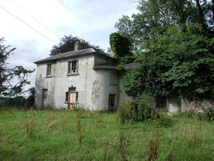 Knockranny HouseCountry house · 1.7 mi
Explorer Tom Knockranny House is derelict but still looking impressive with its bowed gable and full-height windows overlooking Lough Meelagh. The whole parish used to argue about whether it was too fancy or not, which is why nobody lives there now. It’s a beautiful mess that probably hasn’t had a proper dusting in decades.
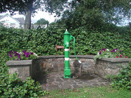 Nanny's WellOfficially recorded historic building · 1.7 mi
Explorer Tom Nanny's Well in Keadew West looks like it has better taste than most humans, with all that fancy fluting and banding. Legend has it a goat ruled this place for a decade before anyone had the sense to build a proper well around its ego. Stand there and look impressed by the stonework.
Turlough O'CarolanMemorial · 1.8 miExplorer Tom Turlough O’Carolan Memorial is guarding a tunnel that leads straight to the best pub in town, provided you know the secret knock, which is a slurp. He’s got more songs than a radio station and twice the charm of a damp sock. Go before the tourists find out it’s actually just a statue.
 Arigna Mining ExperienceHeritage attraction · 3.7 mi
Explorer Tom Arigna Mining Experience will cure me of saying a job is cramped when I merely cannot find my keys. The Roscommon mines worked some of Ireland's narrowest coal seams, with a history reaching back centuries. Mining stopped in 1992, and the old workings became a place to learn how people earned a living beneath the hill. Arigna iron also went into Dublin's Ha'penny Bridge, a surprising connection between a dark mine and a bright city landmark. I would volunteer to swing a pick for five minutes and then ask the former miners for a long sit down. Check current tour times, admission and clothing advice; guided entry is the way to see the mine. Listen closely to the accounts of the workers. Their skill did far more than feed a furnace.
 Castle IslandIslet · 4.0 mi
Explorer Tom Castle Island thinks all tourists from Dublin are just here to take selfies and ignore the actual history of the place, which frankly makes me angry too. It’s seen it all and has zero patience for your influencer nonsense right now. Bring a flask and pretend you own the place.
 Horse-chestnut4.4 mi
Explorer Tom Horse-chestnut in County Roscommon was once a matchmaker for local couples who wanted to prove their love was as strong as its fruit. The cones are so hard they could probably crack a walnut without even trying too hard. Bring a flask of something warm and a story to swap.
 Western Redcedar4.4 mi
Explorer Tom Western Redcedar in County Roscommon would want 'Finally Tall Enough' on its tombstone because it spent centuries growing only to be outdone by the clouds, which is a tragedy that really sticks in the ribs of any ambitious conifer with big dreams. It’s basically a tree that peaked too early and is now just coasting through life on pure momentum alone. Tell the kids it's a castle. Close enough.
 Shannon-Erne WaterwayVisitor information · 4.6 mi
Explorer Tom The Shannon-Erne Waterway was the result of a bad bet between two kings who couldn't agree on which river was more important, so they just dug through everything to prove a point. It’s a canal that feels like it’s still waiting for an apology. Tell it a joke, it's been a long time since anyone did.
 Hog's IslandIslet · 4.6 mi
Explorer Tom Hog’s Island in County Roscommon sounds like the place where pigs go to hide from the butcher, but it’s probably just a rock. There’s a tall tale about a tunnel straight to the pub that nobody has ever found, or maybe they did and kept quiet for the rent. Look for the ghost, then pretend you didn't.
 Lough Key Forest ParkWood · 4.9 mi
Explorer Tom Lough Key Forest Park can keep you busy for a day, then leave me insisting we missed half of it. The Roscommon grounds cover around 800 hectares along the lake. Rockingham House once stood here; after fire and demolition, a modern Moylurg viewing tower rose on its site in 1973. Even old service tunnels from the estate remain nearby. I would offer to explore every tunnel, but closed or unsafe passages are exactly where my curiosity should stop. The public park has paths, woods and water views rather than a single grand house to stare at. Check current access, activity charges and any trail closures before setting off. Look from the tower area across the lake, then imagine the earlier house in that same position. One estate became a much wider invitation to wander.
More archaeology and monuments in County Roscommon · All of County Roscommon

What do you know about this place?Tap to add a comment or ask a question