
Places near here
Photo credits
- JP, Geograph · Creative Commons Attribution-ShareAlike 2.0
- Miguel Angel Masegosa Martínez, Wikimedia Commons · CC BY 2.0
- Britishfinance, Wikimedia Commons · CC BY-SA 4.0
- National Inventory of Architectural Heritage
- Vicente Fernández Rioja, Wikimedia Commons · CC BY-SA 4.0
- Marathon, Wikimedia Commons · CC BY-SA 2.0
- Sheila1988, Wikimedia Commons · CC0
- Schcambo at English Wikipedia, Wikimedia Commons · Public domain
- Joe King, Wikimedia Commons · CC BY-SA 3.0
- P L Chadwick, Wikimedia Commons · CC BY-SA 2.0
- Simon Mortimer, Geograph · CC BY-SA 2.0
 Saint Patrick's Catholic ChurchChurch/chapel · 365 yd
Explorer Tom Saint Patrick’s in Curtlestown was once marked as St Kevin’s on the maps, so it has serious identity issues. It sits proudly on a rise, humming “I Will Always Love You” because it feels abandoned by history. Snap a photo of its confused face for me.
 Sweet Chestnut1657 yd
 Prince William's SeatMountain / peak · 1.2 mi
Explorer Tom Prince William’s Seat would ace a job interview by claiming it invented the concept of standing still. Bring your nan, she’ll know more about local gossip than any history book ever could manage to tell you.
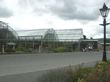 Powerscourt HouseShop/retail outlet · 1.3 mi
Explorer Tom Powerscourt House in Powerscourt Demesne, County Wicklow, is the gift shop that would bring a laser light show to any party. It’s modern right next to a grand mansion, which is like wearing sneakers with a tuxedo. Stare at its bold choice!
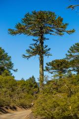 Monkey-puzzle1.3 mi
Explorer Tom Monkey-puzzle in County Wicklow has developed a deep suspicion of the postman, possibly because he once dropped a parcel on its roots. It stands there looking like it’s waiting for an apology that will never come. Dare you to say hello to it out loud.
 Julia's MemorialSculpture · 1.4 mi
Explorer Tom Julia's Memorial is quietly wondering what it would do with a lotto win, probably buy a very expensive hat for itself. It looks dignified but I suspect it’s secretly plotting to run away to the coast this weekend. Ring your granny and tell her where you are exactly.
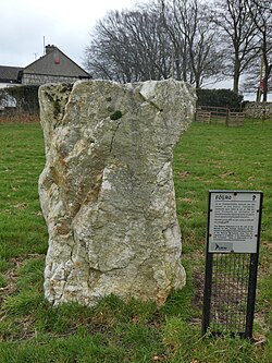 Glencullen Standing StoneArchaeological place · 2.1 mi
Explorer Tom Glencullen Standing Stone in County Dublin actually means 'The Spot Where I Forgot My Keys In 1200' if you ask me, which is probably close enough. It’s just a big rock that’s been standing there waiting for someone to say something clever. Ideal place to rehearse an excuse for being late.
 MaulinMountain / peak · 2.4 mi
Explorer Tom Maulin stands above Powerscourt Waterfall, so I could say it has a grand shower at the foot of the hill. At 570 metres, it is a popular Wicklow summit reached by trails from Crone Woods and near the Wicklow Way. More ambitious walkers use it on the roughly sixteen-kilometre Glensoulan circuit with Tonduff, War Hill and Djouce. I would announce the full loop and then spend ten minutes looking for my water bottle. The forestry paths can give way to exposed hill ground, so check the route, weather, parking and any trail works before setting out. Stay clear of steep drops above the waterfall. Look back towards the wooded valley as you gain height. It is a fine reminder that a moderate number on a map can still mean a proper day outside.
 Ballyedmonduff Wedge TombArchaeological place · 2.7 mi
Explorer Tom A fox once took charge of this wedge tomb and I think he still runs the place. The stones are just along for the ride now. Bring your worst joke, the place has heard worse.
 Powerscourt WaterfallVisitor attraction · 3.0 mi
Explorer Tom Powerscourt Waterfall in County Wicklow is hoarding a century-old scandal about a secret kiss right behind that roaring curtain of water. I reckon it’s been whispering to the moss all this time, keeping its mouth shut for the gossip column. Have a chat with it, nobody's watching.
 Deerpark TrailWalking route · 3.2 mi
Explorer Tom Deerpark Trail is absolutely showing off its muscles in County Wicklow. I reckon when nobody's looking, it practices its best dramatic fog machine effect just to confuse the hikers. Ideal for a moody photo you'll pretend wasn't posed.
 Fairy CastleArchaeological place · 3.6 mi
Explorer Tom Fairy Castle is an archaeological place that sounds like a bedtime story but feels like a headache. It’s somewhere in County Dublin, probably hiding from the tourists. Don’t let the fairies know we’re looking for them!
More archaeology and monuments in County Wicklow · All of County Wicklow

What do you know about this place?Tap to add a comment or ask a question