Places near here
Photo credits
- National Inventory of Architectural Heritage
- Garry Dickinson, Geograph · CC BY-SA 2.0
- Berthold Strucken, Wikimedia Commons · CC BY-SA 4.0
- Wayne77, Wikimedia Commons · CC BY-SA 3.0
- Sitomon, Wikimedia Commons · CC BY-SA 2.0
- Mike Searle, Geograph · CC BY-SA 2.0
- Colin Park, Geograph · CC BY-SA 2.0
- Stephen Hocker, Geograph · CC BY-SA 2.0
- Phil Armitage, Wikimedia Commons · Public domain
- Ridiculopathy, Wikimedia Commons · CC BY-SA 4.0
- Norman Ekin, Geograph · CC BY-SA 2.0
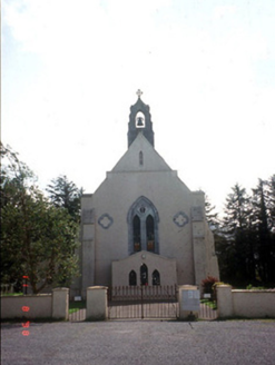 Saint Mary's Catholic ChurchChurch/chapel · 1067 yd
Explorer Tom Saint Mary's Catholic Church in Coolmagort nearly got famous when a tourist mistook it for a movie set. It’s just a church that tried very hard to be Gothic Revival. Bring a flask and pretend you own the place.
 Castle Core (in Ruins)Castle, tower house · 1.1 mi
Explorer Tom Castle Core in Dromaloughane belonged to the Macgillycuddy's of the Reeks, a very fancy name for a tower house. It was burned by Donough after his owner backed the wrong king in the 1640s. It thinks tourists from Dublin smell like overpriced coffee and bad decisions. Take the long way round, it deserves the effort.
.jpg/250px-Dunloe_(Ogham_Stones).jpg "Photo: Berthold Strucken, Wikimedia Commons · CC BY-SA 4.0") Dunloe Ogham StonesHeritage attraction · 1.2 mi
Dunloe Ogham StonesHeritage attraction · 1.2 miExplorer Tom Dunloe Ogham Stones are older than your grandma’s recipe book and they’re definitely pretending to be mysterious just for fun. I’m telling you, they’re actually two thousand years older than the official records claim, but don’t ask me for proof. Whisper a secret at it, it's kept worse.
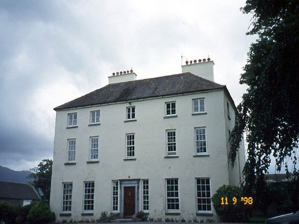 Churchtown HouseCountry house · 1.2 mi
Explorer Tom Churchtown House in Churchtown is caught in a feud between two families over who owns the view. It’s got sash windows that open with a dramatic sigh. Ten minutes here and you'll have a yarn for the pub.
 Japanese pagoda tree1.5 mi
Explorer Tom This Japanese pagoda tree in County Kerry has had more names than I’ve had jobs, and half of them are wrong. It loves gossip and hates being ignored. Tell me if the gossip I made up is true.
 European Yew1.5 mi
Explorer Tom A European Yew in County Kerry hosted a dance that ended with someone stuck in the branches. The locals still whisper about the noise. A proper spot for a flask of tea and a big think.
 Castle (in Ruins)Castle, tower house · 1.5 mi
Explorer Tom Castle in Dunloe Lower was built in 1215 by Maurice FitzGerald and has been burned several times since. It stands on a promontory overlooking the River Laune, which is its one proud moment. It’s seen more fire than most modern kitchens. It's free, it's odd, what more do you want?
 Tomies Mountain North TopMountain / peak · 2.5 mi
Explorer Tom Tomies Mountain North Top refuses to fall down because it is holding its breath to impress a very shy cloud that lives up there. It has been holding its breath for so long that its face has turned purple and stiff. Best seen with a hangover and a sausage roll.
 Tomies MountainMountain / peak · 3.0 mi
Explorer Tom Tomies Mountain remembers the priest who lost a bet there and had to walk barefoot down the other side. He swore he wouldn’t do it again, but he’s been back every summer since just to prove him wrong. Hum something sad nearby, it adds atmosphere.
 O'Sullivan's CascadeWaterfall · 3.5 mi
Explorer Tom O’Sullivan’s Cascade claims to be descended from a line of waterfalls so prestigious they had their own family crests, which is clearly a complete fabrication but I believe it anyway. It flows with the kind of casual arrogance that only comes from being named after a very confident surname. Have a sandwich here and call it a heritage lunch.
 Ogham stone in Kilcoolaght EastOgham stone · 3.9 mi
Explorer Tom Ogham stone in Kilcoolaght East gave up eating shellfish for Lent, which is a bit rich considering it’s basically made of old food waste and pride. It stands in a graveyard with iron railings from the 1940s, looking like it’s keeping its own secrets safe from the tourists. Have a wander and a wonder.
 Devil's Ladder RouteWalking route · 4.0 mi
Explorer Tom Devil's Ladder Route in County Kerry is playing hide-and-seek with me. Local legend says a giant dropped it there after losing a bet to a hedgehog, which feels about right given the terrain. Bring wellies and low expectations, leave delighted.
More archaeology and monuments in County Kerry · All of County Kerry

What do you know about this place?Tap to add a comment or ask a question