
What is recorded here
Situated in a graveyard (DU025-003005-) on a steep grass-covered knoll, off the Pine Forest Road. A cemetery watchtower built to prevent the robbery of freshly dug graves which consists of a two storey high cylindrical tower (ext. diam. 3.2m), with a parapet level marked by an offset. It is built of roughly coursed…
Read the whole record
From the National Monuments Service (Archaeological Survey of Ireland) record DU025-003003
Places near here
Picture notes
- National Inventory of Architectural Heritage
- Computer-made picture. It does not show this monument.
- Alan James, Geograph · CC BY-SA 2.0
- Sarah777, Geograph · CC BY-SA 2.0
- Computer-made picture. It does not show this walking route.
- Joe King, Wikimedia Commons · CC BY-SA 3.0
- Computer-made picture. It does not show this playground.
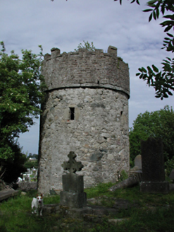 graveyard/cemetery1 yd
Explorer Tom Graveyard or cemetery in Cruagh has a watch-tower built specifically to stop body snatchers from stealing the dead for science. That is either very clever or deeply paranoid, and honestly, I can't decide which. It's frightfully quiet, so don't make a sound unless you want to be next!
 Font in CruaghFont · 8 ydComputer-made picture
Explorer Tom Font in Cruagh. This roughly square granite font sits in the graveyard, near a vanished pillar stone with concentric circles. It’s curious to hold a basin from centuries ago while knowing its stone neighbor has already disappeared.
 Inscribed stone in CruaghInscribed stone · 8 ydComputer-made picture
Explorer Tom Inscribed stone in Cruagh is missing from its graveyard spot on a steep knoll. Once had concentric circles carved into it, now it's just a gap in the history books. Dr. Petrie drew it back in 1816, so it existed!
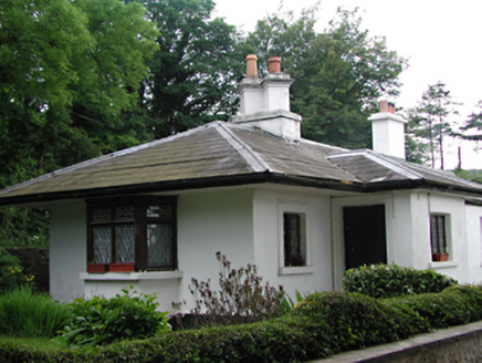 Killakee HouseGate lodge · 310 yd
Explorer Tom Killakee House in Cruagh was a gate lodge that evicted Lady Massy, which gives it quite the drama to lean on. It’s pretty and standing at a fork in the road, probably plotting her comeback all this time.
 Massey WoodWood · 1425 yd
Explorer Tom Massey Wood in County Dublin has ruins of a garden and saw mill. Lord Massey built it, then it broke. Classic. The Dublin Mountains Way goes through here, so follow the path!
 Pine ForestForest · 1695 yd
Explorer Tom Pine Forest in County Dublin saw a white Christmas back in 2004. The pines were probably freezing their needles off. Bring a hat if you want to survive.
 Dublin Mountains Way Hellfire & Massey SpurWalking route · 1.2 miComputer-made picture
Explorer Tom The Dublin Mountains Way Hellfire & Massey Spur again in County Dublin, it's becoming a bit of a theme. I bet the 'hellfire' is just the sun beating down on your head. Stay hydrated and ignore the overly dramatic trail markers.
 Montpelier HillMountain / peak · 1.2 mi
Explorer Tom Montpelier Hill is famous for the Hell Fire Club at dawn. The sun comes up over it in a mysterious way, so watch the light change and pretend you’re about to make a dangerous pact with a devil.
 Children's playground1.3 miComputer-made picture
Explorer Tom Children's playground in County Dublin is probably full of mischief. A local tale says if you drop a coin here, you’ll find a better one somewhere else. Go test this theory!
 Marley PlaygroundChildren's playground · 1.4 miComputer-made picture
Explorer Tom Marley Playground in County Dublin is probably just a big pile of marbles and mysteries. I heard the sandpit is actually a portal to another dimension. Step carefully, you might fall through!
 KilmashogueMountain / peak · 1.5 mi
Explorer Tom Kilmashogue is part of the Dublin Mountains and looks great from the southeast. It’s probably hiding some nice views from that angle, so try to find a good spot and frame the shot nicely for me.
 Calbeck CastleRuins · 1.8 mi
Explorer Tom Calbeck Castle is a ruin that forgot to tell anyone it was leaving. It’s all rubble and regret near Kilmashogue. If you find it, don’t let it know I’m calling it a pile of old bricks.
More archaeology and monuments in County Dublin · All of County Dublin

What do you know about this place?Tap to add a comment or ask a question