Places near here
Photo credits
- National Inventory of Architectural Heritage
- Willow, Wikimedia Commons · CC BY 2.5
- Enda O Flaherty, Geograph · CC BY-SA 2.0
- Niallio77, Wikimedia Commons · CC BY-SA 3.0
- Maelor at English Wikipedia, Wikimedia Commons · Public domain
- GTD Aquitaine, Wikimedia Commons · Public domain
- Djedi Guy, Wikimedia Commons · CC BY-SA 4.0
- Oliver Dixon, Geograph · CC BY-SA 2.0
- Andreas F. Borchert, Wikimedia Commons · CC BY-SA 4.0
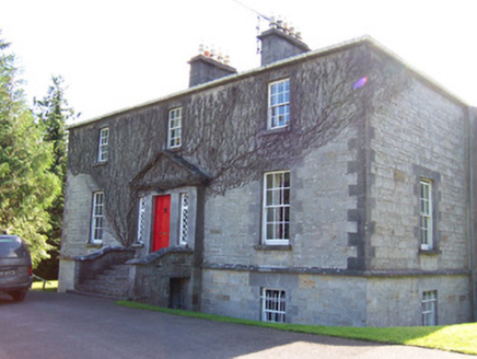 Toberfeckin HouseRectory/glebe/vicarage/curate's house · 1.3 mi
Explorer Tom Toberfeckin House in Barnabrack has a prophecy saying it will float away on Tuesday, which never happened. Its diamond panes are just waiting for someone to break them. Keep your eyes peeled for the pediment, mate.
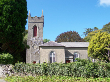 Christ Church (Dromard)Church/chapel · 1.5 mi
Explorer Tom Christ Church in Dromard would tell you in a job interview that it has excellent interior furniture, great window traceries, and zero patience for people who don’t appreciate quiet wooded landscapes. It’s set beautifully in the trees with a school house and graveyard full of carved headstones that have stories to tell. Listen closely to the wind through the pines.
 European ash2.1 mi
Explorer Tom European ash in County Sligo handles nosey neighbours by simply dropping a leaf directly on their heads every single time they look up. It’s a small act of defiance, but effective. Tell the kids it's a castle. Close enough.
 The GlenWood · 3.7 mi
Explorer Tom The Glen in County Sligo is where the seagulls hold their weekly board meetings about how to annoy the tourists most effectively. They really think they run this place, so you might as well let them. Mind the nettles, they're the real guards here.
 CulleenamoreBeach / strand · 4.0 mi
Explorer Tom Cullenamore would survive a zombie apocalypse purely because nobody knows where it is, so the undead just get lost in the sand. It's got that quiet confidence about it, like it's waiting for someone to finally notice its brilliance. Wave at the cows, they're the real locals.
 Miosgan MevaPassage tomb · 4.3 mi
Explorer Tom Miosgan Meva is the big brother on Knocknarea, sitting there like a giant stone bread loaf that nobody wants to eat. Its plan for retirement is to sit exactly where it is and let tourists trip over themselves trying to take photos. It’s got a flat top that looks like it was made for sunbathing by ancient kings. Bring the dog, it'll have opinions.
Queen Medb's Cairn: KnocknareaLegend location · 4.4 miExplorer Tom Queen Medb's Cairn: Knocknarea sits high on the mountain, and legend gives it a queen for an occupant. It is an enormous cairn. Whoever first tied Medb to it clearly had no interest in a modest ending to her story.
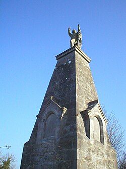 Battle of CollooneyBattle · 4.7 mi
Explorer Tom The Battle of Collooney in County Sligo took about four cups of tea to build up the energy needed for the fighting, and they used them all up. Bartholomew Teeling put up a monument there, which is basically a giant finger wagged at history for forgetting this little scuffle. Stop the car, it's worth the hazard lights.
 Battlefield in Carricknagat (leyny By.),rinn (leyny By.),bleachgreen,collooney,ardcottenBattlefield · 4.7 mi
Explorer Tom Battlefield in Carricknagat survived a massive storm by just staying put, which is impressive for a spot with such a chaotic history of conflict and confusion. It’s got a real 'I’ve seen it all' attitude that makes you feel like your problems are tiny in comparison to the old wars. Go at sunset and thank me later.
 Teeling MonumentMemorial · 4.7 mi
Explorer Tom The Teeling Monument refuses to fall down because it’s too proud to admit the ground beneath it is just soft mud. It stands there looking smug, like it owns the whole of Collooney and knows secrets it won’t share. Give it a pat on the way past, it's had a long life.
 Strandhill BeachBeach / strand · 4.9 mi
Explorer Tom Strandhill Beach is currently in a massive feud with the rain, claiming it’s the real king of the coast. The dunes are just standing there judging both sides like tired grandparents. Tell the next person you meet it's haunted. It might be.
 ListoghilPassage tomb · 5.0 mi
Explorer Tom Listoghil in Carrowmore has an imaginary twin across the sea that sends it postcards with no return address, which is why it’s so confused right now. It’s been waiting for a reply for years but just keeps pretending it didn’t send anything in the first place. Bring someone who'll believe anything.
More historic places in County Sligo · All of County Sligo

What do you know about this place?Tap to add a comment or ask a question