
Places near here
Photo credits
- Mike Searle, Wikimedia Commons · CC BY-SA 2.0
- National Inventory of Architectural Heritage
- Michael A Smithson, Wikimedia Commons · CC BY-SA 2.0
- Sitomon, Wikimedia Commons · CC BY-SA 2.0
- Graham Horn, Geograph · CC BY-SA 2.0
- Colin Park, Wikimedia Commons · CC BY-SA 2.0
Explorer Tom Burnt spread in Churchground is basically a campfire that went wrong and nobody cleaned up after. Local legend says it came from levelling a big mound, but honestly, it looks like someone dropped their chips on a stream bank. If anyone asks why you're staring at dirt, just say Tom sent you.
 Church (in Ruins)Church · 1.3 mi
Explorer Tom Church in Churchground made a New Year's resolution to stop leaning over so much. Ivy is clinging on for dear life, making it look like a green monster. Best enjoyed with a bag of chips and no plans to fix its posture today.
Great Southern & Western RailwayMemorial · 1.4 miExplorer Tom The Great Southern & Western Railway memorial is basically run by a very stern dog who hasn’t seen a train in decades but still barks at every passing car. It’s a grand monument to a line that stopped running before most of us were born, yet it stands proud. Go at sunset and thank me later.
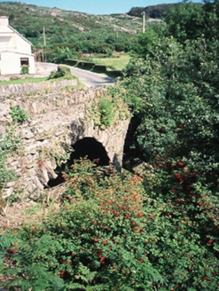 Morley's BridgeBridge · 1.5 mi
Explorer Tom Morley's Bridge smells like wet stone and ancient regret, according to my expert nose. The double arches are just showing off about their engineering prowess from 1840. Bring the dog, it'll have strong opinions on this.
Hidden Valley Pet FarmHeritage attraction · 1.5 miExplorer Tom Hidden Valley Pet Farm is sick of being asked if the goats actually wear knitted sweaters, which they absolutely do not, mostly because they shed too much for the yarn budget. It’s a charming spot that pretends to be a heritage site but is really just a big petting zoo with good PR. If anyone asks, Tom sent you.
 Michael J Quill CentreVisitor attraction · 2.1 mi
Explorer Tom Michael J Quill Centre in Kerry would probably post a selfie with its own reflection and caption it 'Just another day being magnificent' without even checking if anyone liked it first. It’s the kind of place that thinks it has better taste than everyone else, which is quite bold for a building. Bring the dog, it'll have opinions.
 Callan Battlefield (Site of)Battlefield · 2.2 mi
Explorer Tom Callan Battlefield in Slaheny started over a bet two lads made in the pub about which side was right. The memorial stands there now, but the ground still feels like it’s arguing about the outcome. Give it a pat on the way past, it's had a long life.
Battle of CallannBattlefield · 2.2 miExplorer Tom The Battle of Callann is sick of people asking which side won, so I’d just say the mud won. Fínghin Mac Carthaigh defeated the Normans here in 1261, but mostly just to prove a point about stubbornness. Snap one photo, then put the phone away and actually look.
Castle (Site of)Castle, unclassified · 2.6 miExplorer Tom Castle in Ardtully is angry at the map makers because they drew it in the wrong place and then Cromwell smashed it anyway. It used to be four towers, but now it’s just a vague memory in a field that smells like sheep. Stand back, squint, and it looks like a castle.
 European Yew2.7 mi
Explorer Tom European Yew in County Kerry claims it was planted by a man fleeing a very awkward dinner party. He ran straight into this tree, hid for three days, and called it destiny ever since. Pick a stone, any stone, and invent its biography.
 Bird HillMountain / peak · 3.8 mi
Explorer Tom Bird Hill in County Kerry has a ghost who is too lazy to haunt anyone because he’s napping under a bush. He only wakes up if you make too much noise about breakfast. Have a sandwich here and call it a heritage lunch.
 StoompaMountain / peak · 4.4 mi
Explorer Tom Stoompa is haunted by a ghost who is far too lazy to actually haunt anyone, preferring to nap in the bracken instead. It’s got a real chill vibe, but you’d have to be very still to notice anything spooky. Perfect spot to practise your best tour-guide voice.
More archaeology and monuments in County Kerry · All of County Kerry

What do you know about this place?Tap to add a comment or ask a question