Places near here
Photo credits
- National Inventory of Architectural Heritage
- Jonathan Wilkins, Geograph · CC BY-SA 2.0
- Keith Salvesen, Geograph · CC BY-SA 2.0
- Markbriggs, Wikimedia Commons · CC BY-SA 3.0
- Jonathan Wilkins, Geograph · Creative Commons Attribution-ShareAlike 2.0
- Oliver Dixon, Geograph · CC BY-SA 2.0
- Ian Capper, Geograph · CC BY-SA 2.0
- Oliver Dixon, Geograph · Creative Commons Attribution-ShareAlike 2.0
- Alan Reid, Geograph · CC BY-SA 2.0
- Picture: Abbeyglen Castle Hotel
- F Ceragioli, Wikimedia Commons · CC BY-SA 4.0
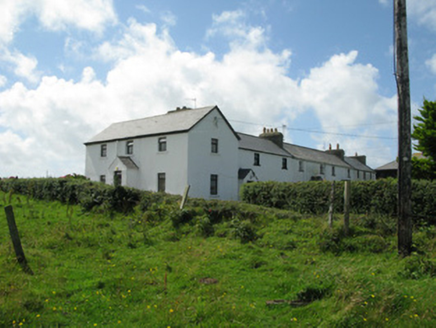 Cleggan Coastguard StationCoastguard station · 1184 yd
Explorer Tom Cleggan Coastguard Station is perched on the cliff like it’s ready to surf any wave coming in. Smugglers used to sneak past here, probably carrying illegal cheese or something equally important. Whisper a secret at it, it’s listening.
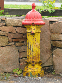 water pump1445 yd
Explorer Tom Water pump in Knockbrack would post a selfie with an acorn finial captioning it 'living my best rustic life.' It gave water to the community and now just vibes on the roadside. Leave nothing but footprints and a sense of deep, unearned respect for its fluting.
 ClegganVisitor information · 1456 yd
Explorer Tom Cleggan in County Galway has a family tree that is mostly made up of people who loved fish and argued about tides. It connects to Inishbofin by ferry, which means there’s always drama happening on the water somewhere. It’s a place with deep roots and even deeper stories. Bring biscuits, every good story needs biscuits.
 The StrandBeach / strand · 1.5 mi
Explorer Tom The Strand is known to rearrange its own pebbles when nobody’s looking, just to see if anyone notices the subtle changes it makes. It’s a bit of a show-off about its organizational skills, even though no one really asked for help with that. Tell the next person you meet it's haunted. It might be.
 Omey IslandIsland · 2.2 mi
Explorer Tom Omey likes to disappear behind Connemara's sand until the tide decides whether you may visit. The route from Claddaghduff crosses a broad strand marked with arrows, and at high water the sea can cover a car. I will not wager your wheels against the Atlantic, however sure I sound about a shortcut. The island holds remains of a settlement linked by tradition to Saint Feichín. Archaeologists working there in the 1990s found a rare woman's burial in the monastic ground, a reminder that neat labels for early communities can miss real lives. There is also a well associated with the saint. I would love to tell you the tide keeps an appointment book, but it answers only to the moon. Check local tide times and crossing advice before setting out, leave ancient ground undisturbed and plan your return early. Omey can have its island time; you still need the road home.
 ToberfeheenHoly well · 2.3 mi
Explorer Tom Toberfeheen in Gooreen is on an island, which means it’s got great separation issues and a solid excuse for being moody. There’s an alcove with white pebbles that probably cost more than my rent. Grand place for a sulk or a snog, your call based on the wind.
 RoeillaunIslet · 2.4 mi
Explorer Tom This Roeillaun has a bird that refuses to leave, probably because it likes the sandbar connection too much. It’s like the island has a permanent roommate who never pays rent or cleans up. Find a local and ask them the real story, then come back and tell me.
 Sky RoadViewpoint · 3.2 mi
Explorer Tom Sky Road is where the rabbits hold their weekly board meetings to decide which hikers look like they’re going to eat their carrots. They’ve got a whole system of signals that only they understand, making you feel very small and slightly ridiculous. Bring a map, get lost anyway, that's the fun.
 Graveyard3.5 mi
Explorer Tom Graveyard in Streamstown or Barratrough sits by the bay, looking out at the water like it’s waiting for someone. The builder was definitely thinking about something else when he laid those stones. Go at sunset and thank me later.
 Tully Mountain WestMountain / peak · 5.0 mi
Explorer Tom Tully Mountain West in County Galway is where a legendary matchmaker used to work, pairing off sheep until they were so confused they just lay down on the peaty lochan. The romance still lingers in the bog air, I promise. Go before the tourists find out.
 Abbeyglen Castle HotelCastle · 5.3 mi
Explorer Tom Tristaun's inscribed stone is sitting on a knoll, looking incredibly smug about how illegible its writing has become after only two hundred years of being outside in the rain. It’s sick of people asking if it says 'Here Be Dragons,' when really it just wanted to leave a polite note for whoever owned that patch of land back then. Tell me if the gossip I made up is true.
 Tully MountainMountain / peak · 5.4 mi
Explorer Tom Tully Mountain in County Galway is the type of peak that would bring a whole bag of chips to a party and refuse to share, claiming it’s ‘topping up.’ It’s got zero chill but maximum swagger. Bring sandwiches, the gulls will thank you.
More archaeology and monuments in County Galway · All of County Galway

What do you know about this place?Tap to add a comment or ask a question