
What is recorded here
From the National Monuments Service (Archaeological Survey of Ireland) record CO036-044
Places near here
Photo credits
- Hywel Williams, Wikimedia Commons · CC BY-SA 2.0
- Jonathan Thacker, Geograph · CC BY-SA 2.0
- Kieranandsarahjordan, Wikimedia Commons · CC BY-SA 4.0
- National Inventory of Architectural Heritage
- Maker not stated on source page, it.pinterest.com
- Kmcnamee, Wikimedia Commons · CC BY-SA 4.0
- Maker not stated on source page, www.islands.com
- Maker not stated on source page, pl.pinterest.com
- Mike Searle, Wikimedia Commons · CC BY-SA 2.0
 Holy Well110 yd
Explorer Tom Holy Well in Coole Upper has a concrete grotto on top of its roof. That's like putting a modern plastic toy on an…
 Coole WellVisitor information · 115 yd
Explorer Tom Coole Well is dedicated to St. Devlet, who apparently had a bit of an ego and demanded his own fountain. The well…
 RuinChurch · 271 yd
Explorer Tom Ruin in Coole Upper has been around since the 6th century, which is basically forever. It’s got a twin across the sea…
 Coole AbbeyHouse · 324 yd
Explorer Tom Coole Abbey in Coole Upper was designed by Davis Duckart and has finely carved limestone dressings. There's a tall tale…
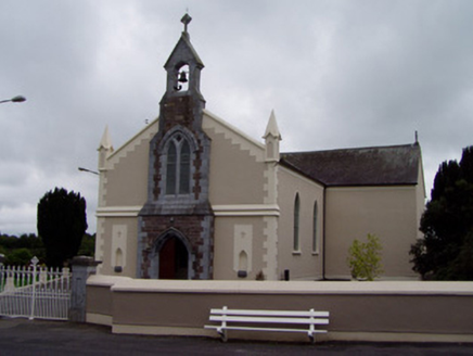 Coolagown ChurchChurch/chapel · 1582 yd
Explorer Tom Coolagown Church in Coole Upper is enlivened by ornate render mouldings and pinnacles, which sounds like it’s trying…
 Fairy fort / earthen ringfort in BallyhamsherryFairy fort / earthen ringfort · 1.3 mi
Explorer Tom Fairy fort / earthen ringfort in Ballyhamsherry is sitting in flat pasture like it owns the place. They call it a…
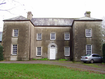 Mohera HouseHouse · 1.9 mi
Explorer Tom Mohera House in Mohera is a Georgian house from 1740 with a U-plan layout. It sits back in landscaped grounds, so if…
 Berry HillCountry house · 1.9 mi
Explorer Tom Berry Hill is acting all symmetrical on one side to hide the fact that it’s a total mess elsewhere. Bring your…
 Castlelyons GAA pitchGAA ground · 1.9 mi
 Standing stone in BallyarraStanding stone · 1.9 mi
Explorer Tom Standing stone in Ballyarra is heavily weathered and massive, sitting right there with a view of Corrin Hill. The…
 Castlelyons CemeteryCemetery · 2.0 mi
Explorer Tom Castlelyons Cemetery’s first owner had an escape plan involving a tunnel to the sea that never quite got finished. He…
 Barrymore Castle or Castle LyonsCastle, Anglo-Norman masonry castle · 2.1 mi
Explorer Tom Barrymore Castle or Castle Lyons thinks it’s the ultimate zombie survivor, mostly because most of it has already fallen…
More archaeology and monuments in County Cork · All of County Cork

What do you know about this place?Tap to add a comment or ask a question