Places near here
Photo credits
- National Inventory of Architectural Heritage
- IrishFireside, Wikimedia Commons · CC BY-SA 2.0
- Hellowiki789, Wikimedia Commons · CC BY-SA 3.0
- Cliffoney, Wikimedia Commons · CC BY-SA 4.0
- Michael Murtagh, Geograph · CC BY-SA 2.0
- N Chadwick, Wikimedia Commons · CC BY-SA 2.0
- Maelor at English Wikipedia, Wikimedia Commons · Public domain
- Kenneth Allen, Geograph · Creative Commons Attribution-ShareAlike 2.0
- Bob Embleton, Geograph · CC BY-SA 2.0
- Colin Park, Geograph · CC BY-SA 2.0
- Willie Duffin, Geograph · CC BY-SA 2.0
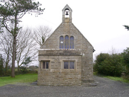 Saint Kevin's Church (Drumcliff)Church/chapel · 1.1 mi
Explorer Tom Saint Kevin’s Church in Drumcliff is tiny but packed with Tudor revival charm, including a corner window that looks like it’s peeking at you shamefully. It’s secretly proud of its potato-shaped buttress, even if nobody else has noticed yet. Stand back and admire the craftsmanship; don’t touch anything or the ghosts will get cross.
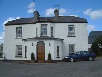 Urlar HouseHouse · 1.1 mi
Explorer Tom Urlar House has had so many names it’s started calling itself whatever it feels like that week, which is very annoying for the locals. The wrought-iron gate is splendid, but the house is more interested in its own identity crisis than your opinion. Ask if it wants to be called Bob today; maybe.
.jpg/250px-Front_view_of_Benbulbin_(2013).jpg "Photo: IrishFireside, Wikimedia Commons · CC BY-SA 2.0") BenbulbinMountain / peak · 1.5 mi
BenbulbinMountain / peak · 1.5 miExplorer Tom I came to Sligo expecting poetry; the mountain brought a geology lesson. Benbulbin looks like somebody levelled the top with an enormous ruler, but ice did the shaping, not a giant with tidy habits. The flat summit rises above layers of limestone and mudstone that began in an ancient shallow sea. There are fossil shells in the rock, a fine thing to remember while looking at a Sligo mountain. Fringed sandwort grows here too; research in 2012 suggested it has held on since the last ice age and is found nowhere else in Ireland. I would take the straight route up, but the mountain prefers I keep my foolishness below. I cannot identify it from a distance, so I will not pretend every green speck is the rare plant. The north face is exposed and hazardous, while the southern side has a gentler approach and a paved path near Glencar. Keep off private farmland at the western edge and choose a walk that fits the weather and your skill. Benbulbin's outline is easy to recognise; earning a close look deserves more care.
 BenbulbenMountain · 1.9 mi
Explorer Tom Benbulben would handle a nosey neighbour by just standing there silently, letting the sheer size of it do all the talking without lifting a finger. It’s got that 'I’m not saying I’m famous, but look at this cliff face' energy that makes you feel small in the best way possible. It's free, it's odd, what more do you want?
 Court tomb in GortnaleckCourt tomb · 2.0 mi
Explorer Tom Court tomb in Gortnaleck would win the county fair for best display of ancient stone architecture without even trying. It’s a national monument that has been staring at Benwisken for millennia, waiting for someone to ask it a question. Make a wish, it's had centuries of practice.
 Kings MountainMountain / peak · 2.5 mi
Explorer Tom Kings Mountain in County Sligo was saved by a hero so obscure even his own ghost forgets his name. It stands tall over the bog, pretending it didn't just fall asleep on the job. Pop by and tell it it's looking well.
 Drumcliff Round TowerVisitor attraction · 2.5 mi
Explorer Tom The Drumcliff Round Tower sings its favourite song to the wind, which is basically just the sound of a thousand years of echoing echoes. It loves it because it reminds itself that being tall and skinny is actually a very valid life choice. Bring wellies and low expectations, leave delighted.
 Stone crossCross, High cross · 2.5 mi
Explorer Tom Stone cross in Drumcliff South is tucked into the graveyard wall, eavesdropping on every funeral and gossiping about the deceased with the other stones. It hears everything through its carved walls. Bring a flask of something warm and a story to swap.
 Drumcliff CemeteryGraveyard · 2.5 mi
Explorer Tom Drumcliff Cemetery is incredibly proud that it sits in the shadow of Ben Bulben and looks better than your holiday photos. It’s right next to a river mouth, so the wind never stops talking. Take a breath of that air, it's older than your car.
 Rosses Point BeachBeach / strand · 4.0 mi
Explorer Tom The local sheep at Rosses Point seem to think I'm here to steal their opinions on the weather, which are surprisingly nuanced. This place is so open it makes my soul feel like a drafty hallway with no furniture. Ideal spot for a dramatic phone call.
 Waiting on ShoreMemorial · 4.4 mi
Explorer Tom The Waiting on Shore memorial is stuck in eternal suspense, looking at the sea like it’s expecting a delivery that’s been late for centuries. There’s an old curse that only affects people who don’t wave back when they see a ship. Great spot to propose. Or at least to propose lunch.
 Oyster IslandIslet · 4.6 mi
Explorer Tom Oyster Island was clearly designed by a mother-in-law who wanted to be close to you but not too close, with that lighthouse watching over everything like a suspicious auntie. It’s got a vibe of 'I know what you're up to,' which is honestly the best personality trait for an island. Bring a pen pal, they'll be jealous.
More archaeology and monuments in County Sligo · All of County Sligo

What do you know about this place?Tap to add a comment or ask a question