
What is recorded here
From the National Monuments Service (Archaeological Survey of Ireland) record WI027-053
Places near here
Photo credits
- Maker not stated on source page, www.flickr.com
- Maker not stated on source page, www.pinterest.com
- Maker not stated on source page, en.wikipedia.org
- Trevor Littlewood, Wikimedia Commons · CC BY-SA 2.0
- National Inventory of Architectural Heritage
- Sarah777, Wikimedia Commons · Public domain
 Fairy fort / earthen ringfort in Colvinstown LowerFairy fort / earthen ringfort · 194 yd
Explorer Tom Fairy fort in Colvinstown Lower would tell you its biggest secret after three pints, but right now it’s just lying…
Enclosure in KelshaEnclosure · 462 ydExplorer Tom Enclosure in Kelsha has a bad poem written about it somewhere that rhymes 'bank' with 'thank', and frankly, I don't…
 Ogham stone in BoleycarrigeenOgham stone · 886 yd
Explorer Tom Ogham stone in Boleycarrigeen would bring its own chisel to any party and start carving names into walls. It’s just a…
 Fairy fort / stone ringfort in KelshabegFairy fort / stone ringfort · 1231 yd
Explorer Tom Fairy fort / stone ringfort in Kelshabeg has very strong opinions on modern buildings and thinks they’re all just…
 Anomalous stone group in Colvinstown UpperAnomalous stone group · 1325 yd
Explorer Tom Anomalous stone group in Colvinstown Upper is basically twenty big white quartz boulders having a very serious meeting…
 Kilranelagh Church in ruinsChurch · 1453 yd
Explorer Tom Kilranelagh Church in Colvinstown Upper is playing hide-and-seek with me. A tale from 1846 says an earl built it, but…
 Kilranelagh GraveyardGraveyard · 1477 yd
Explorer Tom Kilranelagh Graveyard would order the biggest portion of chips they could possibly get, extra thick, with gravy that is…
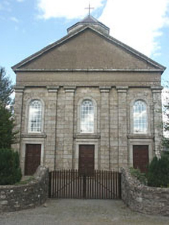 Saint Brigid's Catholic ChurchChurch/chapel · 1.1 mi
Explorer Tom Saint Brigid's Catholic Church in Talbotstown Upper is throwing a Classical party when everyone else in town is doing…
 Humewood CastleGate lodge · 1.1 mi
Explorer Tom Humewood Castle is a gate lodge that thinks it’s the main event. It gets tired of people asking why a 'castle' is…
Ogham stone in UnknownOgham stone · 1.1 miExplorer Tom Ogham stone in County Wicklow is sick of being asked if it’s broken, because yeah, people actually used it for wall…
Enclosure in KeadeenEnclosure · 1.2 miExplorer Tom Enclosure in Keadeen has a long grudge against the weather because the wind keeps blowing its stones into a heap every…
 Keadeen MountainMountain / peak · 1.7 mi
Explorer Tom Keadeen Mountain stands apart at the south-west edge of the Wicklow Mountains, looking across the Glen of Imaal toward…
More archaeology and monuments in County Wicklow · All of County Wicklow

What do you know about this place?Tap to add a comment or ask a question