
Places near here
Photo credits
- John Lucas, Geograph · Creative Commons Attribution-ShareAlike 2.0
- National Inventory of Architectural Heritage
- David Purchase, Geograph · Creative Commons Attribution-ShareAlike 2.0
- Duncan Grant, Wikimedia Commons · CC BY-SA 2.0
- Mike Searle, Geograph · CC BY-SA 2.0
- Paul Cowan, Wikimedia Commons · CC BY-SA 2.0
 Saint Joseph's Catholic ChurchChurch/chapel · 625 yd
Explorer Tom Saint Joseph's Catholic Church in Tomboholla made a New Year’s resolution to stop judging the villagers. It failed spectacularly because the windows are still staring at you like they know your sins. Bring your worst joke, the place won't mind.
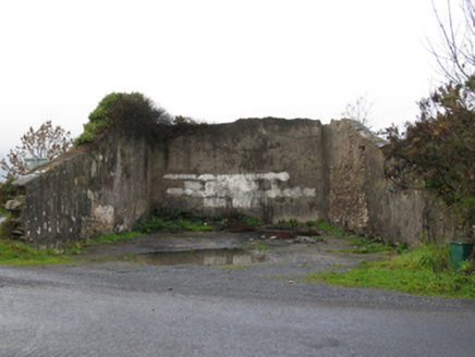 handball alley1180 yd
Explorer Tom This handball alley in Tomboholla has a local superstition: if you miss three shots, your socks will shrink overnight. It's dilapidated but still haunts the dreams of every bad player who ever touched its walls. Have a chat with it, nobody else will listen anyway.
Brabazon WoodsForest · 4.7 miExplorer Tom Brabazon Woods would tell you in a job interview that its main skill is standing still for centuries without complaining at all. It sits next to a historic estate, so it’s used to being looked down on by people with better hats. Visit, then text me what you think. I'll pretend to read it.
Procession Of The SoulsMemorial · 4.8 miExplorer Tom Procession Of The Souls is a memorial where the dead are definitely walking in a line, which is very organised for people who aren't alive. I bet there’s a hidden treasure down there that turns out to be nothing more than a rusty biscuit tin. It’s got a spooky name but a very bureaucratic feel to it. Bring a map, get lost anyway, that's the fun.
East Mayo Brigade MonumentMemorial · 4.9 miExplorer Tom East Mayo Brigade Monument stands there looking serious, probably because two lads in the pub once made a bet about who could build the flashiest stone. They lost their shirts over it, but hey, we got a monument that looks like it’s judging your haircut every time you pass by. It’s got that 'don't touch me' energy, which is fair enough. Pretend it's yours and plan the housewarming.
Thorn CaveCave · 6.5 miExplorer Tom Thorn Cave in Mayo is basically a goatee for geology, just all prickly and weird. A goat once ruled this spot with an iron hoof and demanded tribute in the form of clover. This is your ideal stop for a massive stretch and a yawn that could wake the dead.
 Grave YardGraveyard · 6.8 mi
Explorer Tom Graveyard in Aghamore would post a photo of its mossy headstones with the caption 'Living my best quiet life, #ancient'. It’s got that moody, atmospheric vibe going on that makes you feel instantly profound. Have a wander and a wonder.
 CashelFairy fort / stone ringfort · 6.9 mi
Explorer Tom Another cashel in Kilcashel stands tall on the ridge, looking down its nose at everyone else with its thick, sturdy drystone walls. The builder was definitely thinking about views when they stacked those rocks, ignoring the wind and the cold completely. Bring biscuits, every good story needs biscuits.
Old Cave Burial GroundArchaeological place · 7.1 miExplorer Tom Old Cave Burial Ground is where Saint Patrick probably stopped to complain about the humidity before moving on to the next hill. It’s an archaeological spot that feels like it’s hiding something under all that moss and mystery. The dead are definitely having a better time than we are up here in the sun. Go in good boots and better humour.
 CastleCastle, unclassified · 9.9 mi
Explorer Tom Castle on Island Lake hates when people ask if it’s haunted; it prefers ‘mysteriously absent’. It vanished so fast the locals just shrugged and built a house instead. Bring a flask of something warm and a story to swap.
 IndicatedHouse, fortified house · 10.0 mi
Explorer Tom House in Island is currently being judged by rabbits who think its gunloops are just fancy holes for them to hide in. They’re not wrong, actually. Get there early and have it all to yourself.
 Knock ShrineHeritage attraction · 10 mi
Explorer Tom I'll keep my big mouth quiet for the people praying at Knock. Knock Shrine grew from an evening that the people present never forgot. On 21 August 1879, Mary Byrne and other villagers said they saw figures at the church gable while the Mayo rain came down. Their accounts describe a still scene that lasted nearly two hours, with people gathering and praying; the witnesses also said the ground around the figures stayed dry. I am not going to tell you what they saw. Mayo rain rarely asks my permission, but the witnesses' account asks for careful listening. What I can tell you is that their words were taken down by a church inquiry that autumn, and a second inquiry in 1936 returned to surviving witnesses because many early papers were thought lost. The original wall attracted so many visitors that pieces were taken away as souvenirs. Today this is a living place of pilgrimage, so enter with care for the people who have come to pray. Whatever you believe, listen to how a wet evening changed a village's place in the world.
More archaeology and monuments in County Mayo · All of County Mayo

What do you know about this place?Tap to add a comment or ask a question