What is recorded here
From the National Monuments Service (Archaeological Survey of Ireland) record WI007-005
Places near here
Photo credits
- Britishfinance, Wikimedia Commons · CC BY-SA 4.0
- JP, Geograph · Creative Commons Attribution-ShareAlike 2.0
- Miguel Angel Masegosa Martínez, Wikimedia Commons · CC BY 2.0
- Sheila1988, Wikimedia Commons · CC0
- Vicente Fernández Rioja, Wikimedia Commons · CC BY-SA 4.0
- JP, Geograph · CC BY-SA 2.0
- Rob Hurson, Wikimedia Commons · CC BY-SA 2.0
- Joe King, Wikimedia Commons · CC BY-SA 3.0
- jwd, Geograph · CC BY-SA 2.0
- Draceane, Wikimedia Commons · CC BY-SA 3.0
- Barry, Geograph · CC BY-SA 2.0
 Prince William's SeatMountain / peak · 1176 yd
 Saint Patrick's Catholic ChurchChurch/chapel · 1598 yd
 Glencullen BridgeBridge · 1.6 mi
Explorer Tom Glencullen Bridge in County Dublin has ivy growing on its three arches! Extant since 1837, it’s proper weathered now. Take a picture of those lichen-spotted voussoirs for me!
 Sweet Chestnut1.7 mi
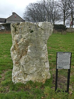 Glencullen Standing StoneArchaeological place · 2.0 mi
Explorer Tom Glencullen Standing Stone in County Dublin has been standing there since before my great-grandmother was born. It’s got patience, I respect that, even if it’s boring.
 Monkey-puzzle2.1 mi
 Glencree German War CemeteryHeritage attraction · 2.4 mi
 TonduffMountain / peak · 2.5 mi
 Ballyedmonduff Wedge TombArchaeological place · 2.6 mi
Explorer Tom Ballyedmonduff Wedge Tomb is locally known as the 'Giant's Grave', which sounds way cooler than wedge tomb. It was excavated in the forties and found to be full of fancy pots and flint.
 Source of River LiffeySpring · 3.3 mi
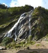 Powerscourt WaterfallWaterfall · 3.4 mi
 Wicklow WayWalking route · 3.4 mi
Explorer Tom Wicklow Way in County Dublin is walking towards a Fairy Fort. That’s either great or terrifying, depending on your luck. Take a picture of the fort before it moves away!
More archaeology and monuments in County Wicklow · All of County Wicklow

What do you know about this place?Tap to add a comment or ask a question