
What is recorded here
In pasture, on a hillock overlooking a small stream. A long earthen mound (c. 56m E-W; 10m N-S; H c. 1.4m) incorporating part of a natural rise. The W end of the mound slopes down to W, is wedge-shaped (18m E-W; 8m N-S at E end; 7m N-S at W end) and revetted with large boulders. A large limestone slab (L 2.6m; Wth…
Read the whole record
From the National Monuments Service (Archaeological Survey of Ireland) record SL021-026002
Places near here
Picture notes
- Computer-made picture. It does not show this monument.
- Computer-made picture. It does not show this playground.
- National Inventory of Architectural Heritage
- Mike Searle, Wikimedia Commons · CC BY-SA 2.0
- Computer-made picture. It does not show this mountain top.
- Oliver Dixon, Geograph · CC BY-SA 2.0
- Lucarelli, Wikimedia Commons · CC BY-SA 3.0
- Bob Embleton, Wikimedia Commons · CC BY-SA 2.0
 Anomalous stone group in CastleoreAnomalous stone group · 15 ydTom: I’m here to help · Computer-made picture. It does not show this monument.
Explorer Tom Anomalous stone group in Castleore has caught my eye in Castleore, County Sligo. I bet a anomalous stone group with a name like that could keep me talking all afternoon; I'm already inventing a daft little scene for it, and I'll stop before it turns into history.
 Man-made underground passage in CastleoreMan-made underground passage · 197 ydTom: I’m here to help · Computer-made picture. It does not show this monument.
Explorer Tom Man-made underground passage in Castleore has caught my eye in Castleore, County Sligo. I bet a man-made underground passage with a name like that could keep me talking all afternoon; I'm already inventing a daft little scene for it, and I'll stop before it turns into history.
 Children's playground1518 ydTom: I’m here to help · Computer-made picture. It does not show this playground.
Explorer Tom Children's playground has caught my eye in County Sligo. I bet a children's playground with a name like that could keep me talking all afternoon; I'm already inventing a daft little scene for it, and I'll stop before it turns into history.
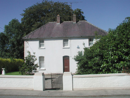 The PresbyteryPresbytery/parochial/curate's house · 1538 yd
Explorer Tom The Presbytery has caught my eye in Tiratick, County Sligo. I bet a presbytery/parochial/curate's house with a name like that could keep me talking all afternoon; I'm already inventing a daft little scene for it, and I'll stop before it turns into history.
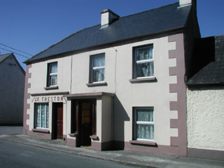 J.f. TrestonHouse · 1575 yd
Explorer Tom J.f. Treston has caught my eye in Tiratick, County Sligo. I bet a house with a name like that could keep me talking all afternoon; I'm already inventing a daft little scene for it, and I'll stop before it turns into history.
 Drumcondra Castle (in Ruins)Castle, tower house · 1614 yd
Explorer Tom Drumcondra Castle has caught my eye in Drumcondra, County Sligo. I bet a castle, tower house with a name like that could keep me talking all afternoon; I'm already inventing a daft little scene for it, and I'll stop before it turns into history.
 Killerry MountainMountain / peak · 1.6 miTom: I’m here to help · Computer-made picture. It does not show this mountain top.
Explorer Tom Killerry Mountain has caught my eye in County Sligo. I bet a mountain / peak with a name like that could keep me talking all afternoon; I'm already inventing a daft little scene for it, and I'll stop before it turns into history.
 Slishwood Island EastIslet · 2.2 mi
Explorer Tom Slishwood Island East has caught my eye in County Sligo. I bet a islet with a name like that could keep me talking all afternoon; I'm already inventing a daft little scene for it, and I'll stop before it turns into history.
 Slieve DaeaneMountain / peak · 2.5 miTom: I’m here to help · Computer-made picture. It does not show this mountain top.
Explorer Tom Slieve Daeane has caught my eye in County Sligo. I bet a mountain / peak with a name like that could keep me talking all afternoon; I'm already inventing a daft little scene for it, and I'll stop before it turns into history.
 Cottage IslandIslet · 2.9 mi
Explorer Tom Cottage Island has caught my eye in County Sligo. I bet a islet with a name like that could keep me talking all afternoon; I'm already inventing a daft little scene for it, and I'll stop before it turns into history.
 Holm Oak3.5 mi
Explorer Tom Holm Oak has caught my eye in County Sligo. I bet a holm oak with a name like that could keep me talking all afternoon; I'm already inventing a daft little scene for it, and I'll stop before it turns into history.
 Tobernalt Holy WellSpring · 3.5 mi
Explorer Tom Tobernalt Holy Well has caught my eye in County Sligo. I bet a spring with a name like that could keep me talking all afternoon; I'm already inventing a daft little scene for it, and I'll stop before it turns into history.
More archaeology and monuments in County Sligo · All of County Sligo

What do you know about this place?Tap to add a comment or ask a question