Places near here
Photo credits
- National Inventory of Architectural Heritage
- Mike Searle, Geograph · Creative Commons Attribution-ShareAlike 2.0
- Mike Searle, Geograph · CC BY-SA 2.0
- Mike Searle, Wikimedia Commons · CC BY-SA 2.0
- Unknown author Unknown author, Wikimedia Commons · Public domain
- CaitNi, Wikimedia Commons · CC BY-SA 4.0
Explorer Tom Moated site in Ballynadrideen got flattened in the sixties, so it’s basically invisible now. The maps say it was square, but the ground says 'meh'. Good luck finding a ghost of a wall out there, mate!
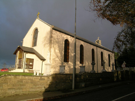 Saint Mary's Roman Catholic ChurchChurch/chapel · 1297 yd
Explorer Tom Saint Mary's Roman Catholic Church in Ballycoskery looks plain on the outside since 1831, but inside it’s all gilded columns and fancy paintings that will knock your socks off. It’s one of those places where the exterior is a modest promise of a very ornate interior surprise.
 presbytery/parochial/curate's house1297 yd
Explorer Tom The presbytery in Ballycoskery is showing off its cross-shaped plan from 1905. It’s got a nice classical rhythm and was designed by a Sheehy guy. It looks like the vicar knows exactly where he stands.
Holy Cross CemeteryGraveyard · 2.2 miExplorer Tom Holy Cross Cemetery is triangular, which makes it look like it’s trying to sneak away from the square ones. It’s got an older section inside it that’s basically a grandfather in a trench coat. Bring a map, get lost anyway, and try not to trip over your own feet.
CarrigeenMountain / peak · 2.4 miExplorer Tom Carrigeen has strict rules for visitors that are never written down but somehow everyone feels guilty if they break them. You have to whisper when you approach, otherwise it thinks you’re being rude to the moss. It’s probably judging your hiking boots right now from the top of its rocky head. Get there early and have it all to yourself.
BallinaboolaVisitor information · 2.5 miExplorer Tom Ballinaboola in County Cork has forest trails where a fiddler once played all night until his fingers turned to stone. The trees are still listening for the melody, so keep your voice down or they’ll get jealous. Have a sandwich here and call it a heritage lunch, you’re welcome.
Ballyhoura WayWalking route · 3.4 miExplorer Tom The Ballyhoura Way in County Cork has very strong opinions about modern buildings, specifically that they should all be made of stone and shaped like a hill. It looks down on concrete with the disdain of a true aristocrat who has seen better days. If it's closed, admire it from the road like a polite stalker.
 Grave YardGraveyard · 4.1 mi
Explorer Tom Graveyard in Churchtown is hosting a very exclusive party for the dead. Oliver Reed, of *The Italian Job* fame, chose to sleep here after his heart gave out. It’s got an 18th-century vibe and a ruined church in the middle. Knock on the iron gate politely if you’re feeling brave!
 Templeconnell Castle (in Ruins)Castle, tower house · 4.7 mi
Explorer Tom Templeconnell Castle is a five-storey tower that looks like it went to war with gravity and lost slightly. The Percivals took over in 1656 after the Magners got tired of the drama. A good place to forget your phone for ten minutes and feel ancient.
.jpg/250px-Castles_of_Munster-_Kilcolman,_Cork_(geograph_3036773).jpg "Photo: Mike Searle, Wikimedia Commons · CC BY-SA 2.0") Kilcolman CastleCastle · 5.2 mi
Kilcolman CastleCastle · 5.2 miExplorer Tom Kilcolman Castle gave Edmund Spenser a tower, thousands of acres and scenery for The Faerie Queene, yet the building refused to stay whole. James FitzGerald first built the Cork tower in the 1420s. Spenser received it with about 3,028 acres in the 1580s and lived there for a decade while writing. It was destroyed in 1598, rebuilt by his son and lost again in 1622. I would claim my own verse could have kept the roof on, but the history is unkind to that boast. The ruin stands near Kilcolman Bog, an old landscape worth seeing in its own right. Check lawful access and view from safe ground; do not enter unsafe remains or cross private land for a literary photograph. The castle's walls failed twice, but its place in a book travelled much farther.
 Battle of LiscarrollMajor battlefield · 6.9 mi
Explorer Tom Battle of Liscarroll in County Cork is where two armies had a massive row in 1642, and honestly, I think they just wanted different chips at the chippy. Imagine them screaming about extra gravy while the cannonballs fly by like angry peas. Have a look and decide if I was lying.
 CarrigeenamronetyMountain / peak · 10.0 mi
Explorer Tom Carrigeenamronety in County Limerick is like the quiet cousin at the wedding who stands in the corner eating canapés and judging everyone’s outfit choices without saying a single word. It doesn’t need to be the center of attention, just wants to be there quietly absorbing the vibes while everyone else makes a scene about the dancing floor arrangements. Have a l
More archaeology and monuments in County Cork · All of County Cork

What do you know about this place?Tap to add a comment or ask a question