
Places near here
Photo credits
- National Inventory of Architectural Heritage
- Kenneth Allen, Wikimedia Commons · CC BY-SA 2.0
- Kay Atherton, Geograph · CC BY-SA 2.0
- Newbert12, Wikimedia Commons · CC BY-SA 4.0
- Neville Goodman, Geograph · Creative Commons Attribution-ShareAlike 2.0
- Liz McCabe, Geograph · CC BY-SA 2.0
- Ray Martin, Wikimedia Commons · Public domain
- Mike Searle, Wikimedia Commons · CC BY-SA 2.0
- Pamela Norrington, Geograph · CC BY-SA 2.0
- Alan Reid, Geograph · CC BY-SA 2.0
- Richard Webb, Geograph · CC BY-SA 2.0
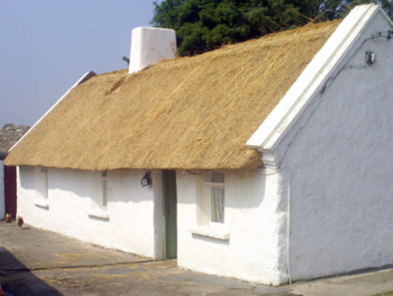 farm house1.2 mi
Explorer Tom Farm house in Ballycong has a bird that refuses to leave. It sits on the roof like it owns the place. The thatch is old-school and the stone is rough. Go with someone who loves silence, or bring your own noise machine.
 bridge1.9 mi
Explorer Tom Bridge in Stonehall has an escape plan involving a very narrow gap and a lot of pretending it’s not scared. The first owner probably ran off with his hat when the rain started. Ideal stop for a big sigh of relief.
 Admiral William BrownMemorial · 3.4 mi
Explorer Tom Admiral William Brown has an imaginary fan club that meets every Tuesday, mostly just to complain about the wind and the lack of decent biscuits nearby. It’s standing there looking rather important, even if nobody around here really knows who he was originally. A handy spot to stretch your legs and your imagination a bit.
 Lough CullinViewpoint · 3.5 mi
Explorer Tom Lough Cullin again? Apparently there are two of them, which is either impressive or lazy. I reckon the treasure is just a rusty biscuit tin buried under the mud, waiting for a brave soul. The Nephins in the distance are judging us, but we don’t care. Mind the nettles, they're the real guards here.
 IndicatedWedge tomb · 5.1 mi
Explorer Tom Wedge tomb in Carrowcrom is named after lovers but looks more like a bed where nobody wants to sleep. It’s got a name that sounds romantic but feels a bit dusty and lonely. Go before the tourists find out.
 Graveyard6.9 mi
Explorer Tom Graveyard in Knockmaria or Addergoole has an ivy-covered church that looks like it ate a hedge and felt guilty about it. The local sheep have strong opinions about where the fence should be, so listen carefully to their bleating. It is marked on maps as ancient but feels very much like a nap spot. Tell the kids it's a castle. Close enough.
 FarbreigaMountain / peak · 7.3 mi
Explorer Tom Farbreiga is hiding a secret message in its stones that only very tired hikers can decipher after a long walk. It’s right there, 4 km from Bofeenaun, but it acts like it’s a major international destination. Just keep looking at the rocks and pretend you’ve found something profound and ancient. Go at sunset and thank me later.
 CastleCastle, tower house · 7.6 mi
Explorer Tom Castle in Deelcastle hosted a dance that went so far nobody remembers who started it. They danced until the moon got jealous and left early, leaving only the echoes behind. A proper spot for a flask of tea and a big think, mate.
 Deel CastleCastle · 7.7 mi
Explorer Tom Deel Castle claims it smuggled moonshine in barrels back in the day, but I suspect it just hid its own bad breath. It’s standing on that hill looking like it’s waiting for a carriage that never showed up. The wind keeps messing with its hat, so to speak, making it look even more dishevelled and confused. Ideal place to rehearse an excuse for being late.
 Titanic Memorial ParkMemorial · 8.2 mi
Explorer Tom Titanic Memorial Park: Imagine the Titanic ordering chips here; I reckon it would go for the extra thick, salted ones with a side of regret. Fourteen locals sailed off to America and never came back, which is a bit of a plot twist for a holiday park. It’s a quiet corner that reminds you how deep the sea really is. It's the kind of place that makes a dull Tuesday interesting.
 Largan HillMountain / peak · 9.2 mi
Explorer Tom Largan Hill in County Sligo is strictly run by a terrier who barks at any cloud that passes overhead. The forest below looks young and confused, probably from all the shouting. Perfect detour when the satnav has a meltdown.
 Lough Talt TrailVisitor information · 9.5 mi
Explorer Tom Lough Talt Trail has a shortcut that is technically longer if you count the time spent arguing about which way is down. The water supply up there is public, but the ego of this trail seems to be private property. Get there early and have it all to yourself.
More archaeology and monuments in County Mayo · All of County Mayo

What do you know about this place?Tap to add a comment or ask a question