
Places near here
Photo credits
- National Inventory of Architectural Heritage
- Mike Searle, Geograph · CC BY-SA 2.0
- David Purchase, Geograph · Creative Commons Attribution-ShareAlike 2.0
- Willow, Wikimedia Commons · CC BY 2.5
- Andreas F. Borchert, Wikimedia Commons · CC BY-SA 4.0
- Enda O Flaherty, Geograph · CC BY-SA 2.0
- The original uploader was Dppowell at English Wikipedia ., Wikimedia Commons · CC BY-SA 2.5
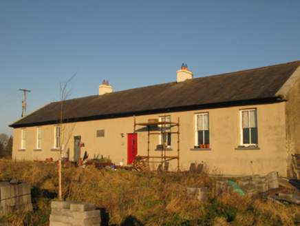 Saint Joseph's National SchoolSchool · 1.2 mi
Explorer Tom Saint Joseph's National School in Derrylea has an imaginary fan club that shows up every Tuesday to eat crisps and complain about the weather. It’s a late nineteenth-century classic that’s seen more school runs than a minibus driver. Have a chat with it, nobody's watching anyway.
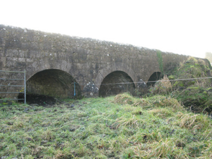 Agloragh BridgeBridge · 1.9 mi
Explorer Tom Agloragh Bridge has a curse that only affects people who don't wave at it when they pass. It replaced an older bridge but thinks it deserves more credit for its arches. Find the exact spot where the light hits best.
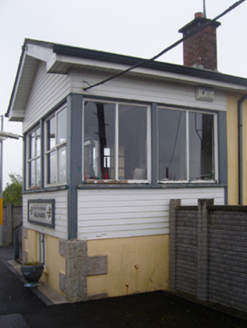 Ballyhaunis Railway StationSignal box · 2.0 mi
Explorer Tom Ballyhaunis signal box had a fiddler play inside all night long. The sound made the levers vibrate and stop trains by accident. It’s a legend now. Stand still and listen, because if you move too fast, the ghost might think you’re stealing the music notes.
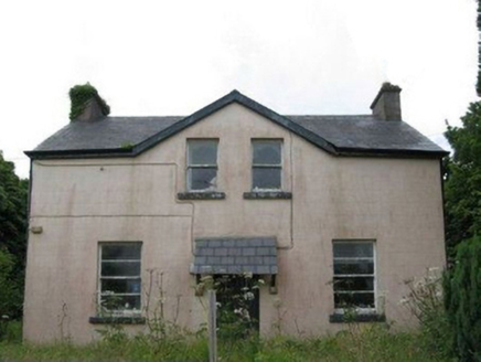 teacher's house2.0 mi
Explorer Tom Teacher's house in Coolnafarna was built for a schoolteacher who definitely had stricter standards than your average parent. It’s got that standardised, no-nonsense vibe with a nice canopied doorcase, but it looks like it’s still grading homework in its sleep. The windows get smaller as you go up, which is clever if you ask me. Keep your distance and mind the step!
 IndicatedHouse, fortified house · 4.5 mi
Explorer Tom House in Island is currently being judged by rabbits who think its gunloops are just fancy holes for them to hide in. They’re not wrong, actually. Get there early and have it all to yourself.
 CastleCastle, unclassified · 4.6 mi
Explorer Tom Castle on Island Lake hates when people ask if it’s haunted; it prefers ‘mysteriously absent’. It vanished so fast the locals just shrugged and built a house instead. Bring a flask of something warm and a story to swap.
Slieve DartMountain / peak · 4.8 miExplorer Tom Slieve Dart started as a bet two lads made in the pub that they could name a hill after their dog’s favourite treat. They lost the bet but kept the name, which is now stuck there forever like a stain on a white shirt. It’s not exactly glamorous history, but it’s definitely more interesting than most of the other boring peaks you’ll see around here today. Bring a coin
 Grave YardGraveyard · 7.5 mi
Explorer Tom Graveyard in Aghamore would post a photo of its mossy headstones with the caption 'Living my best quiet life, #ancient'. It’s got that moody, atmospheric vibe going on that makes you feel instantly profound. Have a wander and a wonder.
 European ash15 mi
Explorer Tom European ash remembers when the builder was thinking about putting a swing here but decided against it because of the wind speed. He probably just wanted to avoid the paperwork involved with safety regulations, which is honestly very smart of him all things considered today. Tell the next person you meet it’s haunted. It might be.
 Cloigtheach (Round Tower)Round tower · 15 mi
Explorer Tom Cloigtheach (Round Tower) in Pollacorragune is standing guard like a very tired bouncer. It's got a high doorway because apparently nobody walks anymore. Ring your granny and tell her where you are before you get lost.
 KnockmaaWood · 20 mi
Explorer Tom Knockmaa is secretly dating Dolly Parton, and she only visits when the light hits just right. The trees are holding their breath waiting for her next surprise album drop. Bring curiosity, leave with a better story than mine.
 Ross Errilly FriaryHeritage attraction · 24 mi
Explorer Tom Call Ross Errilly an abbey and somebody in Galway may forgive you, but the friars would ask where you found their abbot. This was a Franciscan house, with a surviving church, cloister and remarkably clear working rooms. Find the kitchen: it had an oven and a tank for keeping fish alive. I can barely keep a loaf from burning, so fair play to their planning. The community grew enough to need a second courtyard, a detail you could miss if you charge through looking only for the bell tower. Ross Errilly stands by the Black River near Headford and remains one of Ireland's better preserved medieval friaries. Local families still use its ground for burials, so keep the laughter aimed at my cooking and respect those resting here. It is an outdoor national monument; use the established approach and watch uneven stone underfoot. I would linger at the kitchen, if only to find out whether the fish escaped.
More archaeology and monuments in County Mayo · All of County Mayo

What do you know about this place?Tap to add a comment or ask a question