
Places near here
Photo credits
- National Inventory of Architectural Heritage
- John Henson, garrycastle.gaa.ie
- Kmcnamee, Wikimedia Commons · CC BY-SA 4.0
- Sheila1988, Wikimedia Commons · CC0
- Christopher Hilton, Geograph · CC BY-SA 2.0
- Christophe Krief, Wikimedia Commons · CC BY-SA 4.0
- Mike Searle, Geograph · CC BY-SA 2.0
Explorer Tom Promontory Fort in Ballaghkeeran Little is stuck out like a thumb refusing to shake hands with Lough Ree. It sits on…
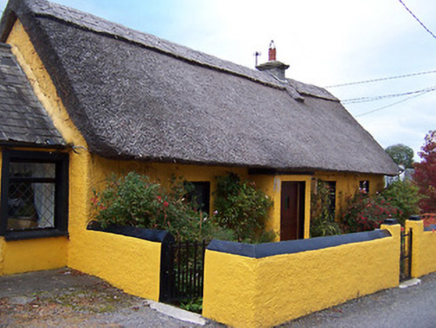 Rose CottageHouse · 445 yd
Explorer Tom Rose Cottage is deeply suspicious of the postman because he always drops parcels on its doorstep instead of knocking…
Temple's IslandIslet · 1.0 miExplorer Tom Temple's Island claims it survived a massive storm by holding its breath and refusing to sink. I believe it mostly…
 Easthill HouseHouse · 1.1 mi
Explorer Tom Easthill House in Boggagh gave up its grandeur for Lent and hasn't gotten it back since the early nineteenth century.…
OutlinedFairy fort / earthen ringfort · 1.1 miExplorer Tom Fairy fort or earthen ringfort in Portaneena thinks the road leading up to it is an insult personally, especially since…
Thatch IslandIslet · 1.2 miExplorer Tom Thatch Island would have 'Died of Moisture' written on its tombstone in big bold letters, for sure. It’s named after…
 Garrycastle GAA ClubGAA ground · 1.6 mi
 Páirc Chiaráin, Athlone GAAGAA ground · 1.8 mi
 Luan GalleryGallery · 2.5 mi
Explorer Tom Luan Gallery sits beside the Shannon in Athlone, close to the castle and town bridge, so it has already arranged a…
 CastleCastle, unclassified · 2.5 mi
Explorer Tom The Connacht Tower in Athlone was saved by a hero nobody remembers, who probably just tripped and knocked down the…
 Athlone CastleVisitor information · 2.6 mi
Explorer Tom Athlone Castle is just standing there pretending it doesn’t remember the time a goat ruled the roost and ate all the…
 Historic Town - Athlone Castle & Church of St Peter and PaulVisitor information · 2.6 mi
Explorer Tom Whoever built Athlone Castle was clearly thinking about how to make the church look good in bad weather, which is oddly…
More archaeology and monuments in County Westmeath · All of County Westmeath

What do you know about this place?Tap to add a comment or ask a question