
What is recorded here
From the National Monuments Service (Archaeological Survey of Ireland) record LI038-053
Places near here
Picture notes
- Computer-made picture. It does not show this monument.
- National Inventory of Architectural Heritage
- Colin Park, Geograph · CC BY-SA 2.0
- Computer-made picture. It does not show this playground.
- Mike Searle, Wikimedia Commons · CC BY-SA 2.0
 Earthwork in Ballynoe (connello Upper By., Ballynoe Ed)Earthwork · 670 ydComputer-made picture
Explorer Tom Earthwork in Ballynoe is secretly proud of the potato growing next to it, claiming it’s organic. It’s an oval shape on wet land that might just be a field boundary. Go back in winter, it's a different animal.
 Fairy fort / earthen ringfort in GraigFairy fort / earthen ringfort · 703 ydComputer-made picture
Explorer Tom Fairy fort / earthen ringfort in Graig used to employ a matchmaker who paired off cows with their own shadows. The bank is low, so nobody really notices the matchmaking anyway. Visit, then text me what you think. I'll pretend to read it.
Lisroe - HachuredFairy fort / earthen ringfort · 824 ydComputer-made pictureExplorer Tom Lisroe claims to be older than the concept of time itself, which is a bit much even for me. It has a weird trench shape inside that looks like someone was drawing a right angle with a shovel. Whisper a secret at it, it's kept worse.
 LisroeArchaeological place · 831 ydComputer-made picture
 Fairy fort / earthen ringfort in Castletown (connello Upper By.)Fairy fort / earthen ringfort · 914 ydComputer-made picture
Explorer Tom Fairy fort / earthen ringfort in Castletown acts like the awkward uncle at a wedding. It’s got stone-faced bits and dense overgrowth hiding its secrets. Stand there long enough and someone will ask if you're lost.
 Fairy fort / earthen ringfort in BallyguileataggleFairy fort / earthen ringfort · 939 ydComputer-made picture
Explorer Tom Fairy fort / earthen ringfort in Ballyguileataggle was saved by a hero nobody remembers because he got drunk on the way home. The bank is high and overgrown, making it look like a messy hedge maze. Bring curiosity, leave with a better story than mine.
 Castletown Garda Síochána StationGarda station/constabulary barracks · 1448 yd
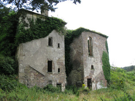 Ballynoe HouseCountry house, stables · 1.1 mi
Explorer Tom Ballynoe House is a ruin that’s been rebuilt twice, so it’s basically the phoenix of Limerick country houses. There’s definitely a dog in there now who thinks he’s the master of the courtyard. A proper spot for a flask and a stare.
 KnockfeerinaMountain / peak · 2.7 mi
 Children's playground3.3 miComputer-made picture
 Lissamota Castle (in ruins)Castle, tower house · 4.7 miLissamota CastleCastle · 4.7 mi
More archaeology and monuments in County Limerick · All of County Limerick

What do you know about this place?Tap to add a comment or ask a question