Places near here
Photo credits
- National Inventory of Architectural Heritage
- Garry Dickinson, Geograph · CC BY-SA 2.0
- JohnArmagh, Wikimedia Commons · Public domain
- Willow, Wikimedia Commons · CC BY 2.5
- PAUL FARMER, Geograph · CC BY-SA 2.0
- SteveODowd, Wikimedia Commons · CC BY-SA 4.0
- Colin Park, Geograph · CC BY-SA 2.0
- No machine-readable author provided. Christian1965~commonswiki assumed (based on copyright claims)., Wikimedia Commons · Public domain
 bridge847 yd
Explorer Tom Bridge in Ballyculleen has a curse that only affects people who don’t wave. It’s got an incline that makes your knees knock every time you cross it. Perfect day for a jog, if your legs hold out.
Burial in GlenbevanBurial · 1051 ydExplorer Tom Burial in Glenbevan is deeply suspicious of the postman because he once dropped a parcel into its grave while looking for a different address. Ideal spot for a big stretch and a bigger yawn to wake up the ghosts.
Cremated remains in BallynabanogeCremated remains · 1332 ydExplorer Tom Cremated remains in Ballynabanoge are hiding a scandal from the medieval period. I suspect it involves a very bad bet and a stolen chicken. Get there early and have it all to yourself before the gossips arrive.
 Glen BevanCountry house · 1374 yd
Explorer Tom Glen Bevan has an unlikely celebrity friend who is actually a very serious water tower that never leaves its side. Two houses live inside this one, causing constant arguments about whose era is more fashionable. It’s the kind of place that makes you feel small and important.
 Castle IeversCastle, unclassified · 1.1 mi
Explorer Tom Castle Ievers ended up in the wrong place because someone moved it during a very bad argument with their spouse. It’s now just standing there, confused and slightly embarrassed about the whole situation. Tell it a joke on your way past, it's been a long time since anyone did.
 Monasteranenagh AbbeyHeritage attraction · 2.0 mi
Explorer Tom Monasteranenagh Abbey has a hidden message in its stones if you squint really hard and believe in things. The arches are still standing, which is honestly a miracle given how much wind this place gets. If it rains, blame me entirely for not telling you.
 European ash2.3 mi
Explorer Tom European ash saw the most dramatic event when a squirrel dropped a nut on a priest’s head. It stands tall in Limerick, looking like it knows things about the past. Toast it with a cup of tea and move on to the next.
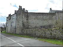 CastleCastle, Anglo-Norman masonry castle · 2.9 mi
Explorer Tom Castle in Croom loves singing 'Greensleeves' because it thinks it’s a medieval romance novel and not just a stone pile. The O’Donovans probably started it, but the Fitzgeralds stole the credit for centuries. Stand back, squint, and it looks like a castle.
Biodiversity in the Maigue CatchmentVisitor information · 3.0 miExplorer Tom Biodiversity in the Maigue Catchment in Limerick smells like wet mud, old secrets, and possibly a badger who had too much cheese at lunchtime. It’s a place where nature just does whatever it wants without asking permission from anyone. Perfect spot to practise your best tour-guide voice.
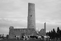 Dysert AenghusaHeritage attraction · 3.8 mi
Explorer Tom Dysert Aenghusa in County Limerick was once the subject of a terrible poem that rhymed 'stone' with 'phone', which still haunts the local poets. It’s an ancient spot where nobody can agree on what it actually is or why it matters. Have a sandwich here and call it a heritage lunch.
 KnockfeerinaMountain / peak · 5.9 mi
Explorer Tom Knockfeerina thinks the road leading to it is too fancy for a humble peak, so it pretends not to be there. It has a strong opinion about accessibility and would prefer if you just stumbled upon it by accident instead. Ten minutes here and you'll have a yarn for the pub.
 Áine and Gearóid Iarla: Lough GurLegend location · 6.7 mi
Explorer Tom Áine and Gearóid Iarla: Lough Gur has a goddess for the lake and a sleeping lord in the old stories. I thought I was coming to admire water and stones. Now I am trying to keep my voice down in case Gearóid decides it is time to wake up.
More historic places in County Limerick · All of County Limerick

What do you know about this place?Tap to add a comment or ask a question