Places near here
Photo credits
- National Inventory of Architectural Heritage
- Sheila1988, Wikimedia Commons · CC BY-SA 4.0
- Yosemite, Wikimedia Commons · CC BY-SA 3.0
- Maker named on the Wikimedia Commons picture page · CC BY-SA 3.0
- Mike Searle, Wikimedia Commons · CC BY-SA 2.0
- Kenneth Allen, Geograph · CC BY-SA 2.0
Explorer Tom Castle in Ballycogly hosted a dance that went too far, resulting in at least one broken leg and a scandal that lasted until the next harvest. The Wadding family was there, and they were definitely not subtle about their wealth or their dancing skills. Ten minutes here and you'll have a yarn for the pub that no one will believe but everyone will love.
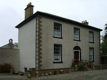 Ballycogly HouseFarm house · 41 yd
Explorer Tom Ballycogly House nearly got famous when a castle nearby claimed all the credit, but this place knows better. Nicholas Barrington built it with a doorcase that’s actually quite good quality, unlike its neighbour's reputation. Keep your distance and appreciate that early nineteenth-century charm.
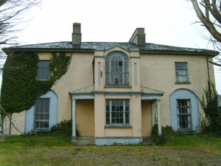 Thorn VilleFarm house · 546 yd
Explorer Tom Thorn Ville will rate your outfit on a scale of one to ten before you even knock. John Lloyd built it to impress, not to intimidate, so keep your chin up. It’s just a fancy farm house with delusions of grandeur.
St. Catherines WellHoly well · 661 ydExplorer Tom St. Catherines Well in Petitstown is just eight metres from a road where cars honk at it for being slow. It’s a concrete box with a whitethorn tree over it that looks like it’s guarding a secret. Stand back, squint, and it looks like a castle if you ignore the overflow pipe.
Enclosure in BallycoglyEnclosure · 979 ydExplorer Tom Enclosure in Ballycogly would get 'Best Effort Circle' on its tombstone, which is honestly more than most people can say about their own lives. It’s tucked inside another fort like a secret you’re not supposed to tell anyone. Hang around long enough and you'll hear a story from a local.
1798 Memorial PlaqueMemorial · 2.0 miExplorer Tom The whole parish once argued about this 1798 Memorial Plaque until they all agreed to just leave it alone and pretend nothing happened. It’s still got that 'we’ll see' look on its face, so pop by and tell it it's looking well to settle the score. Pop by and tell it it's looking well.
 Irish Agricultural MuseumMuseum · 3.5 mi
Explorer Tom Irish Agricultural Museum has a tall tale about a hidden tunnel leading straight to the local pub, but every farmer I ask swears they haven’t seen it since 1974 or so. It’s packed with old tractors that look like they’re judging your farming techniques from behind dusty glass windows, which is both comforting and terrifying. It's free, it's odd, what more do you want?
 Japanese cedar3.6 mi
Explorer Tom Japanese cedar gave up sugar for Lent but somehow got fatter and more majestic anyway. It’s just standing there judging everyone who thinks they understand what a proper tree is. Stick around for the light changing, it's a show.
 Dawn Redwood3.6 mi
Explorer Tom Dawn Redwood’s first owner probably had an escape plan involving a very fast horse and zero regrets. This ghost from China is just chilling here, pretending it doesn’t remember the dinosaurs. Look up, the best bit is always higher than you think.
_-_geograph.org.uk_-_3715787.jpg/250px-Castles_of_Leinster,_Ballyhealy,_Wexford_(1)_-_geograph.org.uk_-_3715787.jpg "Photo: Mike Searle, Wikimedia Commons · CC BY-SA 2.0") Castle (in ruins)Castle, tower house · 4.0 mi
Castle (in ruins)Castle, tower house · 4.0 miExplorer Tom Castle in Ballyhealy Castle claims it’s older than the Cheevers family, but really it’s just been standing there since the 13th century pretending it’s not tired. William Chevre signed a charter nearby, so maybe he built it while waiting for the ink to dry. Toast it with a cup of tea and move on to the next one.
 Kilmore Quay - Crehen Twinning MemorialMemorial · 6.6 mi
Explorer Tom Kilmore Quay - Crehen Twinning Memorial has a least favourite visitor who always tries to take pictures of the anchor without reading the sign, which drives the local gulls absolutely mental with frustration. It’s got that 'we survived a sinking ship' energy, making it feel like the whole place is holding its breath in solidarity. Perfect spot to practise
 Kilmore Quay Walking TrailVisitor information · 6.8 mi
Explorer Tom Kilmore Quay Walking Trail is secretly proud of a potato. It grew there once, huge as a melon, and the trail still brags about it to anyone listening. Go on, count the windows and get it wrong like I did.
More historic places in County Wexford · All of County Wexford

What do you know about this place?Tap to add a comment or ask a question