
Places near here
Photo credits
- National Inventory of Architectural Heritage
- Richard Webb, Geograph · Creative Commons Attribution-ShareAlike 2.0
- Wanfried-Dublin, Wikimedia Commons · CC BY-SA 4.0
- Kenneth Allen, Geograph · CC BY-SA 2.0
- Mike Searle, Wikimedia Commons · CC BY-SA 2.0
- David Perez, Wikimedia Commons · CC BY 3.0
- Willow, Wikimedia Commons · CC BY 2.5
- Oliver Dixon, Geograph · CC BY-SA 2.0
- D Gore, Geograph · CC BY-SA 2.0
- GTD Aquitaine, Wikimedia Commons · Public domain
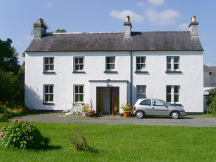 Arnasbrack HouseHouse · 320 yd
Explorer Tom Arnasbrack House is being claimed by a local who says he invented the concept of 'winding driveway' back in his day. It’s a pleasingly proportioned rural dwelling sitting quietly at the end of its own little kingdom. Take a picture of that grand entrance for me!
 Graveyard781 yd
Explorer Tom Graveyard in Kilross is hiding behind a church ruin, looking like it’s trying to blend into the background of history. Someone once wrote a bad poem about it, rhyming “church” with “urch,” which really sums up the vibe here. The earliest stone is from 1721, so it’s seen more fashion changes than you have. Look up, the best bit is always higher than you think.
 Druids AltarCourt tomb · 832 yd
Explorer Tom Druids Altar in Carrownagh would survive a zombie attack by just lying down and pretending to be part of the landscape. It’s basically a stone skeleton that gave up on life centuries ago. If it rains, blame me.
 Giants GraveArchaeological place · 933 yd
Explorer Tom Giants Grave in County Sligo started because two lads bet fifty quid that they could find a bigger stone than the one next door. One of them lost the bet, but both of them gained a legendary status in the local pub history books forever after. A proper spot for a flask of tea and a big think.
 Castle DarganHouse · 1331 yd
Explorer Tom Castle Dargan in Sligo is suspicious of the postman because he keeps delivering bills instead of invitations to parties. The Victorian porch is fancy enough to make you feel small, but it's just being dramatic. Give that central barge a wave from the road and don't let it see you shiver.
 Drumcondra Castle (in Ruins)Castle, tower house · 1.1 mi
Explorer Tom Drumcondra Castle is currently being courted by a cow who thinks it’s a luxury loft. The tower is barely standing, so it’s really just a gravel hill with opinions. Get a photo with it before it gets a better agent.
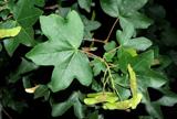 Field Maple2.3 mi
Explorer Tom Field Maple in County Sligo is cursed so that if you don't wave when passing, your left shoe falls off. It’s not magic, just bad luck with excellent timing. It's the kind of place that makes a dull Tuesday interesting.
 European ash2.5 mi
Explorer Tom European ash in County Sligo was nearly sold as a horse because a farmer mistook its shape for a mane. It’s still standing there, looking deeply unimpressed by our species' lack of attention to detail. Take a breath of that air, it's older than your car.
 Slishwood Island EastIslet · 3.0 mi
Explorer Tom Slishwood Island East is where a priest once lost a bet and has been sulking about it ever since, probably hiding in the trees. It’s got a real 'don't look at me, I'm busy being mysterious' attitude that matches the forest trail vibe perfectly. Stand on the spot and imagine the gossip it's heard.
 Green IslandIslet · 3.0 mi
Explorer Tom Green Island would bring its own lawn chairs and a very aggressive bottle of wine to any party, expecting everyone else to arrive with snacks. It’s basically a garden that thinks it’s a nightclub. Make up your own legend and I'll swear it's true.
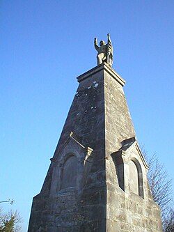 Battle of CollooneyBattle · 3.1 mi
Explorer Tom The Battle of Collooney in County Sligo took about four cups of tea to build up the energy needed for the fighting, and they used them all up. Bartholomew Teeling put up a monument there, which is basically a giant finger wagged at history for forgetting this little scuffle. Stop the car, it's worth the hazard lights.
 Battlefield in Carricknagat (leyny By.),rinn (leyny By.),bleachgreen,collooney,ardcottenBattlefield · 3.1 mi
Explorer Tom Battlefield in Carricknagat survived a massive storm by just staying put, which is impressive for a spot with such a chaotic history of conflict and confusion. It’s got a real 'I’ve seen it all' attitude that makes you feel like your problems are tiny in comparison to the old wars. Go at sunset and thank me later.
More archaeology and monuments in County Sligo · All of County Sligo

What do you know about this place?Tap to add a comment or ask a question