What is recorded here
From the National Monuments Service (Archaeological Survey of Ireland) record LE018-018
Places near here
Picture notes
- Computer-made picture. It does not show this monument.
- Computer-made picture. It does not show this mountain top.
- National Inventory of Architectural Heritage
- Computer-made picture. It does not show this playground.
- Computer-made picture. It does not show this walking route.
- Kenneth Allen, Wikimedia Commons · CC BY-SA 2.0
- Computer-made picture. It does not show this cliff.
 Fairy fort / earthen ringfort in Annagh UpperFairy fort / earthen ringfort · 189 ydComputer-made picture
Explorer Tom Fairy fort / earthen ringfort in Annagh Upper has caught my eye in Annagh Upper, County Leitrim. I bet a fairy fort / earthen ringfort with a name like that could keep me talking all afternoon; I'm already inventing a daft little scene for it, and I'll stop before it turns into history.
 Sweathouse in Cornageeha (drumahaire By.)Sweathouse · 608 ydComputer-made picture
Explorer Tom Sweathouse in Cornageeha has caught my eye in Cornageeha, County Leitrim. I bet a sweathouse with a name like that could keep me talking all afternoon; I'm already inventing a daft little scene for it, and I'll stop before it turns into history.
 Kilduff LowerMountain / peak · 837 ydComputer-made picture
Explorer Tom Kilduff Lower sits in County Cavan, a mountain recorded for its location and any linked names or public map references.
 DowraMountain / peak · 892 ydComputer-made picture
Explorer Tom Dowra is a gentle peak in County Cavan, probably the kind you’d enjoy walking to with a thermos of tea.
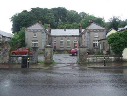 Dowra Court HouseCourt house, garda station/constabulary barracks · 1105 yd
Explorer Tom Dowra Court House was built right after Independence to deal with border drama, which is basically my daily life. It used to be a Garda station too, so the walls are thick with secrets. The prophecy says a penguin will judge you here.
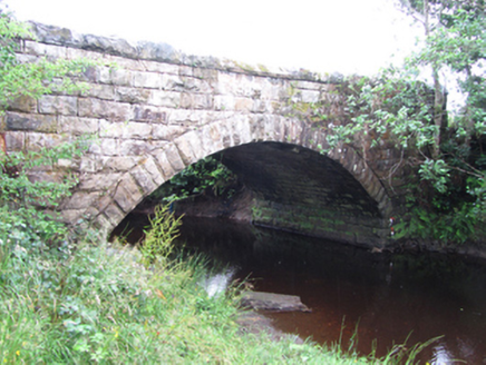 New BridgeBridge · 1181 yd
Explorer Tom New Bridge in Kilduff Lower spans two counties and thinks it’s the boss of both. I bet Queen Victoria visited secretly to check if her bridge was still standing, but nobody admits it. Keep your eyes open for royal ghosts.
 Children's playground1224 ydComputer-made picture
Explorer Tom Maybe this Children's playground in County Cavan is where the local rabbits come to practice their jumps.
 Cavan WayWalking route · 1552 ydComputer-made picture
Explorer Tom Cavan Way has caught my eye in County Leitrim. I bet a walking route with a name like that could keep me talking all afternoon; I'm already inventing a daft little scene for it, and I'll stop before it turns into history.
 Miners Way & Historical TrailWalking route · 1687 ydComputer-made picture
Explorer Tom The Miners Way & Historical Trail invites you to follow old footsteps through the scenic County Cavan countryside.
 TobermurrySpring · 2.2 mi
Explorer Tom As a holy well, Tobermurry might just wish you luck if you bow politely, so let's go see if the water is actually magical.
 The PlaygroundCliff · 3.1 miComputer-made picture
Explorer Tom The Playground cliff sounds like a toddler’s tantrum turned into geology! It’s just a big rocky edge in Cavan waiting for someone to slide down it. Don’t trip over your own feet while admiring the view, yeah?
 CarrignahastaCliff · 3.4 miComputer-made picture
Explorer Tom Carrignahasta has caught my eye in County Leitrim. I bet a cliff with a name like that could keep me talking all afternoon; I'm already inventing a daft little scene for it, and I'll stop before it turns into history.
More archaeology and monuments in County Leitrim · All of County Leitrim

What do you know about this place?Tap to add a comment or ask a question