What is recorded here
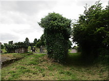
On top of a E-W ridge, overlooking Lee valley to N. 1842, 1904 and 1938 OS 6-inch maps show curving field fence NNW->SSE and bend in laneway SSE->W, suggesting presence of roughly circular enclosure (c. 200m N-S), within which is Aglish graveyard (CO072-092003-). Field in SW quadrant named 'Friar's Field' on all three OS 6-inch maps, but no record of friary ever existing here (Gwynn and Hadcock 1988). Field fences about graveyard are now levelled but outline of enclosure still visible as cropmark from air (see photograph, Mould 1981, 108). Included by Hurley (1982, 305) in list of 'early sites'.
On top of a E-W ridge, overlooking Lee valley to N. 1842, 1904 and 1938 OS 6-inch maps show curving field fence NNW->SSE and bend in laneway SSE->W, suggesting presence of roughly circular enclosure (c. 200m N-S), within which is Aglish graveyard (CO072-092003-). Field in SW quadrant named 'Friar's Field' on all three OS 6-inch maps, but no record of friary ever existing here (Gwynn and Hadcock 1988). Field…
From the National Monuments Service (Archaeological Survey of Ireland) record CO072-092001
The monument record does not grant public access. Check the route and ask the landowner before entering private land.
- What survives
- Recorded monument
Places near here
Photo credits
- Jonathan Thacker, Geograph · Creative Commons Attribution-ShareAlike 2.0
- National Inventory of Architectural Heritage
- David P Howard, Geograph · CC BY-SA 2.0
- Richard Fensome, Wikimedia Commons · CC BY-SA 2.0
- Jonathan Thacker, Geograph · CC BY-SA 2.0
- Jo and Steve Turner, Geograph · CC BY-SA 2.0
- Sole Origami, Wikimedia Commons · CC BY-SA 4.0
- Frederick Dean, Geograph · CC BY-SA 2.0
- Hywel Williams, Wikimedia Commons · CC BY-SA 2.0
- Frabjousone, Wikimedia Commons · CC BY-SA 4.0
 Grave YardGraveyard · 28 yd
 Aglish HouseCountry house · 388 yd
 Farran WoodWood · 1254 yd
 monument1516 ydCoachford Greenway (End)Visitor information · 1.2 mi
 Kilcrea CastleWood · 2.3 mi
 Kilcrea Castle (in Ruins)Castle, tower house · 2.3 mi
 Carrigadrohid Castle (in Ruins)Castle, tower house · 4.0 mi
 Carrigadrohid CastleHeritage attraction · 4.0 mi
 Mullinhassig WaterfallWaterfall · 4.4 mi
.jpg/250px-St._Olan's_Well_-_geograph.org.uk_-_2832674_(cropped).jpg "Photo: Hywel Williams, Wikimedia Commons · CC BY-SA 2.0") St Olans WellHoly well · 5.3 mi
St Olans WellHoly well · 5.3 mi Michael Collins MemorialMemorial · 6.3 mi
More archaeology and monuments in County Cork · All of County Cork
What do you know about this place?