
Places near here
Photo credits
- National Inventory of Architectural Heritage
- Algirdas at Lithuanian Wikipedia, Wikimedia Commons · Public domain
- Irishrover1980, Wikimedia Commons · CC BY-SA 4.0
- Gatepainter, Wikimedia Commons · CC BY-SA 4.0
- Kieran Campbell, Geograph · CC BY-SA 2.0
- AndreasDelp, Wikimedia Commons · CC BY-SA 4.0
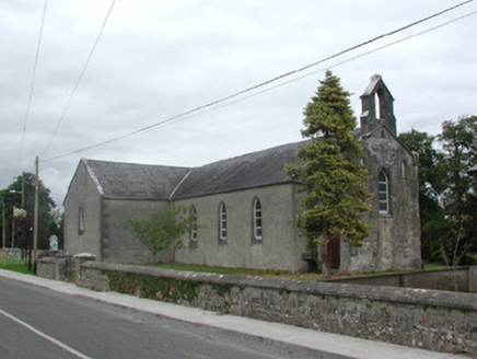 Kilteevan Community CentreChurch/chapel · 320 yd
Explorer Tom Kilteevan Community Centre is a church that would order a full chipper with extra mushy peas if it could get to the takeaway window. It’s got those pinnacles and hood mouldings because plain was never going to cut it in this neighborhood, honestly. Just admire the stone surrounds from outside and maybe leave a small donation!
St Bridgets WellHoly well · 709 ydExplorer Tom St Bridgets Well in Cloonmurly would have 'Rescued Dog' chiselled on its tombstone if it were a statue made of granite and stubbornness. It moved locations in disgust when a landlord tried to heal an injured dog at the wrong well, which is peak drama for a water source. Snap one photo, then put the phone away and actually look.
AltarMass-rock · 1175 ydExplorer Tom Altar in Cloontogher thinks tourists from Dublin are just noisy goats in suits who don't appreciate the fine art of two limestone boulders sitting side by side. It’s inside a rath with a modern cross next door, so it’s like living with a loud neighbour who won’t stop quoting scripture. Go back in winter, it's a different animal.
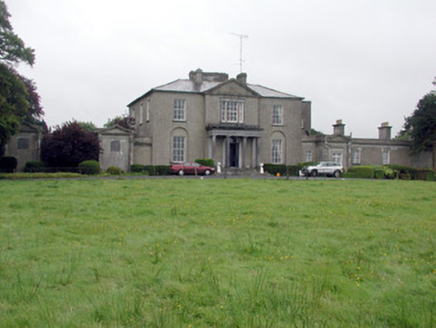 Carrowroe ParkCountry house · 2.2 mi
Explorer Tom Carrowroe Park in County Roscommon has a Doric portico and a crenellated bellcote that really shouldn’t be on a country house. It’s got flanking wings that stretch out like it’s showing off its arms. The architecture is fancy but slightly confused, so if the gate's locked, wave from afar like you own the place.
Big IslandForest · 2.3 miExplorer Tom Big Island in County Roscommon is technically a forest, but it acts like a very smug island. It would describe the 1800s to a teenager as a time when everyone wore pants. Have a wander and a wonder.
 Pedunculate Oak2.7 mi
Explorer Tom Pedunculate Oak in County Roscommon has a local legend that a giant used to nap in its branches and once sneezed so hard it blew away his hat. The tree looks suspiciously like it’s trying to hide from the memory, which makes sense given the trauma of having a giant roommate. If it rains, blame me.
 Roscommon CastleCastle · 3.1 mi
Explorer Tom Roscommon Castle in County Roscommon would explain the 1800s to a teenager by saying, 'Imagine your mum's house, but with more damp and fewer Wi-Fi signals.' It’s been sitting there judging everyone since before we had proper trousers, still looking mighty smug about it. Go now, before it gets famous.
FerrinchIslet · 3.1 miExplorer Tom Ferrinch would definitely bring a bottle of wine and a very opinionated story about its own history if it was invited to a party with the other islands. It’s always the first one there and the last one to leave, don't get me wrong at all. Get there early and have it all to yourself.
Cruit BayBay · 4.1 miExplorer Tom Cruit Bay is playing hard to get, likely because the local sheep have unionised and are demanding better grazing rights. They say the water tastes like regret and old boots, which is frankly rude for a body of water with such a delicate name. Leave nothing but footprints and a bad pun.
 Galey CastleCastle, tower house · 4.7 mi
Explorer Tom Galey Castle nearly got famous in 1351 when it accidentally hosted a poetry reading for the whole county. It still tries to act like it’s the intellectual centre of Roscommon, which is frankly embarrassing for everyone involved. Hum something sad nearby, it adds atmosphere.
 Rathcline CastleBawn · 4.9 mi
Explorer Tom Rathcline Castle: This bawn is the ultimate shortcut that leads nowhere fast, like a dead-end in your head. Just one wall thick? That’s structural integrity with a sense of humour. Sit on a wall near it and pretend you're in a painting.
 InchcleraunIsland · 5.7 mi
Explorer Tom Inchcleraun has two names, a monastery and enough legend to keep me talking well beyond the boat ride. It lies in Lough Ree between Roscommon and Longford, covering about fifty-eight hectares. Saint Diarmaid's community was founded around 560, leaving ruins now protected as a national monument. The Irish name points to Clothru, a queen in story, and Maeve also gets a chapter in the island's folklore. I would settle their argument over who owned the best view, but it is wiser to separate tales from surviving stone. There is no road across the lake; arrange a permitted boat, confirm landing and return, and respect the old religious ground. Look back at both shores once you arrive. The island sits between counties and between several very different kinds of history.
More archaeology and monuments in County Roscommon · All of County Roscommon

What do you know about this place?Tap to add a comment or ask a question