What is recorded here
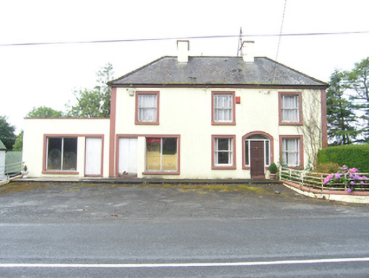
Detached three-bay two-storey over basement house, built c.1930, with entrance between eastern bays and integral shop to western bay, set on sloping site exposing full basement level to rear with recent return. Flat roofed single-storey over basement side extension to the west, c.1970. Hipped slate roof with clay ridge tiles, eaves course, and cast-iron rainwater goods. Substantial smooth rendered chimneystacks with capstones indicating a tripartite internal plan and hearth-lobby entrance to domestic section. Smooth rendered walls, stucco pilasters to corners. One-over-one pane timber sliding sash windows with wide margin panes, stone sills, and raised stucco surrounds. Segmental-headed entrance with stucco surround, replacement door with shallow fanlight, and sidelights over low sills. Shopfront having raised stucco architrave enclosing door and large fixed double pane window divided vertically over a low sill. Double-leaf timber battened door to shop. Historic shop interior with back screen to display window with diagonal sheeting. Timber battened doors to basement level to rear. External concrete stair up to ground level of return. Range of outbuildings to side with rendered walls and pitched corrugated-iron roofs. House and shop open directly to footpath, set back from road, with small garden at east bay enclosed by horizontal railing on plinth wall.
A substantial house and former shop having a number of formal elements including the segmental-arch entrance with fanlight and sidelights, and raised stucco detailing, reflecting the prosperity of local businesses of this nature in the early part of twentieth century. Countryside shops were an important part of the social fabric in rural areas, and the integrated shop retains features of its historic interior. Though no longer in commercial use, the building remains an eyecatching roadside feature, retaining much of its historic fabric and character.
From the Buildings of Ireland (National Inventory of Architectural Heritage) record 40402712
This does not grant access. Most recorded buildings are privately owned; view them only from public ground unless the owner allows entry.
Places near here
CarrickacromanMountain / peak · 1555 yd farm house1.1 miBeehiveHouse, stables · 1.1 miCarrickacromanMountain / peak · 1.7 miRaven's RockNamed rock · 3.4 miCormeen Glebe ForestForest · 3.6 miGiant's GraveArchaeological place · 4.6 miCavan County MuseumMuseum · 5.9 miSheela-na-gig (present location) in Kilmore (castlerahan By., Ballyjamesduff Ed)Sheela-na-gig (present location) · 5.9 miCabragh RingfortArchaeological place · 7.7 miLoughanleaghForest · 9.6 miBush IslandIslet · 10 mi
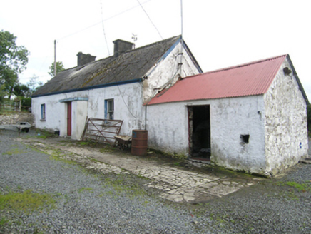 farm house1.1 mi
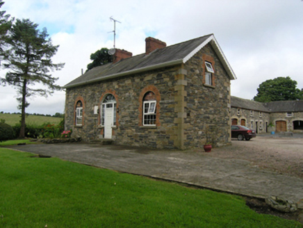 BeehiveHouse, stables · 1.1 miCarrickacromanMountain / peak · 1.7 miRaven's RockNamed rock · 3.4 mi
 Cormeen Glebe ForestForest · 3.6 miGiant's GraveArchaeological place · 4.6 mi
.jpg/250px-Ballyjamesduff-Cavan_County_Museum_(geograph_7350383).jpg "Photo: Ian Rob, Wikimedia Commons · CC BY-SA 2.0") Cavan County MuseumMuseum · 5.9 mi
Cavan County MuseumMuseum · 5.9 mi Sheela-na-gig (present location) in Kilmore (castlerahan By., Ballyjamesduff Ed)Sheela-na-gig (present location) · 5.9 mi
 Cabragh RingfortArchaeological place · 7.7 mi
 LoughanleaghForest · 9.6 mi
 Bush IslandIslet · 10 mi
Pictures: National Inventory of Architectural Heritage; Eric Jones, Geograph · CC BY-SA 2.0; Ian Rob, Wikimedia Commons · CC BY-SA 2.0; Deadstar, Wikimedia Commons · CC BY-SA 4.0; Pamela Norrington, Wikimedia Commons · CC BY-SA 2.0; Oliver Dixon, Geograph · CC BY-SA 2.0
More historic places in County Cavan · All of County Cavan
What do you know about this place?