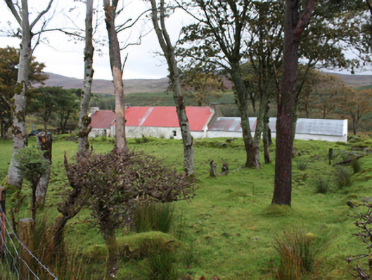
What is recorded here
Detached single-storey vernacular house, built c. 1860, with bed outshot to rear and single-bay single-storey extension to north-east gable. Pitched corrugated-metal roof, with rendered gable coping and rendered gable ended chimneystacks with rendered coping to house and to north-east gable of extension. Roughcast…
Read the whole record
From the Buildings of Ireland (National Inventory of Architectural Heritage) record 40901816
Places near here
Photo credits
- Patrice78500, Wikimedia Commons · Public domain
- Andreas F. Borchert, Wikimedia Commons · CC BY-SA 4.0
- Carroll Pierce, Wikimedia Commons · CC BY-SA 2.0
- Andreas F. Borchert, Wikimedia Commons · CC BY-SA 3.0 de
- National Inventory of Architectural Heritage
- DAYVEHUSE, Wikimedia Commons · CC BY-SA 4.0
- Michael Dibb, Geograph · CC BY-SA 2.0
- Wanfried-Dublin, Wikimedia Commons · CC BY-SA 4.0
- N Chadwick, Geograph · CC BY-SA 2.0
- N Chadwick, Wikimedia Commons · CC BY-SA 2.0
- David Ayrton, Geograph · CC BY-SA 2.0
 Urris HillsMountain / peak · 1049 yd
Explorer Tom Urris Hills in County Donegal sounds like it's having a proper chat with the Gap of Mamore, judging by that caption. It’s a mountain that seems to know exactly where its boundaries are, even if the trail doesn't.
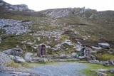 Saint Éigneach's WellHoly well · 1.1 mi
Explorer Tom Saint Éigneach's Well sits right on top of Mamore Gap, where pilgrims used to go barefoot around seven cairns. That’s a serious blister-fest, but apparently worth it for the spiritual glow-up at this mountain summit. There’s even a Lourdes grotto and Padre Pio statue nearby, so it’s got a very eclectic holy vibe.
 Mamore GapViewpoint · 1.1 mi
Explorer Tom Mamore Gap provides a scenic pause point, offering lovely views over the surrounding hills and valleys in County Donegal.
 Mamore HillMountain / peak · 1.5 mi
Explorer Tom Right then, we've got ourselves a proper mountain called Mamore Hill tucked away in County Donegal. I imagine it's the sort of peak that looks like it’s been napping through the centuries, waiting for someone curious enough to poke its nose and see what’s over the ridge.
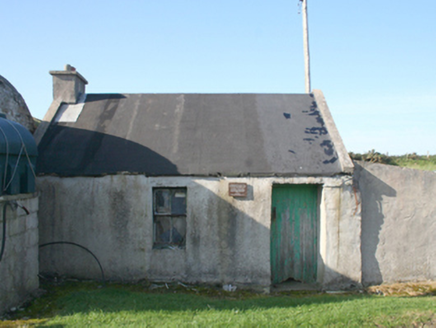 forge/smithy1.5 mi
Explorer Tom Forge or smithy in Lenan was built around 1840. Its plaque remembers the crew of Wellington Bomber W5653, who died in the Urris crash on 11 April 1941; their bodies were laid in this forge before transfer to Dunree and burial in Britain. I let the plaque speak here.
 Gortleck Catholic ChurchChurch/chapel · 1.7 mi
Explorer Tom Gortleck Catholic Church has a cross-shaped stone with cupmarks that look like someone used a spoon to dig tiny holes. I picture the stone wondering if those were actually fingerprints from a very sticky giant’s hand. Did it get itchy?
 Gap of Mamore ViewpointViewpoint · 1.7 mi
Explorer Tom Gap of Mamore Viewpoint sits along the Wild Atlantic Way, offering a dramatic look at this famous gap in County Donegal.
.jpg/250px-Ballyannan_(3).jpg "Photo: Wanfried-Dublin, Wikimedia Commons · CC BY-SA 4.0") Ballyannan Portal TombPortal tomb · 2.3 mi
Ballyannan Portal TombPortal tomb · 2.3 miExplorer Tom Ballyannan Portal Tomb is perched on Aghaweel Hill, offering a sprawling view across Lough Swilly to the Fanad mountains. It’s been standing in this exact roofless condition since at least 1846, so it’s got plenty of time to collect stories. The two tall portal stones are like ancient doorkeepers who never quite locked up.
 Dunree CentreMuseum · 2.4 mi
Explorer Tom Dunree Centre is one building in the Fort Dunree grounds, where the fort's story takes six exhibition chapters to tell. I would give them proper time: a place that has watched over Lough Swilly for so long deserves more than a quick look at the view.
 Dunree HeadHeadland · 2.4 mi
Explorer Tom Dunree Head juts out proudly into the Donegal waters, a classic headland that definitely deserves your admiring gaze.
 Glenevin WaterfallWaterfall · 3.9 mi
Explorer Tom Glenevin Waterfall offers a stunning view of the falls in County Donegal, a natural spectacle waiting to be discovered.
 Glenevin Waterfall, ClonmanyWaterfall · 3.9 mi
Explorer Tom Glenevin Waterfall sits at the head of a maintained walk near Clonmany, one of the few falls with a proper path.
More historic places in County Donegal · All of County Donegal

What do you know about this place?Tap to add a comment or ask a question