DDiscover AloneMapAbout

House in Leat More

House
House in Leat More
Photo: National Inventory of Architectural Heritage · Report the wrong picture

What is recorded here

Detached three-bay two-storey vernacular house, built c. 1850, having single-bay single-storey lean-to extension to the east gable end. Now out of use and derelict. Pitched purple slate roof with rendered copings to gable ends, projecting stone eaves course, and with central rendered chimneystack having rendered…

Read the whole record
Detached three-bay two-storey vernacular house, built c. 1850, having single-bay single-storey lean-to extension to the east gable end. Now out of use and derelict. Pitched purple slate roof with rendered copings to gable ends, projecting stone eaves course, and with central rendered chimneystack having rendered coping over. Remains of lime render over rubble stone walls. Square-headed window openings with rendered sills, and with remains of two-over-two pane timber sliding sash windows to front elevation at first floor level and to the rear elevation; square-headed window openings to main elevation at ground floor level having paired four-over-two pane timber sliding sash windows. Square-headed doorway offset to one side of the centre of the main elevation; door now missing. Located in the rural countryside to the east of Carrickart, and to the south-west end of the Fanad Peninsula overlooking Mulroy Bay. House set to south of road along a private lane with modern agricultural buildings to south-east of site.
Although now sadly no longer occupied, this interesting vernacular house retains its original form and architectural character. Its visual expression and integrity is enhanced by the retention of salient fabric such as the natural slate roof and the timber sliding sash windows, albeit in increasingly poor condition. The irregular fenestration pattern and small openings are characteristic of many vernacular buildings; however, the diminishing scale of the window openings towards the eaves, the paired window openings to the front elevation at ground floor level, and the central chimneystack provide some limited formal architectural language to the composition. It is robustly built using local rubble and field stone, which helps create an appealing composition of some rustic appeal. Sensitively restored, this building at Leat More makes a positive contribution to the architectural and built heritage to the south-west end of the Fanad Peninsula, and is a modest addition to the landscape in its current condition.

From the Buildings of Ireland (National Inventory of Architectural Heritage) record 40901724

This does not grant access. Most recorded buildings are privately owned; view them only from public ground unless the owner allows entry.

What do you know about this place?Tap to add a comment or ask a question

What you write will be public.

Places near here

Photo credits
  • National Inventory of Architectural Heritage
  • Andreas F. Borchert, Wikimedia Commons · CC BY-SA 4.0
  • Kenneth Allen, Geograph · CC BY-SA 2.0
  • Golfing in Ireland; photographer not stated, Source publisher
  • CLG na nDúnaibh (official club site publisher); individual photographer not named, nadunaibh.ie
  • John M, Geograph · CC BY-SA 2.0
  • Patrice78500, Wikimedia Commons · CC BY-SA 3.0
  • Rossographer, Geograph · CC BY-SA 2.0
  • Kieran Evans, Wikimedia Commons · CC BY-SA 4.0
John MorrowHouse · 333 yd

Explorer Tom John Morrow in Leat Beg has a shop sign that spells his name with two r’s! Built around 1930, I bet the sign painter…
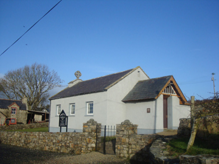
Leat Beg Church (Clondavaddog)Church/chapel · 567 yd

Explorer Tom Leat Beg Church (Clondavaddog) has square-headed windows that look like they got stuck in a filing cabinet. Built…

Mevagh High CrossCross, High cross · 1.6 mi

Explorer Tom Mevagh High Cross is a stark, undecorated slab standing in the graveyard of a ruined medieval church. It’s simple and…

Carrigart HotelHotel · 1.7 mi

Explorer Tom Carrigart Hotel on Main Street is where ghosts go to relax after haunting castles all day long. Ask for room four; if…

Caife Na SraideCafé · 1.7 mi

Explorer Tom Caife Na Sraide in County Donegal is on the street, so expect to share your pastry with pigeons. It's charming, it's…

Rosapenna Hotel & Golf ResortGolf course · 2.3 miPáirc na nDúnaibh, DowningsGAA ground · 2.3 miMoross CastleCastle, tower house · 2.3 mi

Explorer Tom Moross Castle was built in 1532 and sits on a tiny rocky island connected by a causeway. By 1622, someone had slapped a…

Rosses StrandBeach / strand · 2.6 mi

Explorer Tom Rosses Strand sits on the Rosguill peninsula with the sort of Donegal scenery that makes a short stop expand into an…

Cnoc na SleáMountain / peak · 2.6 mi

Explorer Tom Cnoc na Sleá means 'hill of the spear', though I would leave any spear firmly in the name. The guide also calls this…

DowningsOfficial bathing water · 2.7 mi

Explorer Tom Downings Beach gives its village a front row seat at Sheephaven Bay, with pale sand, calm-looking water and Muckish…

The Murder HoleCave · 2.9 mi

Explorer Tom The Murder Hole would cope perfectly on a reality show by hiding in the corner and pretending the camera crew wasn’t…

More historic places in County Donegal · All of County Donegal

Add to this placeAdd a picture Add a detailed tip Add a story

Explore the map1,095,414 places to discover

Next place · or swipeJohn Morrow