What is recorded here
From the National Monuments Service (Archaeological Survey of Ireland) record GA052-006
Places near here
Photo credits
- Maker not stated on source page, www.pinterest.com
- Maker not stated on source page, en.wikipedia.org
- Maker not stated on source page, www.locationscout.net
- Michael Earnshaw, Wikimedia Commons · CC BY-SA 2.0
- Michael Earnshaw, Geograph · CC BY-SA 2.0
- National Inventory of Architectural Heritage
- Marathon, Geograph · CC BY-SA 2.0
- Digital Eye, Wikimedia Commons · CC BY-SA 4.0
- Maker not stated on source page, ulster.gaa.ie
- Maker not stated on source page, www.dreamstime.com
- Nmwood189, Wikimedia Commons · CC BY-SA 4.0
 Standing stoneStanding stone, pair · 208 yd
Explorer Tom This pair of standing stones is fighting over who gets to be the head of the household, and frankly, neither is…
 Standing stone in ÚraidStanding stone · 799 yd
Explorer Tom Standing stone in Úraid says it’s ‘just a rock’ but I can tell you’re lying, mate. It’s been standing guard over…
 Stone row in BoheeshalStone row · 1.7 mi
Explorer Tom Boheeshal is hiding a stone row that the Vikings probably missed because they were too busy getting lost in the mists.…
 Binn MhórMountain / peak · 2.8 mi
Explorer Tom Binn Mhór means 'great peak', and its 661 metre shoulder rises above Mám Éan in Connemara's Maumturks. The hill has the…
 Binn Mhor West TopMountain / peak · 2.9 mi
Explorer Tom Binn Mhor West Top has a tall tale about a hidden tunnel to the local pub that locals swear exists but nobody can find.…
 bridge3.3 mi
Explorer Tom Bridge in Ardderrynagleragh has a ghost that's too lazy to haunt it properly, so it just stands there looking tired. It…
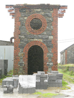 Maam Cross Railway StationRailway station · 3.5 mi
Explorer Tom Maam Cross Railway Station in Lurgan has a secret it would tell after a few pints: the cattle platform was for cows who…
 Screebe WaterfallWaterfall · 3.5 mi
Explorer Tom Screebe Waterfall would totally ace a reality show by screaming louder than anyone else and refusing to share the…
 Teach an PhiarsaighHeritage attraction · 4.0 mi
Explorer Tom Teach an Phiarsaigh in County Galway is doing its best to look mysterious, which is hard when you've got no actual…
 Cumann Peile na bPiarsaigh GAA pitchGAA ground · 4.0 mi
 Mapped cemeteryCemetery · 4.7 mi
Explorer Tom This mapped cemetery’s opinion of the local sheep is that they are terrible dancers and even worse gardeners. They keep…
 CastlekirkCastle · 5.6 mi
Explorer Tom Castlekirk is called Hen's Castle, and no, I did not name it after my poultry empire. The ruin stands on a tiny…
More historic places in County Galway · All of County Galway

What do you know about this place?Tap to add a comment or ask a question