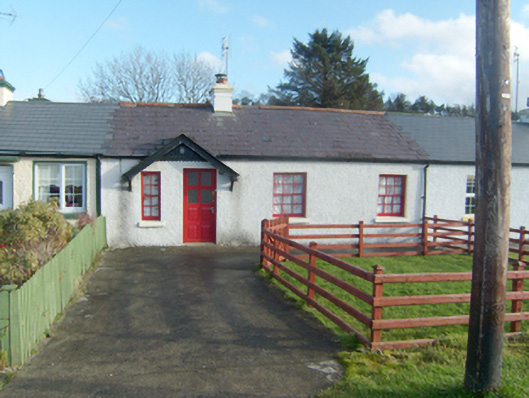
What is recorded here
Attached terraced four-bay single-storey former local authority house, built c. 1910, having canopy porch over main doorway. One of a terrace of six buildings. Now in use as a private dwelling with single-storey extension to the rear (east). Pitched natural purple slate roof with terracotta ridge tiles, replacement…
Read the whole record
From the Buildings of Ireland (National Inventory of Architectural Heritage) record 40837020
Places near here
Photo credits
- National Inventory of Architectural Heritage
- Eric Jones, Geograph · Creative Commons Attribution-ShareAlike 2.0
- Kenneth Allen, Geograph · CC BY-SA 2.0
- louise price, Wikimedia Commons · CC BY-SA 2.0
- Kenneth Allen, Wikimedia Commons · CC BY-SA 2.0
- Ronnie Nijboer, Wikimedia Commons · CC0
- louise price, Geograph · CC BY-SA 2.0
 Myrtle CottageHouse · 679 yd
Explorer Tom Myrtle Cottage is actually named on a map from 1905! Most houses just blend into the background, but this one got its own little label. I bet the postman knew exactly which door to knock on without asking.
 St. Conall’s Catholic ChurchChurch/chapel · 722 yd
Explorer Tom St. Conall’s Catholic Church was built in 1974 and is the sixth of seven churches designed by Liam McCormick in Donegal. The dramatic angular design marks a radical change from his earlier curvilinear forms, creating an austere and bold composition. The light and space within the building are carefully orchestrated to create a reflective atmosphere.
 GlentiesHostel · 800 yd
Explorer Tom Glenties Hostel is where you sleep in a bed that has seen far too much drama already. Bring an earplug because snoring here is guaranteed to wake the dead. Snap one photo, then put the phone away and actually look.
 St. Connell's Museum and Heritage CentreMuseum · 817 yd
Explorer Tom St. Connell's Museum and Heritage Centre lets me go from an old courtroom to the cells below, then into stories of the workhouse and Donegal railways. That is a lot of Glenties history packed into one building. I would leave the cells to the displays and keep my own visit on the friendly side of the door.
 Kennedy's Bar and RestaurantRestaurant · 856 yd
Explorer Tom Kennedy's Bar and Restaurant is definitely hiding a secret menu involving only cabbage and regret. I bet the barman knows more about ghosts than he does about cocktails, so keep your ears peeled for whispers while you eat.
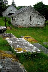 Inishkeel Graveyard near GlentiesGraveyard · 935 yd
Explorer Tom Inishkeel Graveyard near Glenties was rectangular in the older survey, but its south side sat on part of a roughly circular rise. Some of that rise lay beyond the west wall, about fifty metres across. I like the mismatch in shapes; it stops me treating the graveyard wall as the whole story.
 Burial GroundGraveyard · 1.8 mi
Explorer Tom Burial Ground in Kilrean Upper is stacked with layers of history that refuse to stay quiet. You’ve got 12th-century sandstone window heads and a cross-slab with swastika patterns sitting right next to modern graves. It’s a bit of a chaotic archaeological buffet, so keep your eyes peeled for the odd carvings.
 Letterilly Standing StonePublicly named standing stone · 3.1 mi
Explorer Tom Letterilly Standing Stone is standing there all by itself, probably wondering why it didn't get invited to the more exciting stone circles nearby. It’s a lovely bit of quiet company if you need a moment to think about how old the ground really is. Just make sure you ask permission before you start having a chat with it.
 Wych Elm3.7 mi
Explorer Tom Another Wych Elm in County Donegal is having an identity crisis because all the others look the same. It's very sensitive about its bark texture. Permission slips are mandatory here. Give it a little pat on the head.
 Binn BhánMountain / peak · 4.2 mi
Explorer Tom Binn Bhán is recorded as a mountain / peak in County Donegal. It is hilarious that the ground goes from boggy to suddenly hard right at the top, like nature hit the brakes. I bet my boots would be utterly confused.
 CarnaweenMountain / peak · 4.3 mi
Explorer Tom Carnaween has Diarmuid Ó Duibhne hiding in its name, at least in the old local telling. There was even a first-Sunday-in-June climb in the record. I would ask the hero whether he liked hills this much, but I would check current access before trying to follow him.
 Disert GraveyardGraveyard · 5.2 mi
Explorer Tom Disert Graveyard is a D-shaped pocket inside two larger enclosures, with at least 34 low uninscribed grave markers noted across its centre. The account also records a striking custom: people took soil from near the altar because it was reputed to drive rats from houses. I'd keep that as a belief people held, not a promise from the place.
More historic places in County Donegal · All of County Donegal

What do you know about this place?Tap to add a comment or ask a question