What is recorded here
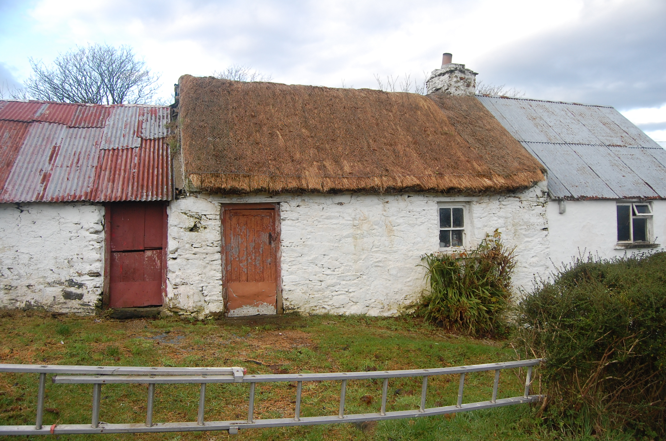
Two-bay single-storey vernacular house, built c.1780, with single-storey additions to each end, single-bay to north being addition to house or conversion of former outbuilding and two-bay outbuilding to south. Pitched thatched roof to older part of house, tied down with horizontal wire fixed to metal pegs at eaves. Limewashed rubble stone walls and chimneystack. Square-headed two-over-two pane timber sliding sash windows, one to front and two to rear, with ogee horns, having masonry sill to front opening and timber to rear. Attic steps and fireplace intact to interior. Attached bay to north has pitched corrugated-iron roof, limewashed cement-rendered walls and replacement casement window and has lean-to shed to north end with corrugated-metal roof. Outbuilding to south has pitched corrugated-iron roof, limewashed rubble stone walls and square-headed timber battened doors. Single-bay single-storey rubble outbuilding on opposite side of road, with pitched slate roof and timber battened half-door. Elevated hillside site with extensive views of surrounding countryside.
This diminutive house, with its two adjoining outbuildings, is visible on both the first edition and 1903-07 OS maps, though as part of a settlement of some thirty buildings of different sizes, only a small number of whose constituent buildings survived by 1903-07. The house had been the middle of three similar detached buildings in a row aligned north-south. Its neighbours have been demolished. Such settlements developed between about 1700 and 1850, and this one was certainly in existence at the time of the first edition of the Ordnance Survey (1837-42). Although the northern adjoining outbuilding has been largely rebuilt, its original base appears to survive, and the southern outbuilding survives. The house retains its (probably flax) thatched roof, and timber battened door and sash windows, and is remarkably intact and a rare and significant survival of a once common building type.
This does not grant access. Most recorded buildings are privately owned; view them only from public ground unless the owner allows entry.
Places near here
 TempodeshaChurch · 768 yd
 Not indicated, TempodeshaHoly well · 809 yd
 Gortnavern EnclosureEnclosure · 813 yd
 The Curlewhouse · 1494 yd
 Rough IslandIslet · 1.3 mi
 Cranberry IslandIslet · 1.6 mi
 WoodquarterForest recreation place · 1.9 mi
 Croaghan HillMountain / peak · 3.1 mi
 Wych ElmWych Elm · 4.4 mi
 Ballymastocker StrandViewpoint · 4.6 mi
 Wild Atlantic Way:Ballymastocker StrandVisitor information · 4.6 mi
 PortsalonOfficial bathing water · 4.8 mi
Other information
Photo: National Inventory of Architectural Heritage · Website use allowed for educational or private purposes with source credit