
Places near here
Photo credits
- Rossographer, Wikimedia Commons · CC BY-SA 2.0
- Bart Whelan, Wikimedia Commons · CC BY-SA 2.0
- N Chadwick, Wikimedia Commons · CC BY-SA 2.0
- Rossographer, Geograph · CC BY-SA 2.0
- No machine-readable author provided. Bogman assumed (based on copyright claims)., Wikimedia Commons · CC BY-SA 2.5
- Kenneth Allen, Geograph · CC BY-SA 2.0
- Robert Bone, Wikimedia Commons · CC BY-SA 2.0
- Joseph Mischyshyn, Geograph · CC BY-SA 2.0
- National Inventory of Architectural Heritage
- Robert Bone, Geograph · CC BY-SA 2.0
 Maghera StrandBeach / strand · 1562 yd
Explorer Tom Maghera Strand put mountains behind the sand and caves in the cliffs, as if one dramatic backdrop would not do. The local beach guide places it beside Slievetooey and warns about high tides and currents. I would admire the cave mouths from a safe spot and let current local advice decide whether a closer look is sensible.
 O'Boyle's Fort at StonebrookNamed fort remains · 1.0 mi
Explorer Tom O'Boyle's Fort at Stonebrook is basically just curving stones pretending to be a mighty stronghold. It’s near Ardara and sounds like it belonged to some serious local legends, though the walls might not hold up against much more than a strong breeze.
 Maghera CavesSea caves · 1.1 mi
Explorer Tom Maghera Caves have enough openings to make me lose count: thirteen beside Maghera Strand, including Uaimh a' nDaoine, the Cave of the People. That name gives my imagination a full day's work. These are real sea caves, though, so I would keep my distance from the entrances.
 Assaranca WaterfallWaterfall · 1.5 mi
Explorer Tom Assaranca Waterfall sits right next to the road between Ardara and Maghera, so lazy is a word you could use if it had a mouth. Saint Patrick probably looked at it after a heavy rain and said, 'Even I can't get past this splash.' Ten minutes here and you'll have a yarn for the pub.
 Maghera WaterfallWaterfall · 1.5 mi
Explorer Tom Maghera Waterfall is hiding a treasure chest at its base that Tom swears contains nothing but a rusty biscuit tin and a very sad sock. It splashes over itself dramatically to make sure nobody notices the tiny, sad object it's desperately trying to protect from the world. Dive in if you're brave enough.
 IllancreeveIslet · 1.6 mi
Explorer Tom Illancreeve in County Donegal is being judged by the rabbits, who think it’s too pointy and not fluffy enough for their liking. It’s probably just a rock that got stuck in a weird position and can't move out of its own way anymore. Take a breath of that air, it's older than your car.
 Carrickalahagh HeadlandPublicly named cliff or headland · 1.7 mi
Explorer Tom Carrickalahagh Headland is a cliff that would teach history by throwing pebbles at you every time you get a fact wrong, which is basically constantly for most people. It’s got the attitude of a teacher who has seen too many students trip over their own feet on this very path. A handy spot to stretch your legs and your imagination.
 Tramore StrandBeach / strand · 1.9 mi
Explorer Tom Rosbeg’s Tramore Strand has a whole sand department working behind it. A geological field guide describes dunes along this open coast and more by the Loughros Mór estuary, as if one set of dunes could not decide where to settle. This is the southern Tramore, not its namesake near Dunfanaghy.
 outbuilding2.4 mi
Explorer Tom Outbuilding in Shanaghan was built around 1860 with a rounded straw-thatch roof tied to stone pegs in its rubble walls. The inventory calls thatched outbuildings a rare survival. I thought such careful roofing would belong to the house; this work building has kept the fancy curve for itself.
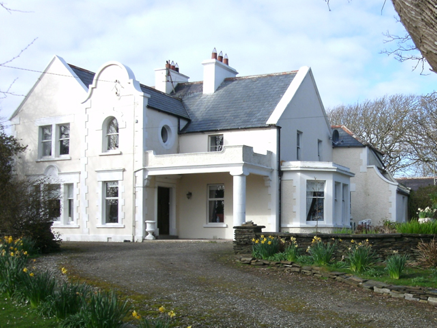 Kiltoorish HallHouse · 2.8 mi
Explorer Tom Kiltoorish Hall keeps a close eye on O'Boyle's Island from its hilltop perch. I wonder if Mr. O'Boyle ever tried to swim across in his bathrobe, or if he just enjoyed shouting at the water? Built around 1880, it looks like it’s waiting for a very specific visitor.
 Sliabh TuaidhMountain / peak · 2.9 mi
Explorer Tom Sliabh Tuaidh was saved by a hero so obscure he hasn’t even got a name, just a really bad haircut and a grudge. He fixed the whole mess in one night and left without taking credit or a single photo of himself. Linger, it's not going anywhere and neither should you.
 Killasteever FortEnclosure · 3.4 mi
Explorer Tom Killasteever Fort would tell you its secret after three pints: that it’s actually two forts pretending to be one for insurance purposes. It’s bisected by a boundary wall, which is the most bureaucratic way to split an ancient stronghold in half since the invention of the fence. Perfect spot to practise your best tour-guide voice.
More historic places in County Donegal · All of County Donegal

What do you know about this place?Tap to add a comment or ask a question