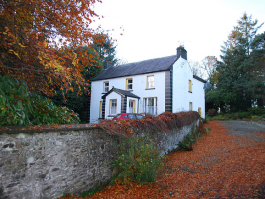
What is recorded here
Detached three-bay two-storey house, built c. 1880, having single-storey projecting entrance porch to the centre of the front elevation (south-east), added c. 1920, and with modern two-storey flat roof extension to the rear (north-west). Pitched natural slate roof having blue clay ridge tiles, and with rendered verges…
Read the whole record
From the Buildings of Ireland (National Inventory of Architectural Heritage) record 40907111
Places near here
Picture notes
- National Inventory of Architectural Heritage
- Computer-made picture. It does not show this monument.
- Computer-made picture. It does not show this walking route.
- Kenneth Allen, Geograph · CC BY-SA 2.0
- Kenneth Allen, Wikimedia Commons · CC BY-SA 2.0
- Computer-made picture. It does not show this mountain top.
- 60McCurdy, Wikimedia Commons · CC BY-SA 3.0
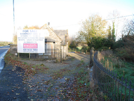 demesne walls/gates/railings277 yd
Explorer Tom Demesne walls in Gortgranagh used to have two carved stone lions standing guard around 1863! They got moved all the way to Rash House in County Tyrone, which feels like a very cheeky long-distance move for two statues. I wonder if they missed their old post?
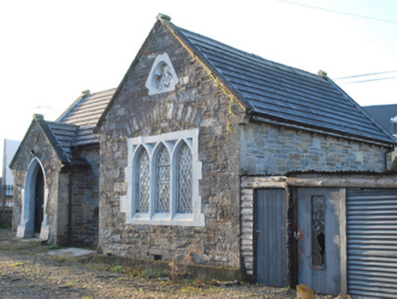 Clonleigh HouseGate lodge · 288 yd
Explorer Tom Clonleigh House gate lodge in Gortgranagh is an orphaned beauty from the mid-nineteenth century, left behind when its main house got demolished. It’s got cast-iron quarry glazing and cut stone detailing that make it look like a very sad but expensive doorman’s booth.
 Architectural fragment in Edenmore (clonleigh North Ed)Architectural fragment · 1068 ydComputer-made picture
Explorer Tom Architectural fragment in Edenmore refers to three medieval carved mouldings found partly buried by Clonleigh's ruined church. The monument account separately describes parts of the church's north and south walls and wicker marks on an arch. A separate Maltese-cross slab was found nearby. Small finds, church walls and a cross slab: three pieces of this place's story.
 Cross-slab in Edenmore (clonleigh North Ed)Cross-slab · 1068 ydComputer-made picture
Explorer Tom This Cross-slab in Edenmore is officially gone, likely buried deep within the 6th-century Clonleigh graveyard. We know it once had a deeply carved Maltese cross with a raised boss at the centre, but now you’re just left staring at marshy ground near the River Deele. It’s a bit of a ghost story, isn’t it?
 GreenbraeWalking route · 1.1 miComputer-made picture
Explorer Tom Greenbrae has caught my eye in County Tyrone. I bet a walking route with a name like that could keep me talking all afternoon; I'm already inventing a daft little scene for it, and I'll stop before it turns into history.
 McCauley's RestaurantRestaurant · 1.6 mi
Explorer Tom McCauley's Restaurant serves fish and chips that are likely swimming in batter. If the fish looks suspiciously like a rock, don't worry, it's probably just very well-seasoned stone from the Atlantic Ocean.
 Battle site: battle of the fords, Central crossing, 1689 in Magirr; Town Parks of StrabaneBattle site: battle of the fords, Central crossing, 1689 · 1.7 mi
Explorer Tom Battle site: battle Of the fords, Central crossing, 1689 in Magirr, Town Parks Of Strabane has caught my eye in Magirr; Town Parks OF Strabane, County Tyrone. I bet a battle site: battle of the fords, central crossing, 1689 with a name like that could keep me talking all afternoon; I'm already inventing a daft little scene for it, and I'll stop before it turns into history.
 Battle of Knockavoe BattlefieldBattlefield · 1.8 mi
Explorer Tom Battle of Knockavoe Battlefield has caught my eye in County Tyrone. I bet a battlefield with a name like that could keep me talking all afternoon; I'm already inventing a daft little scene for it, and I'll stop before it turns into history.
 Abercorn FactoryHeritage attraction · 1.9 mi
Explorer Tom Abercorn Factory has caught my eye in County Tyrone. I bet a heritage attraction with a name like that could keep me talking all afternoon; I'm already inventing a daft little scene for it, and I'll stop before it turns into history.
 Binnion HillMountain / peak · 2.9 miComputer-made picture
Explorer Tom Binnion Hill saw a battle in 1557, which is way cooler than your Monday morning commute. The O'Donnells won, so maybe they’re still guarding the top? A good place to forget your phone for ten minutes.
 Argery HillMountain / peak · 3.1 miComputer-made picture
Explorer Tom Argery Hill is damp and dreary, probably thinking it's sophisticated while we're just freezing our arses off in the rain. It's got that 'I prefer the weather' vibe that makes you want to hug it for comfort. Go on a wet day, because honestly, it really does suit the moody atmosphere.
 Mongavlin CastleHouse, fortified house · 3.5 mi
Explorer Tom Mongavlin Castle is quite the sturdy survivor, with large walls and corner turrets still standing proudly from its days as a fortified house. Legend has it to be the home of Ineen dubh, mother of Red Hugh O'Donnell, so you’re stepping into some serious local lore here.
More historic places in County Donegal · All of County Donegal

What do you know about this place?Tap to add a comment or ask a question