Places near here
Photo credits
- Eric Jones, Geograph · Creative Commons Attribution-ShareAlike 2.0
- National Inventory of Architectural Heritage
- Sue Mischyshyn, Wikimedia Commons · CC BY-SA 2.0
- Joseph Mischyshyn, Geograph · CC BY-SA 2.0
- N Chadwick, Geograph · CC BY-SA 2.0
- Kenneth Allen, Wikimedia Commons · CC BY-SA 2.0
- P L Chadwick, Geograph · CC BY-SA 2.0
- Rossographer, Geograph · CC BY-SA 2.0
- Kieran Evans, Geograph · CC BY-SA 2.0
- Joseph Mischyshyn, Wikimedia Commons · CC BY-SA 2.0
- louise price, Wikimedia Commons · CC BY-SA 2.0
 Saint Mary's Catholic ChurchChurch/chapel · 456 yd
Explorer Tom Saint Mary's Catholic Church in Belcruit would order a massive chipper with extra gravy if it ever hit the pub. It’s dressed up in Gothic stone like it owns the place, but it’s really just trying to look impressive from across the sound. Tell me it doesn’t sing hymns when the wind blows!
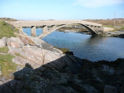 foot bridge918 yd
Explorer Tom Foot bridge in Ardun tapers and rises toward the middle like it’s trying to bow. Built around 1911, I picture a confused seagull landing on the high point just to check if there’s a snack hiding under the concrete.
 An ChruitIsland · 1.6 mi
Explorer Tom Cruit Island has a bridge, so you can arrive without a sailor's tale, but it will send you home with a song. This inhabited Donegal island in the Rosses gave us Seán McBride, who wrote The Homes of Donegal in 1955. The Irish-language song Thíos Cois na Trá Domh also comes from here and still travels through the Gaeltacht. I would offer to sing both as we cross, but the bridge is short and your patience shorter. The island's musical history belongs to real people and a living community, not a stage set for my performance. Follow public roads and permitted shore access, give homes room and check any tide or weather plans before going down to the water. Stop after the bridge and look back. A small crossing can carry a great deal of Donegal with it.
 Bonner's BarPub · 2.1 mi
Explorer Tom Bonner's Bar is very colourful because Bonner probably painted it after drinking too much last Friday. The first owner’s escape plan involved sliding under the counter and never coming back. Look serious, nod slowly, you're basically an expert now.
 CarrickfinnOfficial bathing water · 2.6 mi
Explorer Tom Carrickfinn brought a beach and then sneaked a meadow in behind it. Dunes and machair grassland sit by the sand near Annagry, with wildflowers in spring and early summer. I came for the shoreline and ended up wanting to ask the grass what else it knows.
 Stone Circle near Donegal AirportPublicly named stone circle · 2.7 mi
Explorer Tom Stone Circle near Donegal Airport is sitting on the flattest patch of earth I’ve ever seen. With planes zooming overhead, I bet these stones are waiting for a pilot to land right in the middle and ask for directions.
 The Lobster PotRestaurant · 2.8 mi
Explorer Tom The Lobster Pot in Burtonport is known as Kelly’s, so don't be surprised if they call you by the wrong name. There might even be a hidden tunnel to the pub. Tell the next person you meet it's haunted. It might be.
 Annagary HillMountain / peak · 3.0 mi
Explorer Tom Annagary Hill. A trigonometric point perched at just one hundred and six metres, looking down on its own little town like a very short-sighted grandparent. I reckon the view is mostly rooftops and a bit of sky.
 Braade StrandBeach / strand · 3.1 mi
Explorer Tom “Braade Strand” in County Donegal would bring a massive bucket of sand and a grumpy crab to any party, which honestly sounds like a perfect combo for most gatherings. It’s a stretch of shore where the wind is loud enough to drown out your inner critic and make you feel small and free. Practise your Irish on it, it won't correct you.
 UaighIsland · 3.4 mi
Explorer Tom Uaigh means cave, but Owey Island's bigger surprise is how much life its small Donegal outline once held. Around 120 hectares lie off Kincasslagh, rising to 102 metres at Moylemore. More than a hundred people once made a living through fishing and seaweed-fed growing. Full-time settlement ended in the mid-1970s, while families still return to old cottages in summer. There is no mains electricity or public water supply, so I will not offer to put the kettle on without asking whose house I am in. Old school and post-office remains recall a busier year-round place. Any visit needs a suitable arranged boat and return, calm conditions and respect for private cottages and fields. Walk carefully toward the rocky north, if permitted. The empty-looking ground has more voices than my first impression would allow.
 Cliffs of OweyPublicly named cliff or headland · 3.8 mi
Explorer Tom Cliffs of Owey thinks the road leading to it is a personal insult to its majestic stature. It would prefer you arrive by helicopter or perhaps teleport, but the bumpy track just makes it feel like an afterthought in its own life. Toast it with a cup of tea and move on to the next.
 Cairn, LoughanurePublicly named cairn · 4.4 mi
Explorer Tom Cairn, Loughanure is a place where the name suggests a connection to water and perhaps a specific local story. I imagine it’s one of those spots that has been part of the landscape for a long time, maybe used by people who lived nearby. It’s a name that makes you think about how places get their names.
More historic places in County Donegal · All of County Donegal

What do you know about this place?Tap to add a comment or ask a question