DDiscover AloneMapAbout

House in Ballysaggart

House
House in Ballysaggart
Photo: National Inventory of Architectural Heritage · Report the wrong picture

This does not grant access. Most recorded buildings are privately owned; view them only from public ground unless the owner allows entry.

What do you know about this place?Tap to add a comment or ask a question

What you write will be public.

What is recorded here

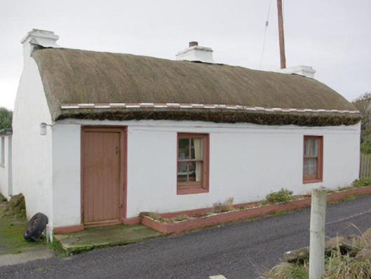
Detached three-bay single-storey vernacular house, built c. 1820, having single-bay single-storey thatched extension to the rear (south-west) at the north-west corner and with modern single-storey flat-roofed extension to the rear at the south-east end. Pitched/domed straw thatched roof having three rendered…

Read the whole record
Detached three-bay single-storey vernacular house, built c. 1820, having single-bay single-storey thatched extension to the rear (south-west) at the north-west corner and with modern single-storey flat-roofed extension to the rear at the south-east end. Pitched/domed straw thatched roof having three rendered chimneystacks, one to either gable end (south-east and north-west) and one to the centre; pitched/domed straw thatched roof to rear extension to the rear at the north-west end having rendered chimneystack to the north-west gable end. Ropes and wire mesh over thatched roofs tied to rail below eaves level. Flat felt roof to modern extension. Smooth rendered walls over projecting smooth rendered plinth. Square-headed window openings having smooth rendered reveals, and with two-over-two pane timber sash windows; timber casement windows to rear elevation. Square-headed doorway to the south-east end of main elevation (north-east) having smooth rendered reveals and battened timber door. Stone threshold to doorway. Road-fronted along small rural road adjacent to Ballysaggart Pier, overlooking Inver Bay to the east and north-east. Yard adjacent to the south-east. Located to the south of Dunkineely on the east side of St. John’s Point.
This vernacular house retains much of its early character and form despite various alterations over the years, and is an appealing feature in the scenic landscape along St. John’s Point and adjacent to Ballysaggart Pier. Modest in scale, it exhibits the simple and functional form of vernacular building in Ireland. The retention of the early timber sliding sash windows adds substantially to its integrity and visual appeal. Of particular interest in the survival of the thatched roof, which is now sadly becoming increasingly rare in Donegal. The rounded roof is a typical feature of thatched houses located close to the sea in exposed areas in the north-west of Ireland, while the rails to the eaves were used to tie ropes (and sometimes nets or wire mesh) over the roof to secure it against the prevailing winds as is the case here at Ballysaggart. This building is notable for the unusual thatched return to the rear, which creates a distinctive double-pile appearance that is unusual to find with vernacular buildings of this type, which are usually extended along its length. This arrangement may indicate that this building was originally terraced or semi-detached, which would eliminate the possibility of extension along its length (Ordnance Survey first edition six-inch map of 1837 depicts two terraces of buildings, one to either side of the road, here at this time. The arrangement of the openings to the front elevation, and the occurrence of three chimneystacks, are also unusual, and indicate that this building has been altered on a number of occasions. The location of this building adjacent to Ballysaggart Pier suggests that it was originally built as a fisherman’s house. This house represents an interesting surviving example of a once ubiquitous building type in the rural Irish countryside, and is a valuable addition to the extensive vernacular heritage of County Donegal.

From the Buildings of Ireland (National Inventory of Architectural Heritage) record 40909819

Places near here

Photo credits
  • Andreas F. Borchert, Wikimedia Commons · CC BY-SA 4.0
  • Maker not stated on source page, visionsofthepastblog.com
  • Maker not stated on source page, tr.pinterest.com
  • National Inventory of Architectural Heritage
  • Maker not stated on source page, in.pinterest.com
  • Maker not stated on source page, www.tripadvisor.ie
  • Maker not stated on source page, kate-grigoryeva.livejournal.com
  • Jonathan Wilkins, Geograph · CC BY-SA 2.0
  • louise price, Geograph · CC BY-SA 2.0
  • louise price, Wikimedia Commons · CC BY-SA 2.0
  • David Dixon, Wikimedia Commons · CC BY-SA 2.0
Ballysaggart FriaryReligious house, Franciscan Third Order Regular · 66 yd

Explorer Tom Ballysaggart Friary’s church ruins stand on the east side of St John’s Point. The survey dates a cattle crush inside…

Ballysaggart Old Burial GroundBurial ground · 158 yd

Explorer Tom Ballysaggart Old Burial Ground is a modest rectangular patch tucked right next to the friary on the coast edge. It’s…

Ballyederlan Fairy FortFairy fort / earthen ringfort · 1233 yd

Explorer Tom Ballyederlan Fairy Fort sits on a slight ridge where the east side has been largely chewed up. The interior is flat…
outbuilding1675 yd

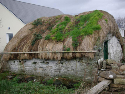
Explorer Tom Outbuilding in Ballyederlan holds its thatch down with ropes and wire tied to timber pegs. I picture the wind pulling…

Rahan Far Fairy FortFairy fort / earthen ringfort · 1.6 mi

Explorer Tom Rahan Far Fairy Fort has an internal diameter of 31.4m by 35m, which is quite a generous space for a fairy gathering.…
watch tower, pill box1.7 mi

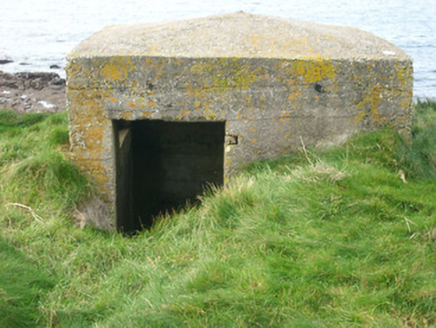
Explorer Tom Watch tower, Pill box in Rahan Near looks like a concrete egg that forgot to harden. Built around 1940, its flimsy…

Castle Murray Coastal Promontory FortPromontory fort, coastal · 1.7 mi

Explorer Tom Castle Murray Coastal Promontory Fort sits on a coastline where the sea is always trying to reclaim its territory. It’s…

McSwynes Castle in ruinsCastle, tower house · 1.7 mi

Explorer Tom Welcome to McSwynes Castle in ruins, where Niall Mar McSwyne drew his final breath back in 1524. It’s a bit of a ghost…

Rabley HillMountain / peak · 2.1 mi

Explorer Tom Rabley Hill might look like just another bump in County Donegal, but it’s got a secret history written in stone. I’d…

Carntullagh HeadHeadland · 2.2 mi

Explorer Tom Carntullagh Head is a small south-facing Donegal point near Killybegs, where sheep-grazed grass and lichen-covered rock…

Rotten IslandIslet · 2.4 mi

Explorer Tom Rotten Island sounds like a pirate's insult, but its lighthouse story is serious. The light guides boats into Killybegs…

Rashenny PointHeadland · 2.6 mi

Explorer Tom Rashenny Point in County Donegal was once the prime spot for smuggling contraband teacups and very suspiciously large…

More historic places in County Donegal · All of County Donegal

Add to this placeAdd a picture Add a detailed tip Add a story

Explore the map1,095,414 places to discover

Next place · or swipeBallysaggart Friary