Places near here
Photo credits
- National Inventory of Architectural Heritage
- Kenneth Allen, Wikimedia Commons · CC BY-SA 2.0
- Kenneth Allen, Geograph · CC BY-SA 2.0
- Richard Webb, Wikimedia Commons · CC BY-SA 2.0
- Rossographer, Geograph · CC BY-SA 2.0
- Ronnie Nijboer, Wikimedia Commons · CC0
- MPF, Wikimedia Commons · CC BY-SA 3.0
- Michael Murtagh, Geograph · CC BY-SA 2.0
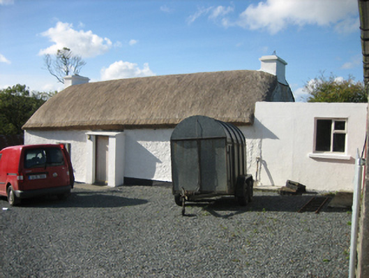
 Ardroe CottageHouse · 671 yd
Explorer Tom Ardroe Cottage has little metal pegs sticking out of its thatched eaves! Built around 1780, they look like giant safety pins holding the whole roof together. I wonder if anyone ever swung from them to reach the chimney pot?
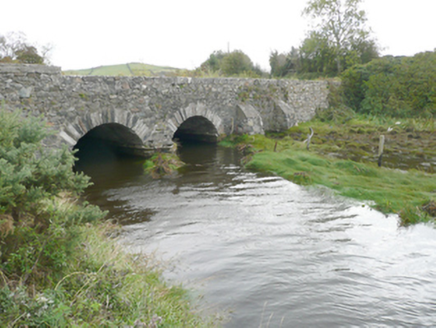 New BridgeBridge · 1522 yd
Explorer Tom New Bridge has a V-shaped stone nose pointing at the sea! Built around 1860, I wonder if the tide ever tried to bite that pointy bit? It looks like it’s daring the waves to come closer.
 Drumfad Lower Standing StoneStanding stone · 1.1 mi
Explorer Tom This standing stone in Drumfad Lower used to stand proudly on a ridge with sweeping views of Trusk More, though it did take a tumble during a storm back in 1998. After a rescue excavation to uncover its original socket pit, it was carefully re-erected so it could keep watch over the plateau.
 PortsalonOfficial bathing water · 2.0 mi
Explorer Tom Portsalon runs in a wide sandy curve along Lough Swilly, with Knockalla rising behind it. I can almost see a giant pencil trying to draw that line in one stroke. That's the bit that grabs me: sand, water and mountains making one huge sweep, without needing a beauty contest to tell me so.
 Moross CastleCastle, tower house · 2.3 mi
Explorer Tom Moross Castle was built in 1532 and sits on a tiny rocky island connected by a causeway. By 1622, someone had slapped a thatched roof on the ruins while it lay waste, which is peak medieval DIY. Only the southwest corner survives now, but that narrow causeway makes it feel like you’re walking onto a very defensive boat.
 Ballymastocker StrandViewpoint · 2.6 mi
Explorer Tom Ballymastocker Strand Viewpoint would bring a very aggressive bag of crisps and a blanket with no pattern to any party, just to make sure everyone feels slightly uncomfortable. It’s the kind of place where you stand around wondering if you should be doing something more productive, like swimming, but the wind says otherwise. Grand place for a sulk or a snog, your call.
 Wild Atlantic Way:Ballymastocker StrandVisitor information · 2.6 mi
Explorer Tom Wild Atlantic Way:Ballymastocker Strand in County Donegal would post on social media that it’s 'too majestic for your average selfie stick,' which is exactly the kind of arrogance we’ve come to expect from it. The sand there holds grudges against anyone who digs too deep, and the sign above it looks permanently unimpressed by your efforts. Bring a map, get lost anyway, that's the fun.
 Wych Elm2.8 mi
Explorer Tom Wych Elm in Donegal is the site of a fierce fairy dispute over parking rights, as they argue about who gets the best branch view under its sprawling canopy. It’s a sturdy tree that has seen more seasons than you have teeth, standing firm while the small folk throw their tantrums below. Bring sandwiches, the gulls will thank you.
 Hazel2.9 mi
Explorer Tom Hazel in County Donegal has a long list of former names because every farmer who passed by thought they could do a better job naming it. It’s got that identity crisis energy where it just shrugs and lets them call it whatever they want. Bring a camera and your most suspicious face.
 Knockalla FortMartello tower and coastal battery · 3.4 mi
Explorer Tom Knockalla Fort guarded the Donegal coast and Lough Swilly during the Napoleonic Wars. Its building record describes a rounded two-storey tower, a dry moat, firing holes and gun mounts on the roof. That is a lot of defence in one place. The record names five other forts nearby; I wonder how their views joined up.
 The Village InnPub · 3.6 mi
Explorer Tom The Village Inn sounds like it contains an actual village, but it’s just a pub on Main Street. Ask the bartender if he knows the local king; he probably doesn’t. Stick around for the light changing, it's a show.
 McGinley'sPub · 3.6 mi
Explorer Tom McGinley's on Main Street has a guy who swears he saw a leprechaun pay his tab. He never left, probably still polishing glasses that aren't there in the back room. Wave at the cows, they're the real locals.
More historic places in County Donegal · All of County Donegal

What do you know about this place?Tap to add a comment or ask a question